


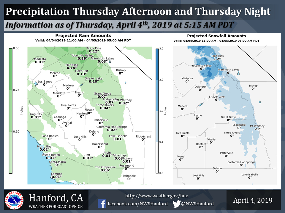
Projected rainfall totals for Mariposa: 0.14"
Projected rainfall totals for Oakhurst: 0.13"
Projected rainfall totals for Yosemite Valley: 0.26"
April 4, 2019 - The National Weather Service Hanford Office reports a weak storm system will impact Central California this afternoon and tonight.
In the San Joaquin Valley, measurable rainfall should be confined to areas from Fresno County northward.
Snow levels will be around 7,000 feet.
Portions of Yosemite National Park above 7,000 feet could pick up one to three inches of new snow.
 Area Forecast Discussion
  National Weather Service San Joaquin Valley - Hanford CA
  444 AM PDT Thu Apr 4 2019

  .SYNOPSIS...A weak disturbance will bring a chance of light
  precipitation mainly to the mountains today then a stronger
  system will bring a chance for more significant precipitation
  Friday into Saturday. Warmer and drier conditions are expected
  for the start of next week, ahead of another weak system.

  &&

  .DISCUSSION...Some high clouds are pushing across the south half
  of our area ahead of incoming jet energy, while temperatures
  across the district remain relatively mild. The approaching
  Northeast Pacific trough is progged to bring precipitation to
  central California by later this morning. Blended model guidance
  confines the precip mainly to our mountain and foothill zones
  through tonight, with snow levels running around 7000 ft and no
  more than a few inches of accumulation expected.

  By Friday morning additional shortwave energy brings another round
  of precip to our area. Although this system is forecast to bring
  more significant moisture, model QPF continues to trend downward.
  The bulk of the precip is progged to fall Friday afternoon and
  evening with snow levels around 6 to 7 thousand ft. Levels will
  fall as low as 5000 ft by early Saturday morning as the precip
  tapers off. Accumulations are expected to be as much as 3-6 inches
  at the higher elevations with this system. Rainfall amounts will
  range from near 1/10 of an inch in the south Valley to around 1/4
  inch around Merced. Up to 1/2 inch of rain can be expected in the
  higher terrain below the snow line.

  The passing systems will bring some gusty winds to the desert
  zones this afternoon and especially Friday afternoon/evening when
  local gusts over 40 mph can be expected.

  A rebuilding ridge over the weekend will bring drier and warming
  conditions into early next week, with temperatures reaching as
  much as 5-12 degrees above climo by Monday. Another approaching
  low pressure system will lower temperatures and bring a chance for
  mainly mountain showers by Tuesday, followed by more shortwave
  ridging Wednesday.
Source: NWS

