


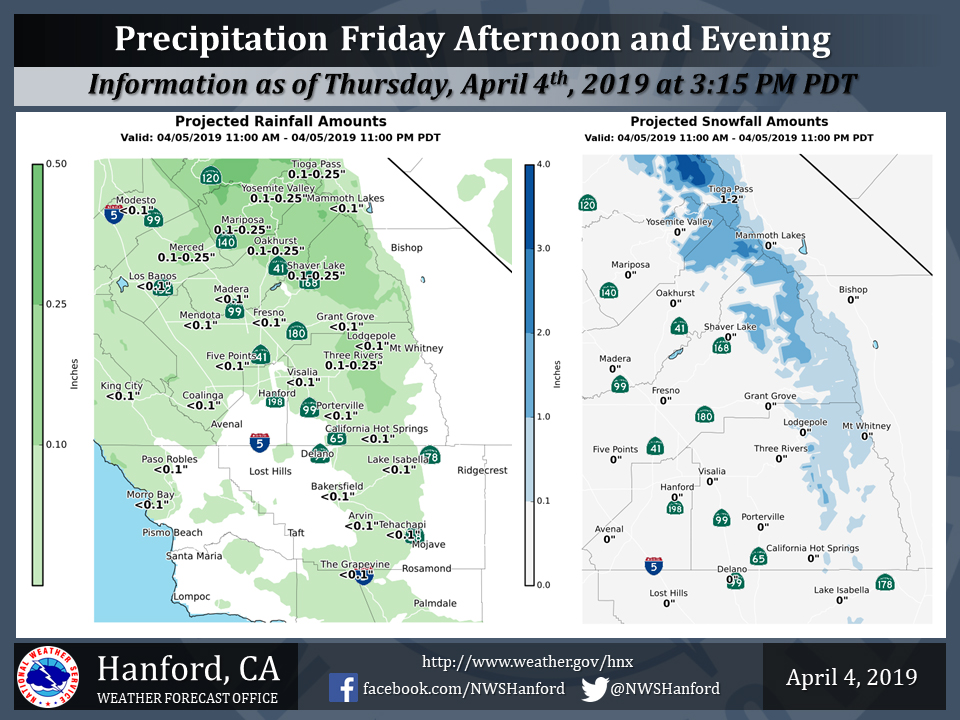
Projected rainfall totals for Mariposa: 0.10" to 0.25"
Projected rainfall totals for Oakhurst: 0.10" to 0.25"
Projected rainfall totals for Yosemite Valley: 0.10" to 0.25"
April 5, 2019 - The National Weather Service Hanford Office reports a weak storm system will impact Central California today.
In the San Joaquin Valley, measurable rainfall should be fairly light and mainly confined to areas from Fresno County northward.
Snow levels will be around 7,000 feet. Portions of Yosemite National Park above 7,000 feet could pick up one to three inches of new snow.
Area Forecast Discussion
  National Weather Service San Joaquin Valley - Hanford CA
  218 AM PDT Fri Apr 5 2019

  .SYNOPSIS...A weak weather system will move across the
  area today and this evening. The storm track will shift
  northward this weekend as high pressure builds to the south
  of the region. &&

  .DISCUSSION...Satellite imagery shows one vorticity center moving
  southeast towards the Mexican border and the next larger weather
  system moving quickly towards the California coast from 130W. This
  feature is progged to arrive this afternoon and move quickly east
  during the late afternoon and evening. Overnight, ridging is
  progged by models to quickly build into the coast and this will
  shunt most of the following system well to the north of the
  Central California Interior. Given this, the forecast has trended
  much drier than previous thought.

  Models build heights over the forecast area Sunday and Monday and
  then bring the next system into Northern California on Monday
  night and then into the forecast area on Tuesday. This low
  pressure system looks to be a quick hitter as it ejects into the
  Rockies Tuesday night. Beyond mid week, forecast models are in
  fairly good agreement in bringing a low pressure system into
  California on Thursday with the GFS being much deeper with the
  low than the ECMWF. Confidence is low that the low will track to
  this projected position. Given this, the GFS solution would
  certainly be very interesting for some rather active weather. Will
  take a wait and see approach at this time and see if future models
  solution agree.
Source: NWS

