


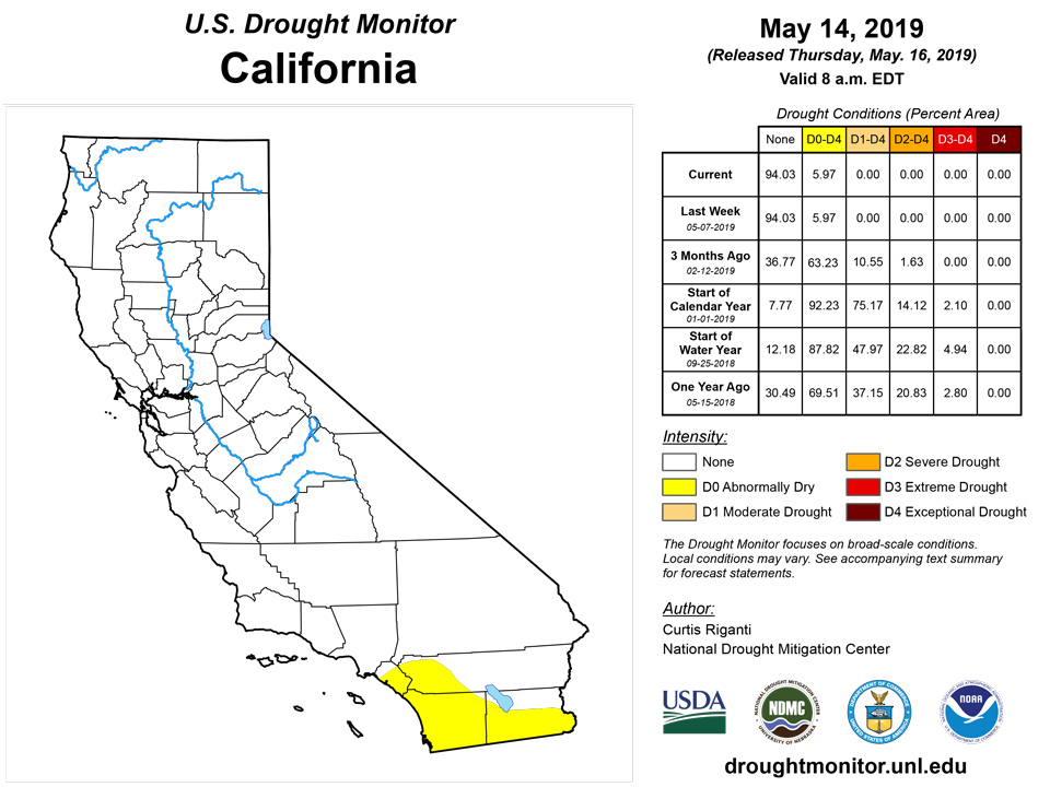
California and National Drought Summary for May 14, 2019
Summary
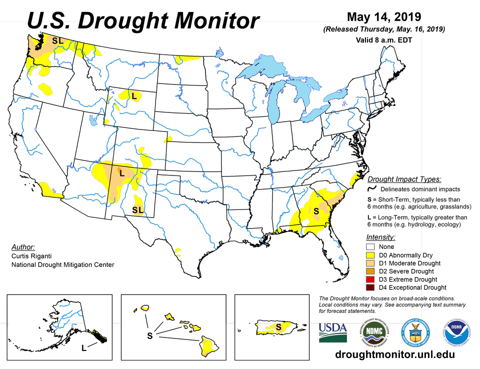
May 16, 2019 - Widespread precipitation this week led mostly to improvements in moderate drought and abnormally dry regions across the Southeast and South, and in the Rocky Mountains in southern Colorado and northern New Mexico. In parts of central and western Washington where high evaporative demand and paltry precipitation amounts continued, conditions degraded to moderate drought. Moderate and severe drought continued in southeast Alaska and in parts of Hawaii, while moderate drought and abnormal dryness coverage was adjusted in Puerto Rico.
Northeast
Widespread precipitation occurred in the region over the last week, keeping the region free of abnormal dryness or drought.
Southeast
Moderate to heavy rain engulfed much of the western Florida Panhandle and much of Alabama and southwest Georgia. As a result, short-term precipitation deficits were erased in many areas, leading to the removal of moderate drought that previously had extended from the Mobile area northeastward into southern Georgia. Some areas of abnormal dryness also improved in the Florida Panhandle, Alabama, and Georgia. Moderate drought was also removed in northeast Georgia and adjusted in parts of central and southern Georgia and South Carolina in response to changes in short-term precipitation deficits this week. The rest of the region remained free of abnormal dryness or drought.
South
Rainfall over the region was widespread and heavy in many areas, particularly Louisiana and southeast Texas, and this caused short-term precipitation deficits to improve in Texas and far southern Louisiana. Abnormal dryness in the Texas and Oklahoma panhandles was removed after rainfall this week. Abnormal dryness was also reduced and adjusted in southern Texas in response to recent rainfall. Abnormal dryness also ceased in southern Louisiana where heavy rainfall amounts of 3 to 5 inches were common this week.
Midwest
Light to moderate precipitation occurred over much of the Midwest, which was free of drought or abnormal dryness going into this week, and the region remains free of abnormal dryness or drought.
High Plains
Recent precipitation led to the removal of abnormal dryness in southeast Wyoming. Abnormally dry conditions continued from southwest Nebraska into northeast Colorado. Recent precipitation in the Wind River Range in Wyoming and improving surface moisture conditions led to a reduction of abnormal dryness in this area.
West
Precipitation over the past week in Colorado and New Mexico led to reduction of long-term precipitation deficits and improvement in conditions in southern Colorado and northern New Mexico. Moderate drought was completely removed from southern Colorado, and severe and moderate drought coverage was reduced in northwest New Mexico, where vegetation is prospering. A large area of long-term abnormal dryness also improved to normal conditions in south-central Colorado because of the continued precipitation. Abnormal dryness coverage in southwest Wyoming and northeast Utah was also reduced because of the effects of recent precipitation. Meanwhile, short- and long-term dry conditions, low streamflow, and high evaporative demand continue in western Washington, where moderate drought expanded to cover more of central and western Washington, including the coastal areas of the Olympic Peninsula.
Alaska, Hawaii, and Puerto Rico
Moderate drought continued in central Puerto Rico this week, though coverage was slightly reduced based on the location of short-term precipitation deficits. Abnormally dry conditions also expanded in southwest Puerto Rico. No changes were made this week in Alaska, and severe and moderate drought continued in southeast Alaska. Severe and moderate drought also continued on several islands in Hawaii, and no changes were made there this week.
Pacific Islands
The weather pattern during this USDM week (5/8/19-5/14/19) consisted of a couple weak circulations within a surface or near-equatorial trough across western (Yap State and Palau) to central (Kosrae to Chuuk States) Micronesia, trade-wind convergence over the Marshall Islands (RMI) and Kosrae State enhanced by the circulation (Invest 92W) which slowly moved across the eastern Federated States of Micronesia (FSM), and a dry trade-wind regime continuing across much of northern and western Micronesia. South of the equator, a northwest-to-southeast oriented surface trough remained nearly stationary near the Samoan Islands throughout the week. A surface low developed within the trough near the end of the week. This trough was a manifestation of the South Pacific Convergence Zone (SPCZ), with northerly winds to its north converging with southeasterly winds to its south. Satellite-based estimates of 7-day precipitation (QPE) showed a large area of 2 to 4+ inches of precipitation, with locally 10+ inches, across Kosrae to Pohnpei States associated with circulation 92W which tracked slowly across eastern FSM. A band of 1 to 2 inches of rainfall was indicated across parts of the RMI associated with the trade-wind convergence due to differential wind speeds. Small areas of 1-4 inches of precipitation were seen over parts of Palau and northwestern Yap State. Otherwise, little to no precipitation was indicated on the QPE maps for the rest of Micronesia. In the Southern Hemisphere, a large northwest-to-southeast region of 2-4 inches of precipitation, with locally higher amounts, stretched just north and east of the Samoan Islands, with its southern end engulfing American Samoa.
Extremely dry conditions persisted across the Mariana Islands, as weekly rainfall totals remained far below minimum requirements. During the first 2 weeks of May, passing showers delivered generally less than one-quarter inch of rainfall on Saipan, Rota, and at the Guam International Airport. According to the National Weather Service, "fuels remain dry [on Guam] and the Keetch-Byram Drought Index (KBDI) is now at 767 out of a maximum possible 800." The Guam International Airport received rainfall totaling just 0.10 inch (5 percent of normal) from May 1-14 and 2.06 inches (25 percent) from March 1 - May 14. As a result, short-term drought continues across the Mariana Islands, with exceptional drought (D4-S) on Saipan and extreme drought (D3-S) on Rota and Guam.
Some beneficial showers occurred across the Republic of Palau, with more than 2 inches of rain reported during the week at the Palau International Airport. Still, given the fact that Palau has not met its monthly minimum requirement of 8 inches since the beginning of the year, more sustained rainfall will be needed to reduce the intensity of severe drought (D2-S).
Varying degrees of drought continued across several of the northern and western islands in the Federated States of Micronesia. For example, moderate drought (D1-S) developed on Chuuk Lagoon, where rainfall during the first 13 days of May totaled just 0.74 inch. Meanwhile, Yap received 3.39 inches of rain from May 1-10, helping to reverse a drying trend and resulting in an improvement from extreme to moderate drought (D3-S to D2-S). Recent rainfall data for Ulithi was missing. Meanwhile, Pohnpei experienced short-lived dryness early in the month, with 3.15 inches falling from May 1-13. However, Pohnpei received 1.56 inches on May 14 and retains a D-nothing designation. Heavy rain has fallen in early May on several other islands, including Pingelap and Kosrae, leaving the remainder of the FSM free of dryness and drought.
Drought relief arrived in Majuro in early May, where 11.73 inches fell during the first 14 days of the month. By May 12, Majuro's reservoir storage rebounded to 33.96 million gallons, or 94 percent of capacity, which is above the critical threshold of 80 percent. As a result, Majuro's drought intensity was reduced from extreme to severe (D3-S to D2-S). Serious drought conditions persisted, however, across the northern Marshall Islands of Wotje and Utirik (both D4-SL), where little rain has fallen this year. Beneficial rain (more than 5 inches) fell on Kwajalein in the last week; however, given the antecedent dryness on that island -- with barely 2 inches of rain reported in March and April combined -- severe drought (D3-S) is retained, pending further assessment of the impact of recent showers.
American Samoa has been very wet in May, with 12.28 inches reported in Pago Pago through the 13th. As a result, there are no concerns about dryness and drought.
Looking Ahead
This week, a strong jet stream with several embedded storm systems will move into the continental U.S. and will interact with copious amounts of moisture. Though the evolution of each of the storm systems remains in question, moderate to heavy rain is possible in parts of the Great Plains and Midwest from this weekend into next week, including in areas that have received heavy rain recently, in addition to a risk for severe storms. Moderate to heavy precipitation amounts are also forecast in the Sierra Nevada and in some other parts of the West as the storm systems move from west to east. Warmer temperatures are forecast to occur in parts of the Southeast from this weekend into early next week.
Author(s):
Curtis Riganti, National Drought Mitigation Center
Brad Rippey, U.S. Department of Agriculture
Dryness Categories
D0 Abnormally Dry—used for areas showing dryness but not yet in drought, or for areas recovering from drought.
Drought Intensity Categories
D1 Moderate Drought
D2 Severe Drought
D3 Extreme Drought
D4 Exceptional Drought
Drought or Dryness Types
S Short-Term, typically less than 6 months (e.g. agricultural, grasslands)
L Long-Term, typically greater than 6 months (e.g. hydrologic, ecologic)
Source: National Drought Mitigation Center

