


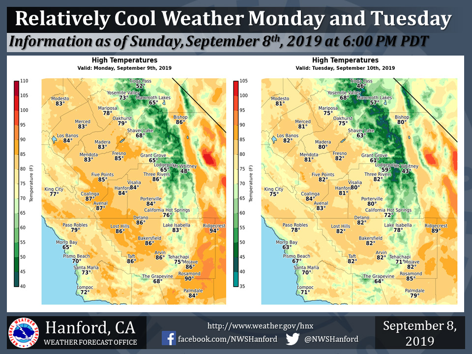
Mariposa projected high temperature for Monday: 78 degrees, Tuesday: 75 degrees
Oakhurst projected high temperature for Monday: 79 degrees, Tuesday: 75 degrees
Yosemite Valley projected high temperature for Monday: 73 degrees, Tuesday: 68 degrees
September 9, 2019 - The National Weather Service Hanford Office reports high temperatures Monday afternoon will be six to eight degrees below normal for this time of year.
Maximum temperatures Tuesday afternoon will be around ten degrees below their typical values for the first half of September.
  Area Forecast Discussion
  National Weather Service Hanford CA
  335 AM PDT Mon Sep 9 2019


  .SYNOPSIS...
  Below normal temperatures will continue through Wednesday then a
  warming trend will occur for the end of the week. Localy gusty
  winds will continue in the Kern County Mountains and Desert
  through Tuesday with breezy conditions elsewhere. Dry weather will
  continue with mostly clear skies through the upcoming week.

  &&

  .DISCUSSION...
  Sunny skies with below normal temperatures prevailed over the
  Central California Interior as winds diminished over a majority
  of the region. Support at the surface has weaken as surface
  pressure gradients from KSFO-KLAS relax and the Fort Ord Profiler
  shows a less defined marine layer. Yet, support aloft
  (synoptically) will continue a upper air analysis shows a weak
  trof pushing through Northern California during the day this
  Monday. Therefore, will maintain a forecast of high temperature
  about 10 degrees below their seasonal average values as many
  locations see highs in the mid 80s. In addition, due to the
  location of the passing trof, surface pressure gradients will
  remain below the criteria needed for another round of strong winds
  (wind advisory products). Therefore, light breezes expected
  during the next 24 hours period and will therefore cancel the wind
  advisory for Kern County this morning.

  Heading into the middle of the week, models continue to show the
  series of trof passages as a deeper trof digs into California on
  Tuesday. Model confidence therefore continue to grow on the
  solution of having a few disturbances cross the state ahead of a
  ridge pattern later in the week. While the first disturbance may
  only keep conditions steady, the second disturbance may allow for
  an additional push of marine air into the region along with
  stronger winds. Model surface analysis has the pressure gradient
  from KSFO to KLAS returning to values near 10mb on Tuesday. If the
  values is able to reach above 10mb, then will consider the
  issuance of another wind advisory for the Kern County area.

  Reaching toward the longer term, models attempt to introduce zonal
  flow pattern ahead of yet another trof passage next weekend. The
  zonal flow pattern is indicative of a steady state conditions with
  little rise in temperatures expected. Therefore, once the
  temperature begin to rise on Thursday, no addition rises will
  occur later on Friday or Saturday. By Sunday, the next trof begins
  to enter the region with the trof axis over California on Monday.
  While too far out to consider precipitation with any confidence,
  longer range model solutions do attempt to bring precip into
  Northern California. Will watch the next Monday period for model
  evolution as that period reached toward the short-term.
Source: NWS

