


Mariposa projected high temperature for Wednesday: 81 degrees, Saturday: 94 degrees
Oakhurst projected high temperature for Wednesday: 81 degrees, Saturday: 94 degrees
Yosemite Valley projected high temperature for Wednesday: 75 degrees, Saturday: 86 degrees
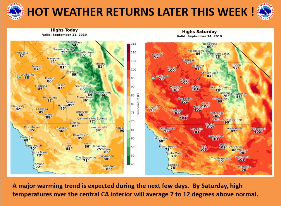
September 11, 2019 - The National Weather Service Hanford Office reports big warm up is in store for the central California interior for the remainder of this week.
High temperatures will reach the century mark over much of the San Joaquin Valley and the Kern County desert by Saturday.
  Area Forecast Discussion
  National Weather Service Hanford CA
  329 AM PDT Wed Sep 11 2019

  .SYNOPSIS...
  Dry weather will prevail over the district for the next
  7 days. A warming trend will bring temperatures to well
  above normal Thursday through Sunday. A return to breezy,
  much cooler weather is likely early next week.

  &&

  .DISCUSSION...An upper level trough that brought a preview of
  early Autumn weather to the central California interior the past
  few days is now exiting into the Great Basin. The onshore flow
  associated with this system is weakening and so are westerly winds
  through and below the Kern County mountain passes early this
  morning. Only a few locations are currently gusting to 45 mph in
  this region, so will let the wind advisory expire at 5 am PDT as
  planned.

  A major warming trend is in store for us during the next few days
  as a ridge of high pressure aloft gradually builds over the Golden
  State. Marine air that`s been pooled in the San Joaquin Valley
  will undergo some modification today as the onshore flow shuts off,
  but its presence will still keep high temperatures cooler than
  normal for one more afternoon. Otherwise, the warm up will begin
  in earnest over the higher terrain today. Hot weather will return
  to the San Joaquin Valley, lower foothills and the Kern county
  desert Thursday through the weekend as the high pressure ridge
  remains in control. Saturday will be the hottest day with a
  return of triple digit heat over much of the San Joaquin Valley
  and the Kern county desert. Even as early as Friday, thermometer
  readings could top the century mark in a few valley and desert
  locations. High temperatures will begin to ease back on Sunday
  as the high pressure ridge shifts eastward to the Four Corners
  region. By then, another upper level trough will be moving into
  the Pacific Northwest.

  This trough will bring a much cooler air mass into the central
  California interior early next week. As it approaches from the
  northwest Monday, the onshore flow will ramp up again and
  bring ocean cooled air back into the San Joaquin Valley and
  lower foothills. The cold front associated with this trough
  will move southward through the CWA Monday evening with little
  more than some cloudiness. Gusty winds with and behind this
  front could kick up some dust again in parts of the San Joaquin
  Valley and there could be a repeat of advisory level winds
  through and below the mountain passes Monday night through
  Tuesday evening. The models keep this trough moving progressively
  eastward and position it over the Great Basin by the middle of
  next week. Otherwise, high temperatures Monday through Wednesday
  will be a good 7 to 12 degrees cooler than normal.

  The bottom line is we`ll be in for a wild roller coaster ride
  with temperatures during the next 7 days. We`ll leave Autumn
  weather behind soon and see a return of Summer heat by the end
  of this week, then its back to the coolness of early Fall
  during the early to middle part of next week. Otherwise, dry
  weather will be the rule for the next 7 days.
Source: NWS

