


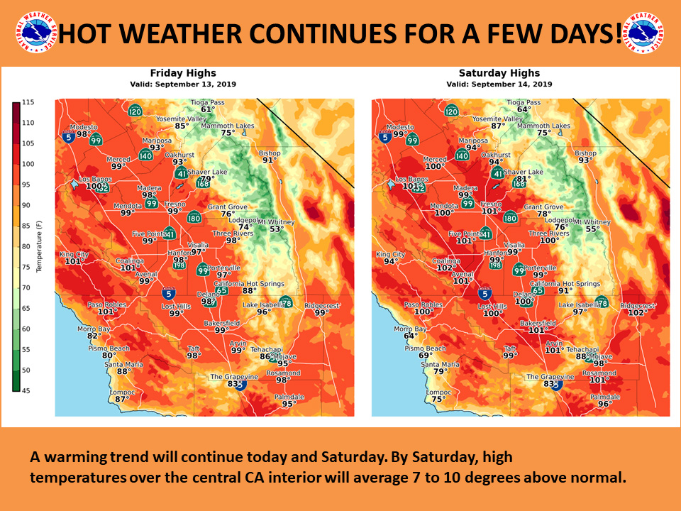
Mariposa projected high temperature for Friday: 93 degrees, Saturday: 94 degrees
Oakhurst projected high temperature for Friday: 93 degrees, Saturday: 94 degrees
Yosemite Valley projected high temperature for Friday: 85 degrees, Saturday: 87 degrees
Projected High Temp for Mariposa on Tuesday: 76 Degrees
September 13, 2019 - The National Weather Service Hanford Office reports temperatures will continue to trend upward across the area today and Saturday.
A cooling trend is expected to take place Sunday through Tuesday.
  Area Forecast Discussion
  National Weather Service Hanford CA
  248 AM PDT Fri Sep 13 2019


  .SYNOPSIS...
  A warming trend will continue into the weekend. High temperatures
  Friday and Saturday will be well above normal. Cooler and breezy
  conditions will return early next week with higher elevation
  precipitation possible and temperatures well below normal.

  &&

  .DISCUSSION...
  Flat ridge of high pressure in the upper levels is allowing
  temepratures to continue to rise today and Saturday. Most areas in
  the SJV will be in the upper 90s with a few locations near the
  major metropolitan areas reaching triple digits due to the heat
  island effect. The normal high temperatures for this time of year
  are in the lower 90s, so we will be experiencing above normal
  values today and Saturday with Saturday being the hottest day.

  A very impressive cold fall-like trough will dig south in the
  EPAC by Sunday into NORCAL from the Gulf of Alaska. The system is
  moisture starved and will bring light precipitation to the higher
  elevations of the Sierra with a few showers possible mainly north
  of Tulare County Monday night and Tuesday morning. Snow levels
  will start out around 9500 feet and lower to around 8500 feet
  before ending Tuesday morning. A light dusting to up to around 2
  inches is possible above 9000 feet in Yosemite NP. Light rain is
  possible in the SJV...mainly north of Fresno County. Trace amounts
  are expected in the SJV with up to 0.05 in the foothills.
  Eventhough this system is relatively dry, we will see a
  significant temperature change Monday and continue through the
  week next week. This will be our first taste of Fall as
  Temperatuers will drop some 8-15 degrees below normal for this
  time of year, with the coolest day being on Tuesday.

  Post frontal environment will be windy with strong gusty winds
  expected in Kern county and the Sierra high country on Tuesday. A
  secondary low pressure system will move into the PACNW on
  Wednesday and we can see continued unseasonably cool weather
  Wednesday and Thursday with clear skies and morning lows in the
  mid 50s in the SJV and around freezing above 8000 feet in the
  Sierra. After a long Summer, I am really looking forward to next
  weeks weather.
Source: NWS

