


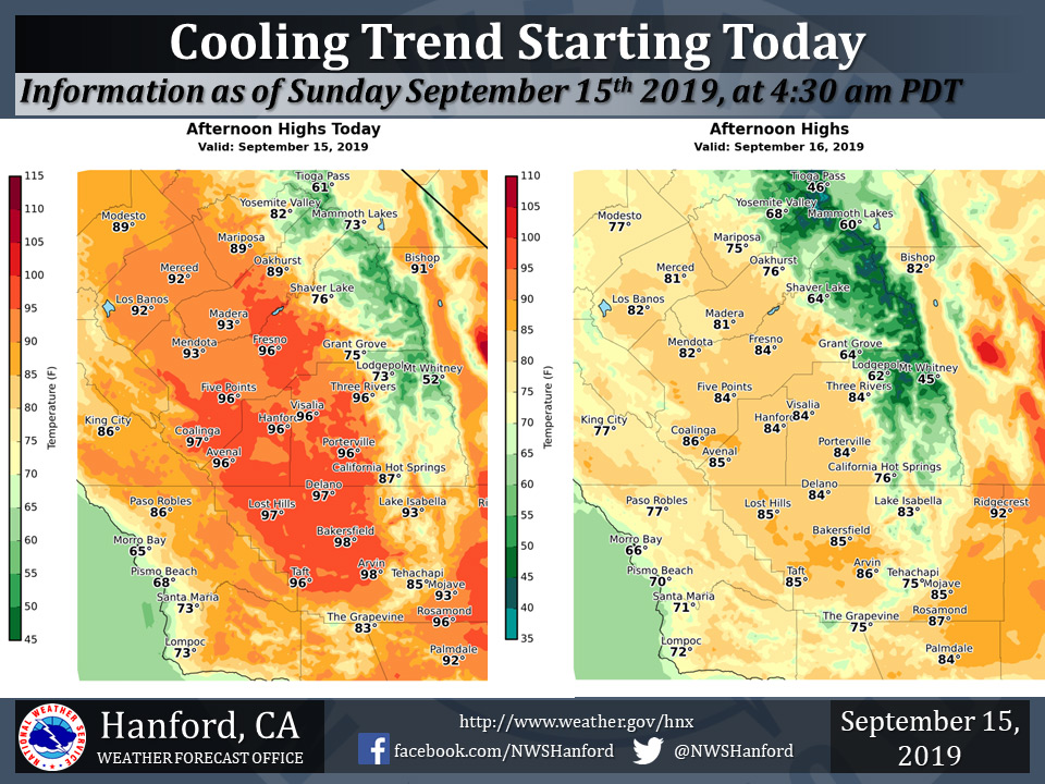
Mariposa projected high temperature for Sunday: 89 degrees, Monday: 75 degrees
Oakhurst projected high temperature for Sunday: 89 degrees, Monday: 76 degrees
Yosemite Valley projected high temperature for Sunday: 82 degrees, Monday: 68 degrees
September 15, 2019 - The National Weather Service Hanford Office reports much cooler weather is coming to Central California early next week!
High temperatures Monday afternoon will generally be five to eight degrees below normal for this time of year.
  Area Forecast Discussion
  National Weather Service Hanford CA
  310 AM PDT Sun Sep 15 2019

  .SYNOPSIS...Temperatures will continue to run warmer than normal
  over the central California interior today. Monday will be
  much cooler with a chance of showers north of Fresno county and
  mainly over the Sierra. Temperatures will then remain below normal
  for the remainder of the week.

  &&

  .DISCUSSION...The large upper ridge over the western CONUS that
  was responsible for the widespread triple digit heat across the
  San Joaquin Valley and Kern County Deserts on Saturday is now
  weakening as an upper trough takes aim at the PAC NW. IR imagery
  is indicating increasing high clouds pushing into central CA from
  the southwest. Fort Ord profiler is indicating a deepening marine
  layer which is now around 1500 feet deep. The combination of
  increased clouds and marine intrusions along with height falls
  will result in cooler daytime temperatures today although
  temperatures will remain above seasonal normals for one more day.

  SREF indicating the trough will move inland across the PAC NW and
  Norcal on Monday although the latest model runs are indicating
  that this system will not be as strong as previously advertised
  as a system behind it has been siphoning off some energy from it.
  This system will bring much cooler temperatures to our area with
  daytime highs across most of our area expected to be 10-15 DEG F
  lower than today. Some precipitation will also be possible with
  this system, mainly from Fresno County northward on Monday
  afternoon and evening. Most locations from Fresno County
  northward are expected to pick up between a trace to a few
  hundredths of an inch of rainfall with up to an inch of snow
  possible above 9000 feet in the Southern Sierra Nevada.

  Another impact from this system is that it will produce increased
  winds near the crest of the Southern Sierra Nevada on Monday
  afternoon and evening with local gusts as high as 75 mph. The SREF
  has backed off on winds over the Kern County Mountains and
  Deserts as the upper jet support remains further north. The trough
  is progged to move east into the Great Basin by Tuesday morning
  giving way to decreased winds and another relatively mild day
  across our area.

  The medium range models are now trending stronger with another
  trough that will push across Norcal on Wednesday Night and
  Thursday. This will bring another round of increased winds to our
  area along with a slight chance of precipitation to the Yosemite
  area. This system will also bring another surge of cooler air to
  our area and keep temperatures below seasonal normals through the
  end of the week even as our area dries out again on Friday and
  Saturday.
Source: NPS

