


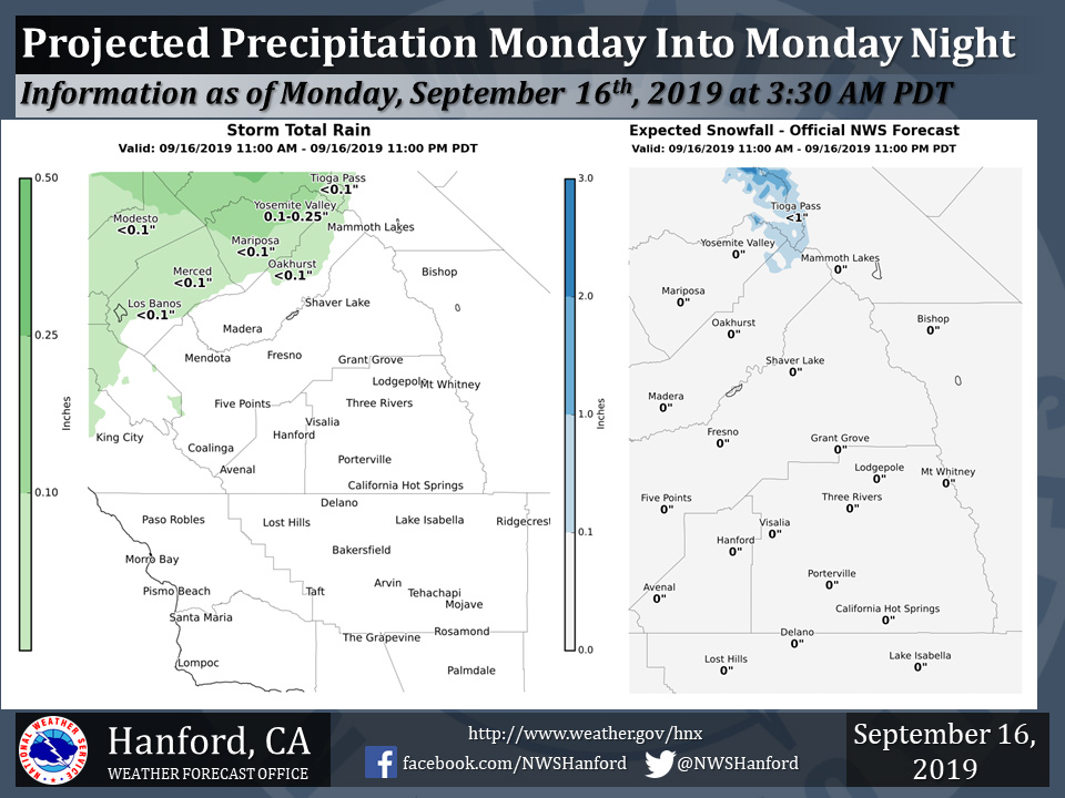
Mariposa and Oakhurst possible rainfall of less than 0.10".
Yosemite Valley possible rainfall of 0.10" to 0.25".
Updated Monday Morning
September 15, 2019 - Light rain and high elevation snow is expected, north of Fresno County, this afternoon and evening.
Precipitation amounts in the northern portion of the San Joaquin Valley will be light.
The majority of this precipitation will fall this afternoon.
  Area Forecast Discussion
  National Weather Service Hanford CA
  224 AM PDT Mon Sep 16 2019


  .SYNOPSIS...
  Significant cooling trend today as trough of low pressure ushers
  in cooler air. There is a chance of afternoon thunderstorms in
  the Sierra Nevada today near Yosemite NP; some snow showers may
  occur along the higher elevations of the Sierra Nevada as well.
  Another trough arriving Wednesday night/Thursday will keep
  Central California in the high 70s/low 80s before another warming
  trend this weekend.


  &&

  .DISCUSSION...
  Incoming trough of low pressure will lead to much cooler weather
  across the San Joaquin Valley this afternoon with afternoon highs
  expected to be 12-15 degrees cooler compared to yesterday. As the
  trough moves inland, a few light rain showers may occur in
  northern Merced and Mariposa county this afternoon. Also this
  afternoon, some instability associated with cooler air aloft may
  help trigger a rumble or thunder or two in the Sierra Nevada near
  Yosemite National Park. Along with a slight chance of
  thunderstorms, a few light snow showers may occur this
  afternoon/evening with snow levels around 8500-9500 feet. A surge
  of stronger winds across the forecast area with the incoming
  trough are forecast to occur this afternoon and evening. A few
  wind gusts around 20-25 mph are possible this afternoon/evening in
  the SJ Valley, which could cause some blowing dust in the western
  portion of the valley. Stronger gusts of 45-55 mph are possible
  in Kern County just below the mountain passes. Therefore, a Wind
  Advisory will be in effect this afternoon starting at 2 PM through
  11 PM tonight for the Lake Isabella/Tehachapi area, Indian Wells
  Valley, and the Mojave Desert.

  Tuesday will be a couple of degrees cooler throughout the
  forecast area, with afternoon highs progged to be in the 80-82
  degree range with zonal flow aloft ahead of the next disturbance.
  Dry weather expected Tuesday through midday Wednesday, then
  slight chance showers near Yosemite NP in the Sierra Nevada as the
  upper trough begins to impact the region. Models are showing a
  chance of precipitation occuring throughout the day on Thursday
  across the Sierra Nevada, and a few of these showers may produce
  flurries above 8500 feet. Strong winds through the Sierra Nevada
  may occur with the passage of this trough, and some gusty winds
  may also occur in the SJ Valley/Kern passes Wednesday night into
  Thursday. After the trough exits the district, models begin to
  diverge on the upper air pattern somewhat, but general thinking is
  that a warming trend will occur starting Friday into this
  weekend.
Source: NWS

