


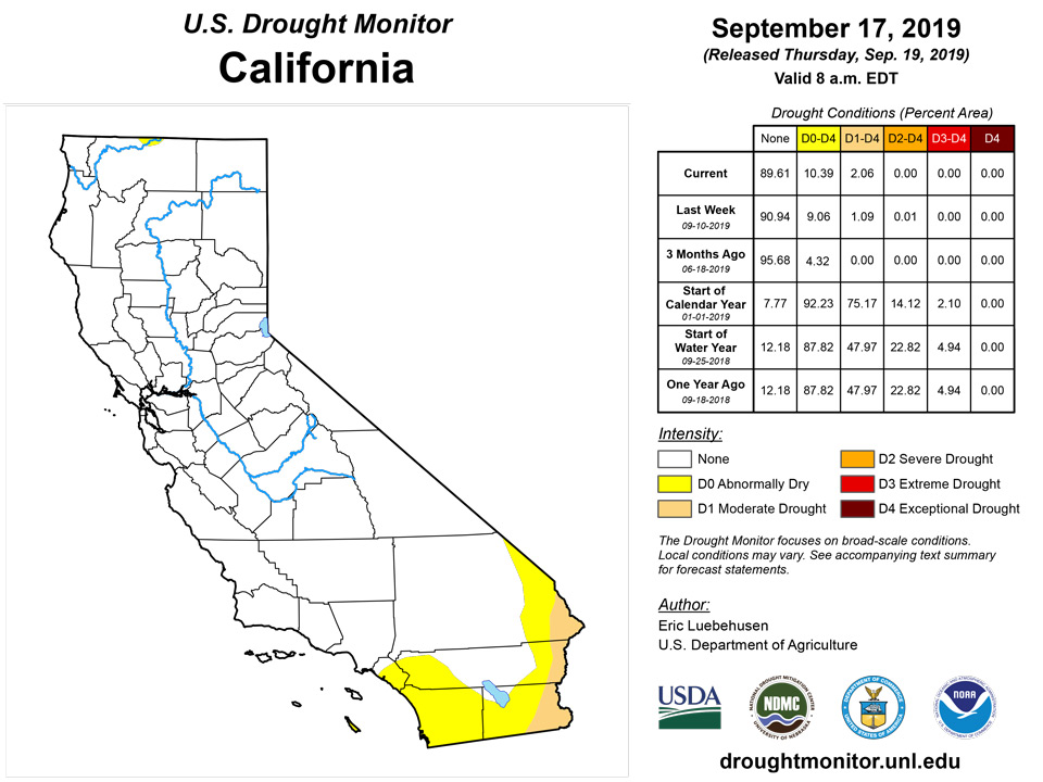
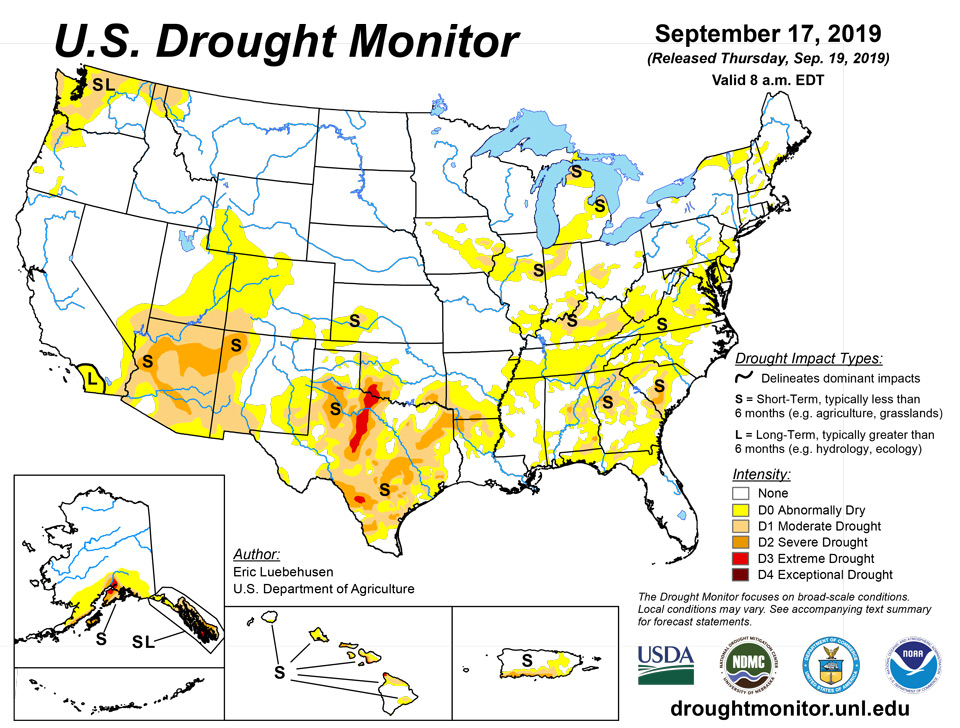
California and National Drought Summary for September 17, 2019
Summary
September 19, 2019 - Rapidly intensifying “flash drought” — attributed in part to extreme late-summer heat — continued to afflict many areas from the lower Midwest and Mid-Atlantic States to the Gulf Coast. Likewise, an abysmal Southwestern monsoon (to-date) led to increasing drought intensity and coverage in Arizona, while short-term drought persisted across the Hawaiian Islands. Conversely, moderate to heavy rain eased or alleviated dryness and drought from the Great Lakes into the Northwest as well as in southwestern Alaska and southern Puerto Rico.
Northeast
Early-week heat (temperatures as high as the lower 90s) and locally acute short-term rainfall deficits (30-day rainfall totaling 10 to 25 percent of normal) led to the expansion of D0 (Abnormal Dryness) across West Virginia, Maryland, Delaware, as well as southeastern Pennsylvania and the southern two-thirds of New Jersey. Similar pockets of Abnormal Dryness were noted in southern New England.
Southeast
Intense late-summer heat and acute short-term dryness led to a sharp increase in drought intensity and coverage. Excessive heat (95-101°F) and pronounced short-term rainfall deficits (30-day rainfall totaling less than 25 percent of normal) heightened evapotranspiration rates and soil moisture losses, resulting in quickly escalating drought impacts (often referred to as a “flash drought”.) It should be noted that “flash drought” often occurs more quickly (in terms of impacts) than the data indicates. For this weeks’ analysis, the expansion of D0 (Abnormal Dryness) and Moderate Drought (D1) was driven by guidance from local experts, impact reports from observers, as well as temperature- and rainfall-driven data products which focused on the past 30 to 60 days. Increases in D0 and D1 were most pronounced in northern portions of the region (from northern Alabama into central North Carolina) as well as from the Florida Panhandle into southern Georgia. State-wide average topsoil moisture was rated 73 percent short to very short (according to USDA-NASS) as of September 15 in both Georgia and Alabama, and 83 percent short to very short in Virginia.
South
As with the Southeast, intense late-summer heat and acute short-term dryness led to a sharp increase in drought intensity and coverage across central portions of the region. Excessive heat (95-102°F) and pronounced short-term rainfall deficits (30-day rainfall totaling locally less than 10 percent of normal) heightened evapotranspiration rates and soil moisture losses, resulting in quickly escalating drought impacts (often referred to as a “flash drought”.) It should be noted that “flash drought” often occurs more quickly (in terms of impacts) than the data indicates. In terms of temperatures, Wednesday, September 18th marked the 18th consecutive day of 90-degree heat at Little Rock, Arkansas (the long term historical total-September average is 9 days); September 18th also marked the 7th day with 100-degree readings at Meridian, Mississippi (only one other year—1980—had this many, and only 7 other years total had 3 or more (records dating back to 1889)). For this weeks’ analysis, the expansion of D0 (Abnormal Dryness) as well as Moderate (D1) to Extreme Drought (D3) was driven by guidance from local experts, impact reports from observers, as well as temperature- and rainfall-driven data products which focused on the past 30 to 60 days. Increases in drought were most pronounced from central and northeastern Texas into the central and northern Mississippi Delta, where 60-day rainfall has totaled a meager 25 percent of normal or less. State-wide average topsoil moisture was rated more than 70 percent short to very short (according to USDA-NASS) as of September 15 in the Mississippi Delta States, and 83 percent poor to very poor in Texas (tied for second highest in the nation with Virginia, only 2 percentage points behind California’s 85 percent). Despite the generally dry, hot weather pattern, heavy showers and thunderstorms (2-4 inches) provided highly localized drought relief across southeastern and north-central Texas as well as western Oklahoma. After the end of the monitoring period (12z Tuesday), heavy showers associated with the remnants of Tropical Storm Imelda were bringing rain to southeastern Texas; the impacts of this rainfall will be incorporated in next week’s U.S. Drought Monitor.
Midwest
Reductions to drought intensity and coverage across the northern half of the region contrasted with rapidly intensifying and expanding drought in the south. From Minnesota and northern Iowa into Wisconsin, Michigan, and northern Illinois, widespread soaking rainfall (1-6 inches, locally more than 8 inches) eased or eradicated lingering Abnormal Dryness (D0) and Moderate Drought (D1). Conversely, temperatures in the middle and upper 90s coupled with acute short-term moisture deficits (30-day rainfall locally less than 25 percent of normal) led to an expansion of D0 and D1, most notably from southern Illinois eastward into Kentucky and neighboring portions of Indiana and Ohio. State-wide average topsoil moisture was rated more than 40 percent short to very short (according to USDA-NASS) as of September 15 in Indiana and Ohio, and 78 percent poor to very poor in Kentucky. Reports from the field indicate Kentucky is experiencing the same type of “flash drought” being observed across much of the south; the impacts of “flash drought” often occur more quickly than the objective data indicates.
High Plains
Widespread moderate to heavy rain (1-6 inches, locally more than 8 inches) over the northern half of the region contrasted with pockets of dryness and drought in the southern and western High Plains Region. The rain eliminated the last vestiges of Abnormal Dryness (D0) in North Dakota and eastern Nebraska. Conversely, input from local experts as well as 60-day rainfall locally less than 50 percent of normal led to a minor expansion of D0 and Moderate Drought (D1) in southwestern Kansas. The rest of the region remained unchanged and largely devoid of dryness concerns, though D0 and D1 remained in place over western and southeastern portions of Colorado as well as southwestern Wyoming.
West
An abysmal Southwestern monsoon contrasted with increasingly wet weather in the Northwest. The Southwestern monsoon, which typically runs from June 15-September 30 and accounts for up to half the total annual precipitation in some parts of the Southwest, has featured less than 50 percent-of-normal rainfall (locally less than 30 percent). While showers over the past week in New Mexico (1-3 inches, locally more) helped stem the recent trend toward increasing drought in the east, rain bypassed most of Arizona. Input from local experts as well as mounting 6-month rainfall deficits supported an expansion of Severe Drought (D2) in the driest locales of southern and central Arizona.
Farther north, moderate to heavy rain fell for a second consecutive week from the Pacific Northwest into the northern Rockies, with the highest totals (2 inches or more) observed on the windward slopes of the mountains. This pushed two-week totals to locally more than 4 inches, spurring additional reductions of Abnormal Dryness (D0) as well as Moderate to Severe Drought (D1-D2). Reductions to D0 in the eastern Great Basin were spurred by input from local experts, who indicated a lack of any lingering impacts due to a recent uptick in precipitation in northeastern Utah (locally more than 2 inches over the past two weeks).
Alaska, Hawaii, and Puerto Rico
The recent trend toward wetter weather continued in Alaska, with this past week featuring 1 to 4 inches of rain over many of the state’s primary drought areas. 7-day rainfall totaled as much as 3.5 inches and 4.2 inches on the Alaska and Kenai Peninsulas, respectively, with two-week rainfall in excess of 6 inches locally. While more rain will be needed to fully eradicate the Alaska’s Moderate to Extreme Drought (D1-D3), the recent wet weather has eased the drought coverage and intensity somewhat. In Hawaii, portions of the Big Island and Maui remained very dry. Reports from the field indicated many pastures aren't usable despite enough rain recently to encourage green up. In Puerto Rico, heavy rain during the past week (2-6 inches, locally more) continued to eat away at the northern edge of the island’s southern drought areas, though steamflows remained very low (below the 10th percentile) along the south coast of Puerto Rico.
Pacific Islands
Short-term abnormal dryness continued this week in American Samoa. At Pago Pago, 0.53 inches of rain fell, bringing the monthly total to 1.78 inches. At Siufaga Ridge, 1.03 inches fell, and 0.44 inches fell at Toa Ridge.
No dryness is taking place in Palau, where 6.87 inches of rain has fallen in September so far, which is already above the 5.9-inch normal for the month.
In Saipan, 6.31 inches of rain fell on Sept. 16, so no dryness is occurring there. On Rota, the last three weeks and months have received rainfall well above their respective cutoffs; 8.24 inches of rain fell there this week, with one day of data missing, bringing the September total to 12.3 inches. The last three weeks and months in Guam have also received sufficient precipitation, where weekly rainfall was 9.23 inches (with one missing day), which brought the monthly total to 13.09 inches.
Conditions over the last month and a half on Yap have been sufficiently wet; 11.58 inches of rain fell in August, and with 5 missing days of data this week, 4.7 inches of rain had fallen so far in September. Sufficient rainfall in August and during two of the last three weeks on Woleai maintained wet conditions there, though five days of data were missing this week. Data in Fananu was missing this week, but non-drought conditions continued here, given the 20.33 inches of rain in August and 10.33 inches of rain in September. Only 0.83 of rain has fallen at Chuuk Lagoon this week, with one day of missing data, but 13.99 inches of rain has already fallen in September. In Lukunor, sufficient rainfall from June to August and three of the last four weeks maintained a lack of dryness here. Two days of data were missing from Nukuoro this week, where 0.6 inches of rain had fallen, but August had 13.77 inches of rain and September has reached 4.02 inches. No rain was recorded through five recorded days this week on Kapingamarangi, but 5.04 inches so far in September precluded a change to short-term abnormal dryness. Rainfall on Pohnpei has been high on most recent time scales, where 7.34 inches of rain has fallen this week (with two days of missing data). Short-term dryness on Pingelap improved to normal conditions this week; 3.5 inches of rain (with two days missing) combined with 7.8 inches of rain in September sufficiently improved the drier short-term conditions. Rainfall on Kosrae continued to be sufficient, with 2.78 inches of rain this week (with two missing days) and 9.73 inches through September. Missing data in Ulithi precluded assigning a drought depiction there this week.
In Kwajalein, sufficient rainfall in August, combined with 2.56 inches of rain this week and 6.04 inches through September combined to continue normal conditions there. In Ailinglapalap, a few recent weeks have received below threshold rainfall, but August received sufficient rainfall and 4.35 inches of rain has fallen so far in September, so normal conditions continued here this week. On Jaluit, severe drought continued on both the short- and long-term; 0.55 inches of rain had fallen so far (with two days of missing data this week), bringing the September total to 2.76 inches. Abnormally dry long-term conditions continued on Utirik, where most months from November 2018 to July 2019 received less than half of their rainfall thresholds, but where rainfall in August and September has been higher. Short- and long-term moderate drought continued on Wotje, where January-June monthly precipitation totals all fell below half of their respective thresholds, and 0.94 inches of rain fell this week. Normal conditions continued on Majuro this week, where 3.33 inches of rain fell this week. 0.67 inches of rain fell in Mili this week (with two days of missing data), leaving September totals at 3.55 inches. However, the 16.27 inches of rain in August precluded the development of abnormally dry conditions here.
Virgin Islands
Abnormal dryness continued this week on St. Croix, where a blend of one- to 12-month SPI suggested long-term abnormally dry conditions. Less rain fell this week in St. Thomas, but abnormal dryness was not occurring there.
Looking Ahead
An active weather pattern will foster periods of moderate to heavy rainfall from the southern Plains into the Midwest, while intermittent rain and mountain snow linger from the Pacific Northwest into the northern Rockies. Meanwhile, moisture associated with the remnants of Tropical Storm Imelda will fuel locally heavy showers in southeastern Texas and the western Delta. Some late-season monsoon showers are also possible in the Four Corners Region, though the heaviest rain may stay east of the region. Despite the stormy weather pattern, little—if any—rain is expected across the Southeast, with only light showers in the offing farther north in the Mid-Atlantic and Northeastern States. The NWS 6- to 10-day outlook for September 24–29 calls for above-normal temperatures along the central California Coast and from the Rockies to the East Coast; cooler-than-normal weather will be confined to the Northwest and lower Southwest. Near- to above-normal precipitation across much of the nation will contrast with drier-than-normal conditions from the Southeast into the Mid-Atlantic States.
Author(s):
Curtis Riganti, National Drought Mitigation Center
Dryness Categories
D0 Abnormally Dry—used for areas showing dryness but not yet in drought, or for areas recovering from drought.
Drought Intensity Categories
D1 Moderate Drought
D2 Severe Drought
D3 Extreme Drought
D4 Exceptional Drought
Drought or Dryness Types
S Short-Term, typically less than 6 months (e.g. agricultural, grasslands)
L Long-Term, typically greater than 6 months (e.g. hydrologic, ecologic)
Source: National Drought Mitigation Center

