


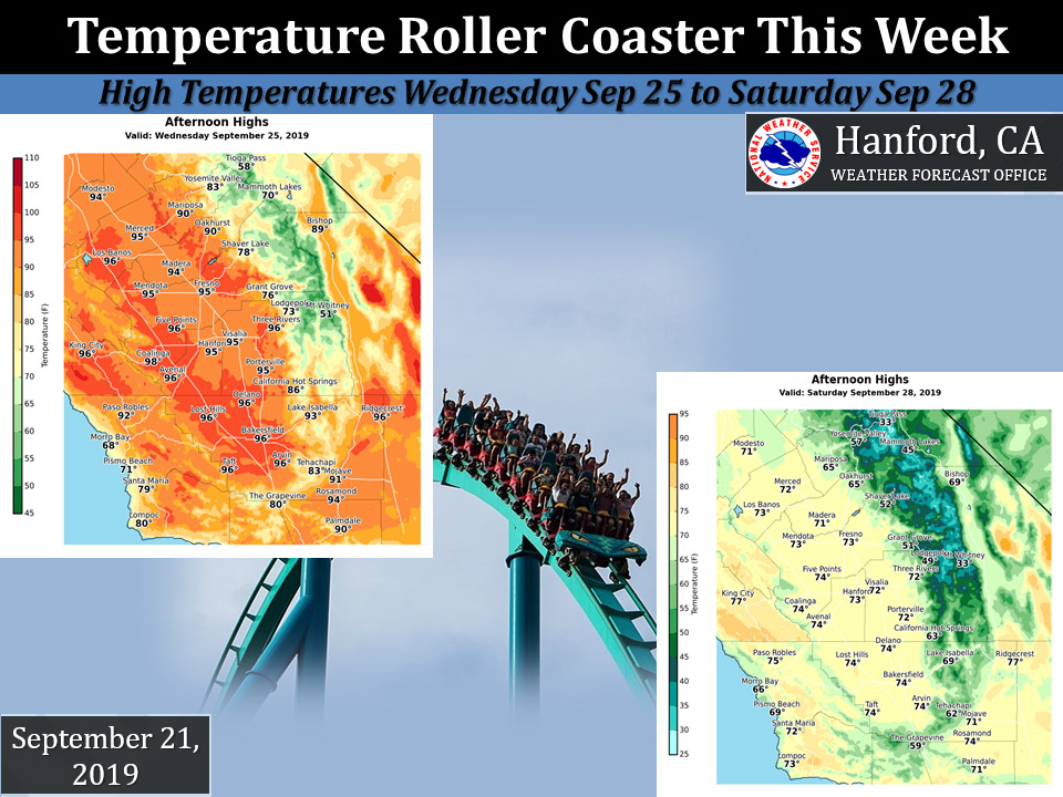
Mariposa projected high temperature for Wednesday: 90 degrees and Saturday: 65 degrees
Oakhurst projected high temperature for Wednesday: 90 degrees and Saturday: 65 degrees
Yosemite Valley projected high temperature for Wednesday: 83 degrees and Saturday: 57 degrees
September 22, 2019 - National Weather Service Hanford Office reports and increasing likelihood of a major pattern change coming next weekend.
Nearing 100F in the valley Wednesday, then maybe only 70s in the valley next Saturday.
  Area Forecast Discussion
  National Weather Service Hanford CA
  400 AM PDT Sun Sep 22 2019

  .SYNOPSIS...Dry weather can be expected over the district
  through Thursday. Temperatures will warm to seasonable
  levels today then trend slightly cooler Monday in the wake
  of a dry cold front. A major warm up will occur by midweek
  with high temperatures near the century mark Wednesday in
  the hottest locations of the San Joaquin Valley and desert.
  A cold storm system will bring a change to unseasonably cool
  and possibly wet weather Friday through next weekend.

  &&

  .DISCUSSION...The week ahead will bring some wild temperature
  swings in addition to some astounding weather extremes. One
  week from today many of us may look back in amazement and wonder
  how we could transition from Summerlike heat during midweek to
  unseasonably cool, unsettled weather at the end of the week and
  possibly Winterlike conditions over the high Sierra by next
  weekend. We`ll do our best to sort it all out for you in this
  discussion.

  Today, officially, is the last day of Summer. Thermometer readings
  will climb above the 90 degree mark in the San Joaquin valley,
  lower foothills and the Kern county desert this afternoon as a
  weak ridge of high pressure aloft moves over central California.
  When Fall officially arrives at 12:58 am PDT Monday, a cold front
  will be approaching from the northwest. This moisture starved
  front will sweep southward through our CWA Monday morning with
  little more than some mid and high clouds. In its wake, the rest
  of Monday will be breezy and slightly cooler than today with
  seasonable afternoon temperatures.

  A much stronger upper level ridge anchored over the Eastern
  Pacific will build into central California Tuesday through
  Wednesday and bring a major warming trend. High temperatures
  Tuesday will bounce back above the 90 degree mark in the San
  Joaquin Valley and the Kern county desert. As the ridge gains
  stronger footing over central California Wednesday, temperatures
  will soar well into the 90s in the valley and desert. Thermometer
  readings could top the century mark in the hottest locations.
  That`s pretty close to the records in Fresno and Bakersfield.
  (The record high in Fresno for Wednesday is 100 degrees which
  last occurred on that date in 2009.  In Bakersfield, the record
  high for September 25th is 103, which last occurred on that date
  in 1975.)  This might be Summer`s last hurrah before a storm
  system in the Gulf of Alaska chases it all away later this week.

  That storm will be a major pattern breaker when it arrives here
  Friday. As the cold front ahead of this storm approaches from
  the north on Thursday, the high pressure ridge will get squashed
  and there will be an increase in onshore flow across central
  California. A shallow intrusion of marine air will come into
  at least the northern half of the San Joaquin Valley by Thursday
  afternoon and lower high temperatures back to seasonable levels.
  Otherwise, Thursday will still be slightly warmer than normal
  over much of the CWA.

  That cold front will slip south of our CWA Thursday night and
  herald the arrival of a much cooler air mass Friday. Otherwise,
  the upper level trough that follows this cold front will deepen
  along the West coast Friday through Saturday. In doing so, our
  weather will turn sharply cooler/colder and the atmosphere will
  become increasingly unstable over the central California interior.
  Showers will become likely over the mountains Friday and could
  materialize over the lower elevations by Friday afternoon or
  evening. As the upper level trough moves inland Saturday, rain
  showers could turn to snow showers in the Sierra above 7,000
  feet and isolated thunderstorms equipped with small hail could
  develop over the San Joaquin Valley and adjacent foothills
  Saturday afternoon, especially from Fresno county northward.
  Isolated funnel clouds are certainly possible on Saturday as
  well. Afternoon temperatures Friday and Saturday may be no
  higher than the lower 70s in the San Joaquin Valley and possibly
  as cool as the mid 60s. (Records for low max temperatures could
  be challenged in the San Joaquin Valley both days depending on
  cloud cover.)

  The models differ on the placement and the depth of this upper
  level trough along the West coast next weekend, so forecast
  confidence is low as to where and how much precipitation occurs
  over the CWA. The GFS continues to deepen the trough over the
  Golden State next Sunday while the ECM displaces the closed low
  off the Pacific Northwest coast and places much of central CA
  under a relatively drier southwesterly flow aloft. Whatever
  the case, our pattern looks potentially wet by Saturday,
  especially over the mountains. Hikers and campers in the Sierra
  will want to pay close attention to NWS forecasts during the later
  part of the week and be prepared for a drastic change to wintry
  weather by next weekend with the potential for several inches of
  snow in the Sierra above 8,000 feet.
Source: NWS

