


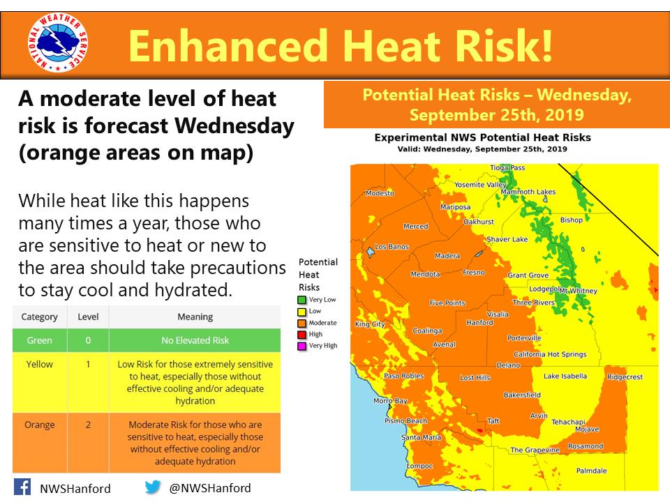
Mariposa County Potential Heat Risk for Wednesday ranges from Moderate in the lower elevations to Low in the higher elevations.
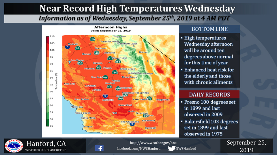
September 25, 2019 - The National Weather Service Hanford Office reports high temperatures Wednesday afternoon will be near the daily records for maximum temperatures ever observed in Fresno and Bakersfield on September 25th.
Temperature records at Fresno date back to 1888. Temperature records at Bakersfield date back to 1893.
  Area Forecast Discussion
  National Weather Service Hanford CA
  404 AM PDT Wed Sep 25 2019


  .SYNOPSIS...
  Dry weather and well above normal temperatures will continue through
  Thursday. A significant day to day cooling trend will occur Friday
  through next Monday and may be accompanied by showers over the
  Sierra and adjacent foothills this weekend.

  &&

  .DISCUSSION...
  We are a couple of days into Autumn but currently experiencing a
  period of hot and dry summer like conditions. Temperatures will
  trend further upward today and highs are expected to top out
  around 8-12 degrees above climo, more typical of late July/early
  August rather than late September. This warmup is being aided by
  an offshore flow regime between high pressure building in from
  the north and an upper level low spinning near northern Baja.
  After near record highs today, a change in the synoptic pattern
  will start us on a path to more fall like conditions.

  Models prog the northern Baja low to lift out after today while a
  developing low pressure system drops south through the Pacific
  Northwest by the end of the week. Conditions Thursday will be
  less hot, but still warmer than seasonal averages in weakening
  offshore flow during the transition of the pattern.

  Significant cooling will then commence for the end of the week
  into the start of next week as the developing low pressure trough
  continues to drop southward. Temps Friday will at or slightly
  below climo and by Sunday we`ll see highs as much as 10 to 15
  degrees below normal. This system has some moisture with it, and
  will bring a chance for showers over the Sierra and adjacent
  foothill zones Saturday through Monday. A bit of accumulating snow
  will be possible over the high Sierra during the period. Total
  amounts should be no more than a couple of inches at the highest
  elevations.

  Though other areas in central CA are expected to remain mainly
  dry, blended model guidance does allow for a possibility of light
  showers along the east side of the SJ Valley up against the
  foothills with the passing system this weekend. Increasing gusty
  winds will be the more significant impact outside the Sierra zones
  over the weekend, especially through the mountain passes and into
  the desert areas of Kern County on Saturday.

  As the trough pulls away after Monday, temperatures will recover a
  bit into the middle of next week but still remaining several
  degrees below climo.
Source: NWS

