


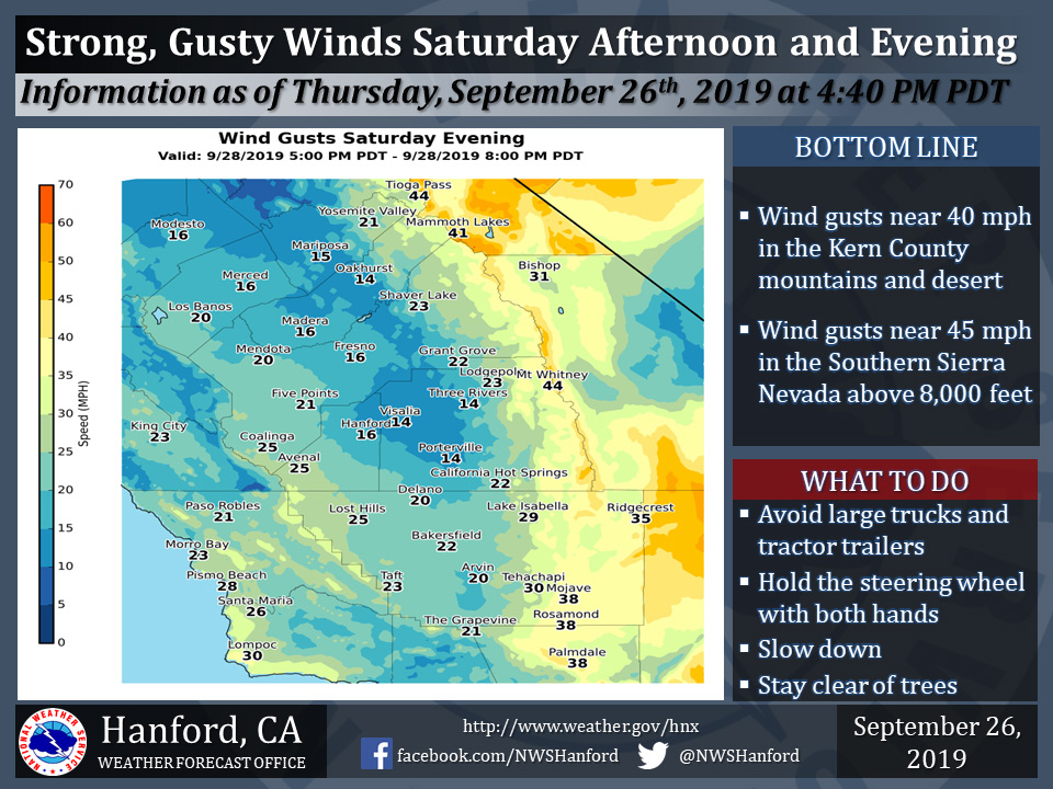
Possible wind gusts up to 15 mph for Mariposa, 14 mph for Oakhurst and 21 mph in Yosemite Valley for Saturday afternoon and evening.
September 27, 2019 - The National Weather Service Hanford Office reports strong, gusty southwest to west winds are likely in the Southern Sierra Nevada, Kern County mountains, and Kern County desert Saturday afternoon and Saturday evening.
Robust wind gusts may blow down tree branches and power lines. A few power outages are possible. Travel will be difficult, particularly for high profile vehicles.
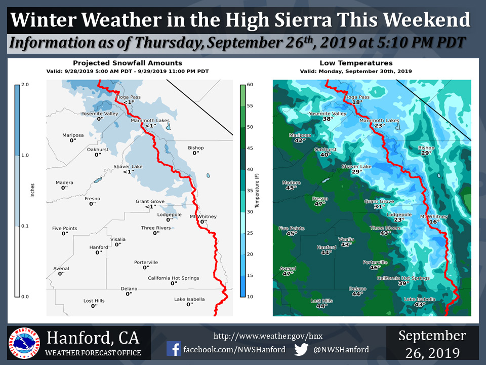
One to two inches of snow is possible in the higher elevations of the Southern Sierra Nevada this weekend.
Snow levels will begin at around 8,000 feet Saturday, before falling to about 6,000 feet Sunday.
Mountain campers and hikers along the Pacific Crest Trail should take precautions and prepare for cold weather this weekend.
Area Forecast Discussion
  National Weather Service Hanford CA
  211 AM PDT Fri Sep 27 2019

  .SYNOPSIS...
  A cold front will move into and across the area tonight
  and Saturday bringing cooler air, an increase in wind and
  a chance of precipitation to mainly the Sierra and foothill
  area through the weekend. A large area of low pressure will
  then linger over Northern California and the Pacific
  Northwest through early next week keeping temperatures below
  normal.

  &&

  .DISCUSSION...
  Nothing but clear skies early this morning over the Central
  California Interior as high pressure holds on. Things will change
  later today and tonight as satellite imagery shows the incoming
  cold front now just pushing southward from Oregon into Northern
  California.

  The two most notable changes for today will be a pronounced
  cooldown and an increase in wind. Temperatures today will be
  about 10-15 degrees cooler than Thursday`s highs and these values
  will be just below normal for late September. This afternoon, as
  onshore pressure gradients increase, winds will become stronger
  and gusty through passes and advisory level winds may be realized
  through Pacheco, Cottonwood and other passes over the west side of
  the forecast area.

  For tonight and Saturday, as the front pushes south, forecast
  models bring the parent low pressure system southward from
  Washington into Oregon and heights fall over the entire west as
  colder air aloft arrives. Additional cooling of another 8-10
  degrees will be common over the area and with enough instability
  arriving, rain showers and higher elevation snow showers will
  begin over the Sierra and foothill areas.

  By Sunday, the low reaches its farthest south and westward
  position over southern Oregon and this will likely be the period
  of best threat of rain and snow over the Sierra. Compared to
  middle of winter standards, this systems precipitation threat is
  small however for late September snow in the Sierra and its higher
  elevation activities along the Pacific Crest Trail and camping
  interests, will feel a major impact. Snow may fall to as low as
  5500-6000 feet however accumulations will be a big curiosity as
  they could reach 1-3 inches in places. Lower elevation folks will
  certainly feel the affects of highs barely reaching 70 degrees in
  most places. It will certainly feel like fall, well a least for a
  couple of days.

  Models keep the low and deep trough over the region through
  Monday, then lift the system east on Tuesday with a quick ejection
  into the plains on Wednesday. This will allow for dry and warming
  weather over the forecast area. Although it will be warmer next
  week, no real big heating up is anticipated as a weak, baggy
  trough is progged to remain over California.
Source: NWS

