


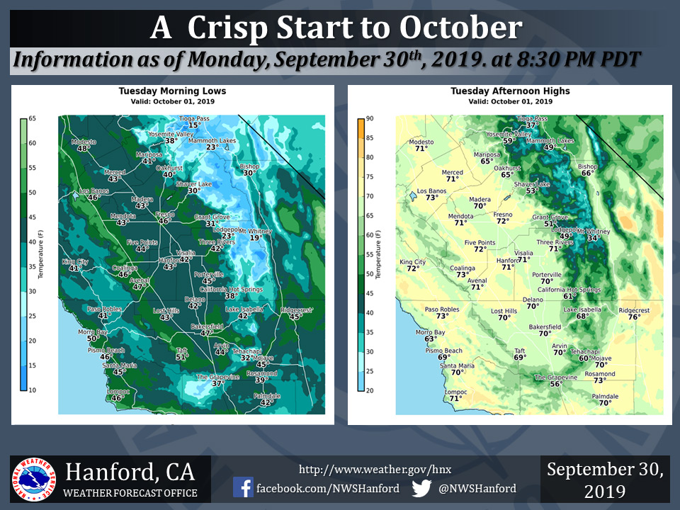
Mariposa projected high temperature for Tuesday: 65 degrees
Oakhurst projected high temperature for Tuesday: 65 degrees
Yosemite Valley projected high temperature for Tuesday: 59 degrees
October 1, 2019 - The National Weather Service Hanford Office reports we will usher in October with continued below normal temperatures and dry, clear conditions.
  Area Forecast Discussion
  National Weather Service Hanford CA
  304 AM PDT Tue Oct 1 2019

  .SYNOPSIS...
  Dry weather will prevail over the district for the next week.
  Temperatures will average much cooler than normal Tuesday. Day to
  day warming thereafter will bring temperatures to seasonable
  levels or slightly higher by Sunday and continue through Monday.

  &&

  .DISCUSSION...
  Large scale positively tilted trough from Idaho extending
  southwest into California is providing the region with high
  temperatures normally seen in late October into early November.
  The pattern will be slow to break down as a large scale upper
  level ridge of high pressure has parked over the SE US providing
  them with record high temperatures over the past few days.

  The upper level cold low center over Idaho will lift out into the
  Northern Plains by Wednesday. However, another strong cold low
  pressure center will drop south into the PACNW by Thursday
  afternoon from the Gulf of Alaska and will provide our region
  with continued below average temperatures into Saturday now. We
  had been advertising a warmup to above average temperatures by
  late in the week, but that has been moved back into the weekend.
  We will see slightly above normal temperatures Sunday into Monday
  as a weak upper level ridge of high pressure builds into the
  region by Sunday. The Low center will move out of the PACNW and
  dig into the eastern US as it breaks down the ridge which will
  retrograde into NRN Mexico and build into California on Sunday.

  Dry weather is expected into early next week across the CENCAL
  Interior.
Source: NWS

