


Temperatures slightly above normal, especially across inland areas.
Chance of a delayed start to the “rainy season” with a high likelihood of below normal rainfall this winter, overall.
Near normal to slightly above number of offshore wind events expected through December.
Weather Discussion
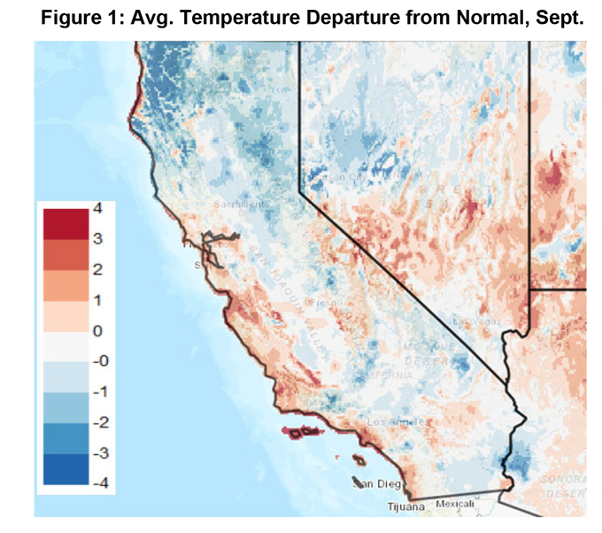
October 2, 2019 - After a rather hot and dry August, the weather in September turned noticeably cooler (Figure 1, below). Several unseasonably deep troughs from the Pacific
 Northwest passed through California in September, which led to widespread wetting rains over Northern CA and much cooler weather over Southern CA. The first significant offshore wind event since last December occurred on the 23rd of August when some wind gusts to 45 mph were recorded in the higher mountain elevations of Southern CA. However, the event was localized and mainly confined to the upper mountain elevations (large diameter fuel model beds) and no large fires resulted from the gusty winds. Light rains occurred in the Sierras and periods of drizzle fell further south, resulting in light wetting rains during the last weekend of September. But all precipitation received in September was far too light to change fuel moisture conditions appreciably in the long term.
With September in the rear-view mirror but the bulk of the “offshore wind season” ahead of us, there remains considerable uncertainty with regards to how the overall weather pattern may evolve this winter. There has been much vacillation in the long term models over the past month, which may be partially attributed to a lack of a durable sea surface (SST) distribution across the Pacific.
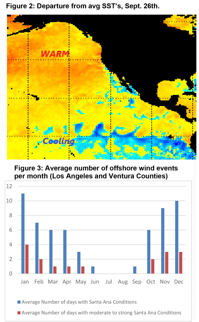
Last month, SST’s were reflective of a negative Eastern Pacific Oscillation and a negative North American Oscillation. This month’s two week outlooks are indicating a reverse trend. In a similar fashion, most ENSO model predictions were calling for SST anomalies to remain around 0.5 above normal last month, but recent trends the past two weeks indicate the opposite case seems to be evolving (Figure 2, below).
It is difficult to judge whether the lack of consistency in the models and their seemingly poor alignment to current weather events are due to rapid changes in SST’s or some other reason. But overall model confidence is lower than usual heading into fall this year. Other recent years have had a clearer signal as to whether the coming fall/winter would be dry or wet, but this year’s tendency has been to align well with one signal before reversing to opposite. In short, none of this lends a great deal of confidence in the long-term models so far this fall.
That being said, as long as the jet stream remains active, there may be a high frequency of troughs reaching the West Coast and the Pacific Northwest. However, since SST’s are uniformly warm over the Gulf of AK, there may be a weakening of the jet followed by a northward migration later this fall. This may keep the storms weaker and further north compared to what we’ve seen so far this year. Some long term models seem to align with this notion; the IMME, GEM, Canadian and NASA models all depict below normal precipitation for October – December, while the NCEP (domestic) models stand with a contrary, minority opinion.
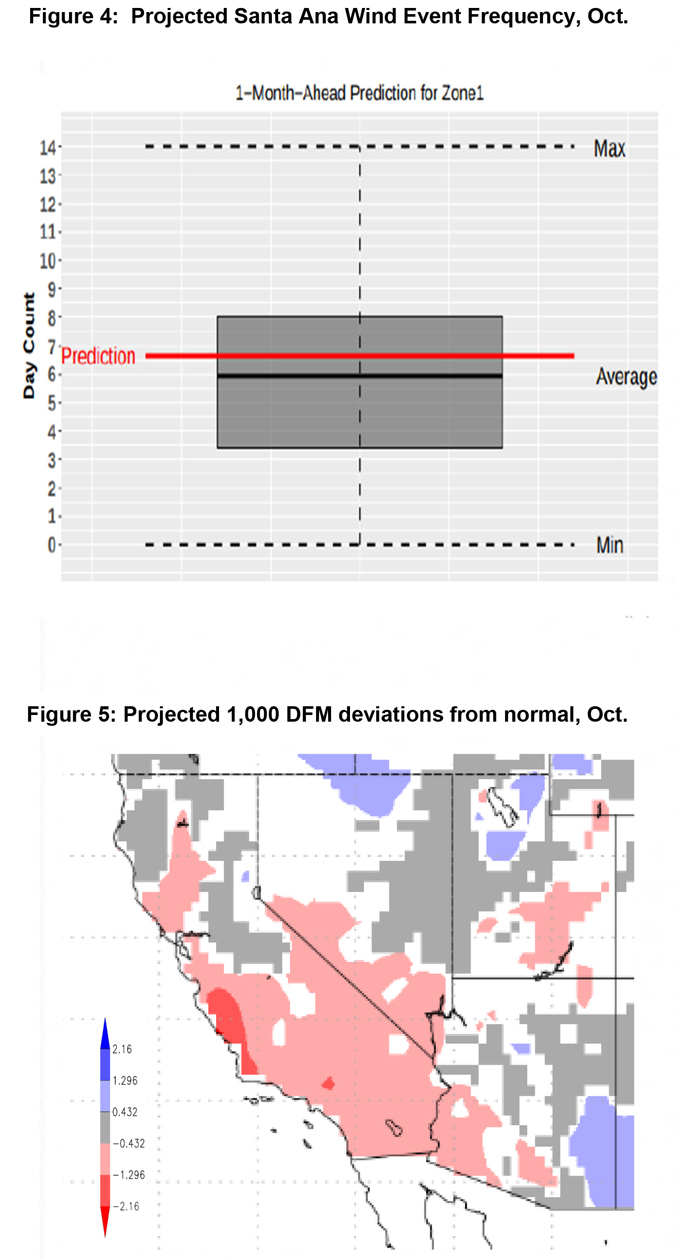
Local office studies in cooperation with some of our weather partner’s research indicates there may be a near to slightly above normal number of offshore wind events this fall (Figure 5, below). The study in question attempts to predict the number of offshore wind events given the current ENSO, PNA and EPO. The past two years’ forecast showed at least a weakly positive correlation between the number of predicted offshore wind events vs the number of actual events. This year, in the study’s third season of availability, it will be interesting to see if the near normal prediction verifies since there are few clear-cut signals to better gauge this fall’s expected weather.
FUELS AND DROUGHT OUTLOOK
Hot, dry conditions in August and the first part of September caused fuel moisture conditions to drop steeply during the past few weeks. The “cushion” that live fuels had been showing of above normal fuel moisture from last winter’s rains has seemingly disappeared and fuel moisture conditions are trending fairly close to average for this time of year. Dead fuels are a bit drier than average and live fuels are trending pretty close to critically dry levels, so both live and dead fuels will carry fire without hesitation. Fires will grow rapidly during especially hot or windy periods, at least until winter rains arrive.
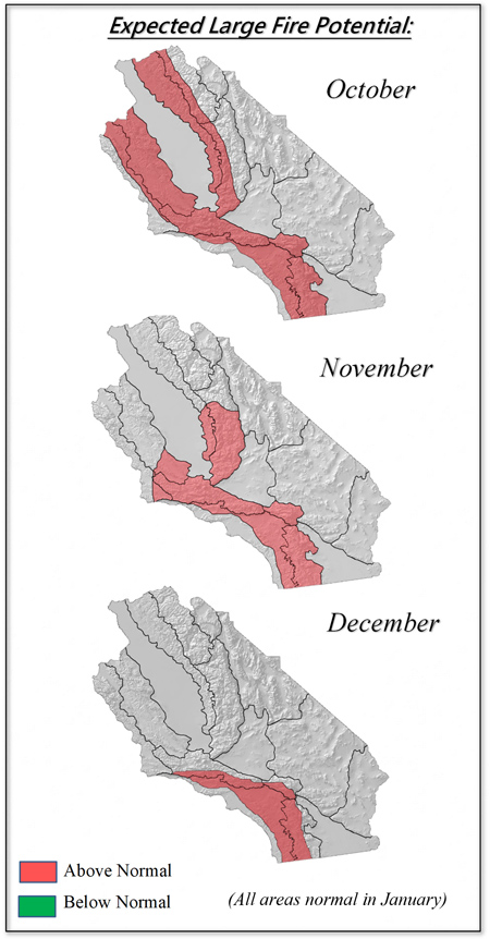
Since there is a slight majority of long-range models are forecasting below average precipitation this fall/early winter, large fire potential is expected to remain slightly above normal through the fall months into the first part of winter. Large fire potential will likely be highest in the coastal areas which are prone to offshore winds. The number of such events is expected to be close to normal (Figure 3, previous page) – but even a normal number of windy days would be significantly higher than last fall when very few offshore wind days were experienced.
Looking ahead to the winter, there is a growing consensus that this winter may end up being drier than normal. The precipitation deficits this winter may be highest over Southern California with less severely dry conditions across Central CA. Should this prove to be the case, there will likely be drought conditions across part, or perhaps nearly all, of the Geographic Area emerging in the spring. There may also be less water available in reservoirs going into 2020 if snowpack is below normal this year. If this winter ends up being drier and warmer than normal spring, (as suggested by more than one model) the long respite from fires that we saw last December - April is unlikely to repeat this coming winter.
Source: Predictive Services

