


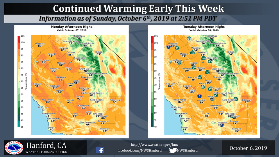
Mariposa projected high temperature for Monday: 86 degrees, Tuesday: 84 degrees
Oakhurst projected high temperature for Monday: 86 degrees, Tuesday: 84 degrees
Yosemite Valley projected high temperature for Monday: 78 degrees, Tuesday: 76 degrees
October 7, 2019 - The National Weather Service Hanford Office reports temperatures will remain relatively warm early this week.
On Monday, highs will be around 4 to 8 degrees above normal for early October, with readings around 90 degrees in the warmest locations.
Expect similar or slightly lower temperatures on Tuesday.
  Area Forecast Discussion
  National Weather Service Hanford CA
  312 AM PDT Mon Oct 7 2019


  .SYNOPSIS...
  Ridge across the district will keep temperatures above normal
  today into Tuesday. A cold front will move through the area on
  Wednesday, significantly lowering temperatures and increasing the
  chance for strong winds in the Kern County mountains, desert, and
  valley. This front will also increase the fire weather risk in
  the Kern County mountains beginning Wednesday into Friday.
  Temperatures will remain near to slightly below average through
  the end of the forecast period. Conditions will remain dry for the
  next seven days.


  &&

  .DISCUSSION...
  Sunday`s temperatures across the central California interior
  warmed as much as 8 DEG F as the high pressure ridge continued to
  build in the region. Short-term model consensus shows this
  warming trend will continue today into Tuesday as the high
  pressure ridge remains the dominate feature. High temperatures
  will warm an additional 3-6 DEG F both days, ended up 5-10 DEG F
  above normal. Although quite warm for for the date, neither Fresno
  nor Bakersfield will be close to record territory. An area of
  concern today is a heightened fire weather risk in Sequoia
  National Forest of Tulare County into the Kern County mountains
  due to low humidities, dry fuels, and locally gusty winds.

  The big change to our pattern will arrive on Wednesday as a
  trough begins to dig into the northern Great Basin. This will push
  a cold front through the district, dropping afternoon high
  temperatures up to 10 to 15 DEG F compared to the beginning of the
  week. Models keep this system very dry, so there is no chance of
  precipitation. The main concern will be strong winds into the Kern
  County mountains and desert, as well as into the valley. Both the
  GFS and ECMWF have the SFO-LAS pressure gradient increasing to
  around 13mb, thus these areas will have to be watched for possible
  wind products on Wednesday, possibly even Thursday. Additional
  impacts with the strong winds will be first be blowing dust into
  the valley. The second area of concern will be the heightened risk
  of fire weather conditions in the Kern County mountains,
  especially from late Wednesday into Friday. This is because long-
  term models show a significantly drop in RH values and when
  combined with dry fuels and gusty winds fire weather will be of
  concern during this time frame.

  Heading into the end of the forecast period, temperatures will
  remain near average as longer-term models keep a zonal flow
  across the area. Conditions will remain dry for the next 7 days.
Source: NWS

