


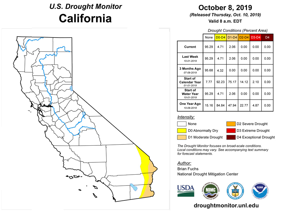
California and National Drought Summary for October 8, 2019
Summary
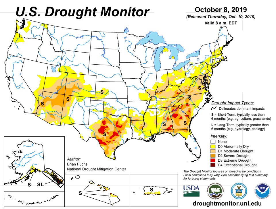
October 10, 2019 - The flash drought in the southern portions of the United States, especially over the Southeast and Texas, remains the prominent feature this week. As conditions continue to dry out coinciding with record warmth, deteriorations are widespread and rapidly occurring. Temperatures were varied over the United States this week, and much of the West, upper Midwest, and central and northern Plains were cooler than normal, with temperatures 3 to 6 below normal widespread. It was even cooler over Great Basin with temperatures 6 to 9 degrees below normal. In contrast, temperatures over the Southeast were generally 9 to 12 degrees above normal coming off a month when many locations set records for the warmest September on record. Temperatures were generally 6 to 9 degrees above normal in Texas and into the Midwest as well. Two prominent rain events came through the country in the last week. The first occurred at the beginning of the period when much of eastern New Mexico, west Texas and the Texas panhandle received rain and thunderstorms. A significant rain event moved through the southern Midwest and into the South, not only putting a stop to further drought development but also allowing for widespread improvements. Unfortunately, these rains did not get into the Southeast, where another hot and dry week continues to raise havoc on the region, especially to those involved in agriculture.
Northeast
Temperatures were mixed this week. In the north, temperatures were cooler than normal with departures of 2 to 4 degrees below normal, and in the south, temperatures were normal to above normal with departures of 3 to 5 degrees above normal. Precipitation was greatest over much of central and western Pennsylvania, New York, northern Vermont, New Hampshire and southwest Maine. Outside of these areas, conditions remained dry for the week, with below-normal precipitation. Improvements to the abnormally dry conditions were made in New York, Vermont, New Hampshire and Maine. In the Mid-Atlantic, moderate drought was expanded in central Maryland, northeast Virginia, south central Pennsylvania, and Delaware. Abnormally dry conditions were also expanded in Delaware. Improvements were also made over western portions of West Virginia.
Southeast
The flash drought continued to rapidly impact the region with both above-normal temperatures and below-normal precipitation. Florida and Alabama had their third warmest September on record, South Carolina their fourth and Georgia their fifth. Alabama, Georgia and Florida all had their driest September on record. From areas in Alabama, Georgia, north Florida and the Carolinas, a widespread full category degradation again took place this week with even more widespread severe and extreme drought conditions being depicted from a week ago. Abnormally dry conditions were added in eastern Virginia. Some rains in the Florida peninsula allowed for no changes farther into Florida this week, but conditions there also remain drier than normal. Portions of northern Alabama did receive enough precipitation to show some improvements and slow some of the drying out in areas that did not get enough rain for improvements to take place.
Midwest
Temperatures were cooler than normal over the upper Midwest with departures of 3 to 6 degrees below normal while the southern and eastern portions of the region had above-normal temperatures with departures of 6 to 9 degrees above normal. Ohio had their warmest September ever while Kentucky and Missouri had their second warmest ever. Kentucky also had their driest September ever while Illinois had their 25th wettest September ever. Significant rain came through the region and allowed for several improvements, but the areas that missed these rains in southern Illinois, southern Indiana, and Ohio continued to dry out, especially with the warmer than normal temperatures. Abnormally dry conditions were eliminated in northern Illinois and into northern Indiana. Moderate drought was improved over the “thumb” of Michigan while some of the newly introduced (last week) abnormally dry conditions in southern Missouri were improved this week. A full category improvement was made to drought conditions over much of Kentucky and the southern edges of Illinois, Indiana, and Ohio.
High Plains
Cooler than normal temperatures and the first freeze for the season were widespread throughout the region. Temperatures were 3 to 6 degrees below normal for most of the area. Above-normal precipitation was recorded over much of the Dakotas, eastern Nebraska and most of Kansas. Drier than normal conditions were reported over Colorado, western Nebraska, and southwest South Dakota. The region had abnormally dry conditions expand over eastern Colorado and slight improvement to the abnormally dry conditions over western Wyoming.
South
Mississippi had their driest September on record and Tennessee had their second driest while Texas and Louisiana had their warmest Septembers. Oklahoma, Arkansas, and Mississippi had their second warmest. Significant rains over portions of west Texas and into the panhandle, northern Arkansas, southern Arkansas and northern Louisiana as well as much of western Tennessee allowed for some improvements in the region. Abnormally dry conditions were removed over much of the Texas panhandle and into west Texas. Moderate drought was also improved upon over the far northeast portion of the Texas panhandle and into western Oklahoma. A full category improvement was made over southern Arkansas and into northern Louisiana. A full category improvement was made in western Tennessee, northern Mississippi, and northern Alabama where the greatest rains fell. In the areas not impacted by rain, the warmer than normal temperatures along with dry conditions allowed for the flash drought to continue. Widespread degradations were made over Texas where areas of severe and extreme drought were expanded greatly. In central and southern Louisiana, abnormally dry conditions spread southward while a new area of moderate drought was introduced over eastern Mississippi.
West
Cooler than normal temperatures dominated the region, with areas of Idaho, Nevada, Oregon, and Utah having temperatures 6-9 degrees below normal. Warmer than normal temperatures were experienced in New Mexico, where departures were 3 to 6 degrees above normal. Precipitation was widespread through central and eastern New Mexico and spotty throughout the Pacific Northwest and northern Rocky Mountains. The precipitation in New Mexico did allow for a full category improvement to the abnormally dry conditions in the southeast, east, and southwest portions of the state. In Arizona, further assessment of last week’s rain was done, with some further improvements made. Moderate drought and severe drought conditions were improved slightly in the central to south central portions of the state where the greatest impacts of the previous rains were observed. Due to a recent wet pattern, moderate drought and abnormally dry conditions were improved over the panhandle of Idaho, northeast Washington and northwest Montana.
Alaska, Hawaii, and Puerto Rico
In Hawaii, the islands had a mix of improvements and degradations. On Kaui, abnormally dry conditions were removed. For Oahu, improvements were made to both the abnormally dry and moderate drought conditions. On Lanai, a full category improvement was made and on Maui, there was an improvement to the extreme drought from Ulupalakua to Wailea. The Big Island saw a mix of improvements and worsening, as mostly more moderate drought was introduced and a pocket of abnormally dry conditions was removed. No changes were made in Puerto Rico or Alaska this week.
Pacific Islands
The weather pattern during this USDM week (10/02/19-10/08/19) was dominated by a modest monsoon trough across northern portions of Micronesia with several weak or broad circulations or tropical disturbances embedded within it from the Marianas to the northern Marshall Islands (RMI). One of the circulations slowly developed into Tropical Depression 20W as it moved westward. After 20W reached tropical storm (Hagibis) strength north of Pohnpei State, Hagibis rapidly intensified into super-typhoon status and moved across the Marianas at the end of the week. A high pressure ridge was over southern portions of Micronesia at first, with areas of convergence developing as the week progressed. An upper-level trough north of eastern Micronesia spread upper-level divergence over the RMI which enhanced rainfall. South of the equator, a high pressure ridge dominated American Samoa's weather for most of the week.
Satellite-based estimates of 7-day precipitation (QPE) showed a band of 4+ inches of rain across northern Micronesia along the monsoon trough and path of STY Hagibis, with 1+ inches extending south into northern and eastern portions of the Federated States of Micronesia (FSM) and parts of the RMI. Less than an inch of rain was indicated by the QPE across Palau, southern portions of the FSM, and parts of the RMI. Areas of 1-4 inches of rain were estimated from the QPE west and north of the Samoan Islands, with very little rain indicated across American Samoa.
For Guam and the Commonwealth of the Northern Mariana Islands (CNMI), weekly precipitation totals (ending October 9th) include 5.84 inches at Guam, 4.66 inches at Rota, and anywhere from 5.73 - 9.01 inches at Saipan (ASOS reported 5.73 inches, NPS reported 7.95 inches, and a manned gauge reported 9.01 inches with one day missing). The eye of super-typhoon Hagibis passed just north of Saipan on October 7/8, sparing the island of 150 mph winds (gusts to 185 mph). The CNMI and Guam did however receive plenty of rain with this super-typhoon, as evident from the rainfall totals noted above. Given the proximity of this tempest to the CNMI and Guam, there is no reason to change the current drought designation ("D-nothing") in this region. Especially impressive with Hagibis was the rate at which it intensified, from tropical storm strength to super-typhoon status in about 24 hours.
The International Airport in Palau reported 2.01 inches of rain this week, which exceeds the 2-inch weekly threshold for fulfilling most water requirements in this area. Palau’s drought designation remains D-nothing. According to the NWS Forecast Office in Palau, Koror’s (preliminary) year-to-date rainfall total stands at 94.32 inches, and the normal for this period is 115.20 inches. This places Koror’s rainfall total to date at 81.9 percent of normal.
Last week across the southern Federated States of Micronesia (FSM) Lukunor, Nukuoro, Woleai, and Kapingamarangi were set to D0(S), after several weeks of insufficient rainfall totals (<2 inches per week) for meeting most water needs. Rainfall accumulations this week include 0.86-inch (Yap, 2 days missing), 1.13 inches (Woleai, 2 days missing), 1.20 inches (Chuuk, 1 day missing), 0.32-inch (Lukunoch, 2 days missing), 1.20 inches (Nukuoro, 1 day missing), 1.52 inches (Kapingamarangi), 5.14 inches (Pohnpei), 2.20 inches (Pingelap), and 3.99 inches (Kosrae). The last 3 stations over eastern portions of the FSM received in excess of 2 inches of precipitation this week, which is more than enough to meet most water needs. For the remaining 6 stations noted above, the drought designations also remain unchanged this week. No data is available for Ulithi and Fananu.
For the Republic of the Marshall Islands (RMI), weekly rainfall totals include: 4.54 inches at Majuro, 4.42 inches at Mili, 2.50 inches at Utirik, 1.30 inches at Ailinglapalap, 0.81-inch at Kwajalein, 0.67-inch at Wotje, and 0.27-inch at Jaluit. Both Majuro and Mili have already more than doubled the weekly minimum threshold of 2 inches per week to meet most water needs. Drought designations remain unchanged this week across the RMI. Jaluit continues to have the driest conditions, and is categorized as D2(SL). The last month in which Jaluit’s rainfall total exceeded the 8-inch monthly minimum threshold was back in March, when it received 8.74 inches.
In American Samoa, Tutuila experienced a dry August and a dry September, and that dry trend continues through the first week of October. At Pago Pago, only one week in the last 7 has been wet, with 0.15-inch of rain being reported this past week. This weekly accumulation falls far short of the 2-inch weekly minimum requirement to meet most water needs. Two automated high-elevation stations (Toa and Siufaga ridges) report rainfall amounts this week of 0.24-inch and 0.59-inch, respectively. Therefore it seems that a one-category deterioration is warranted in Tutuila this week, from D0(S) to D1(S).
Virgin Islands
No changes were made to the drought depictions across the U.S. Virgin Islands this week. According to the NWS Forecast Office in San Juan, Puerto Rico, the Cyril E. King Airport in St. Thomas reported 0.04-inch of rainfall during this past drought week. Observed rainfall amounts since September 1st and January 1st are 3.55 inches (51.4 percent of normal) and 26.48 inches (97.9 percent of normal), respectively. Data from the CoCoRaHS station at Anna’s Retreat (VI-ST-1) indicated 0.02-inch of rain during the past week, and a total of 2.44 inches of rain since the start of September. Despite very short-term declines in well levels, the Grade School-3 Well level remains high, having received a boost from late-summer/early-autumn tropical showers. For Charlotte Amalie, SPI values at 1 (-0.54), 3 (+1.04), 6 (+0.16), 9 (-0.71), and 12 (-0.14) months support drought-free conditions.
The Henry E. Rohlsen Airport in St. Croix reported 0.02-inch of rain during the past week. Observed rainfall amounts since September 1st and January 1st are 1.90 inches (31.4 percent of normal) and 18.38 inches (70.2 percent of normal), respectively. The CoCoRaHS station at Christiansted (VI-SC-8) indicated a trace of rain this past week, and a total of 6.28 inches since September 1st. Groundwater levels at the Adventure 28 well continued to be low as of October 8, following a general decline that began in late 2018. For Christiansted, SPI values at 1 (-0.91), 3 (-0.04), 6 (-0.06), 9 (+0.10), and 12 (-1.37) months are mixed, with several values representative of D0 to D2 drought. Accordingly, St. Croix’s drought designation may need to be downgraded to D0 next week.
According to data provided by a volunteer observer, Windswept Beach on St. John’s received 0.45-inch of rain during the past week. The year-to-date accumulation for this location is 28.47 inches, which is 91.3 percent of normal. Similar to the situation on St. Thomas, the USGS well on St. John’s also benefitted from tropical showers during the late-summer/early-autumn period, although the water level is still about a foot below the land surface. SPI values at 1 (-0.48), 3 (+0.47), 6 (+0.21), 9 (-0.25), and 12 (+0.07) months are supportive of drought-free conditions.
Looking Ahead
Over the next 5-7 days, precipitation chances look to be greatest over the Plains and Midwest and into the Mississippi Valley. The greatest chances of precipitation are in North Dakota and through Missouri into Oklahoma. Conditions are expected to remain dry over much of the West, Southwest, and Mid-Atlantic into the Southeast. Cooler than normal temperatures are projected over most of the country with the greatest departures expected over the High Plains, where departures could be over 20 degrees below normal. Warmer than normal temperatures are expected over the Southeast and New England with departures of up to 3 degrees above normal.
The 6-10 day outlooks show above-normal chances for cooler than normal temperatures over the High Plains and into the Midwest while the best chance for above-normal temperatures is along the southern portions of the country from the Southwest into the southern Plains and into the Southeast. The best chances for recording above-normal precipitation are over the eastern portions of the country, especially the Southeast, as well as over the Pacific Northwest and into the Great Basin. The best chance for below-normal precipitation is over the central Plains.
Author(s):
Brian Fuchs, National Drought Mitigation Center
Anthony Artusa, NOAA/NWS/NCEP/CPC
Dryness Categories
D0 Abnormally Dry—used for areas showing dryness but not yet in drought, or for areas recovering from drought.
Drought Intensity Categories
D1 Moderate Drought
D2 Severe Drought
D3 Extreme Drought
D4 Exceptional Drought
Drought or Dryness Types
S Short-Term, typically less than 6 months (e.g. agricultural, grasslands)
L Long-Term, typically greater than 6 months (e.g. hydrologic, ecologic)
 Source: National Drought Mitigation Center

