


California and National Drought Summary for October 22, 2019
Summary
October 24, 2019 - The discussion in the Looking Ahead section is a description of what the official national guidance from the National Weather Service (NWS) National Centers for Environmental Prediction is depicting for current areas of dryness and drought. The utilized NWS forecast products include the WPC 5-day QPF and 5-day Mean Temperature progs, the 6–10 Day Outlooks of Temperature and Precipitation Probability, and the 8–14 Day Outlooks of Temperature and Precipitation Probability – valid as of late Wednesday afternoon of the USDM release week. The NWS forecast Web page used for this section is http://www.cpc.ncep.noaa.gov/products/forecasts/.
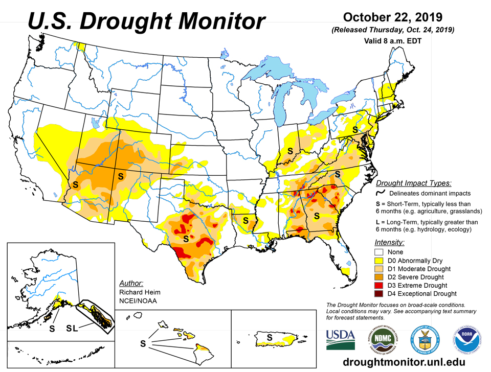
This U.S. Drought Monitor (USDM) week began with a low pressure and frontal system draped across the Gulf and East Coasts. Tropical Storm Nestor and its remnants moved across the Southeast then up the East Coast at mid-week. Another front moved across the South and approached the East Coast as the week ended. This combination of synoptic systems dropped several inches of rain across the drought areas of eastern Texas and from the Mississippi River to the East Coast. Meanwhile, several Pacific frontal systems brought precipitation to the Pacific Northwest while the Southwest to southern High Plains continued dry. Drought and abnormal dryness contracted across parts of the Pacific Northwest and southern Plains, and much of the Southeast, Ohio Valley, and Mid-Atlantic to Northeast. Drought and abnormal dryness expanded in the Southwest and parts of the southern and central Plains, as well as northeast Puerto Rico.
Northeast
Abnormal dryness contracted in New England. Drought and abnormal dryness were reduced in New Jersey to West Virginia.
Southeast
Heavy rain, locally over 5 inches, contracted drought and abnormal dryness across much of the region. Unfortunately, it was too late for some areas. Reports have been received through the Drought Impact Reporter of dry ponds and creeks, dead pasture, dying trees, and dying cattle in Gordon County, Georgia, as a result of the drought.
South
Drought and abnormal dryness expanded across parts of Texas and Oklahoma where precipitation deficits continued to mount. But other parts of Texas, and parts of Arkansas, Louisiana, Mississippi, and Tennessee experienced a reduction of drought and abnormal dryness.
Midwest
Abnormal dryness in Michigan was erased by precipitation this week, while large areas of 1 to over 2 inches of rain reduced abnormal dryness and drought in southern parts of the region.
High Plains
One to locally over 2 inches of precipitation fell across the Dakotas, but southern parts of the region were dry. Abnormal dryness and drought expanded in Colorado, Kansas, and Wyoming, and abnormal dryness established a toehold in southwestern Nebraska.
West
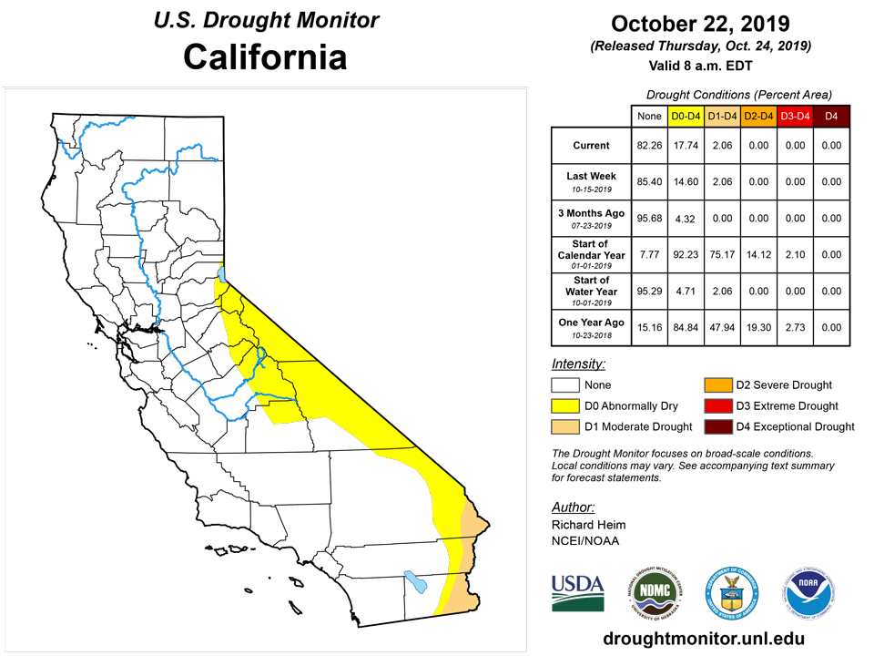
The abnormally dry (D0) areas of western Washington and Oregon received 2 to locally over 5 inches of precipitation this week, which was enough to end the D0 in those areas. But abnormal dryness and drought expanded from New Mexico to Nevada, with D0 inching a little further into eastern California. In southwest Utah, St. George (as of October 17) reported 122 days without measurable precipitation. As noted by the National Weather Service, this breaks the previous record of 121 days set in 1930. The Colorado Climate Center notes that this is only the fourth time since the site started reporting data in the late 19th century that the streak of consecutive rain-free days has topped 100, and not since the 1970s has that happened—until now. The last time St. George reported measurable precipitation was June 17, 2019.
Alaska, Hawaii, and Puerto Rico
In Puerto Rico, low streams and below-normal precipitation for the last 7 days to 6 months resulted in the introduction of D0 in the northeastern part of the island. Meanwhile, a strip of D0-D1 continued along the southwest to south central coast. There was no change to the depiction in Alaska or Hawaii.
Pacific Islands
Several weak surface troughs influenced the USAPI domain north and south of the equator during the first half of the USDM drought week (10/16/19-10/22/19). Very warm sea surface temperatures and low wind shear over the USAPI domain led to the development of Typhoon Bualoi, which passed just north of Saipan late in the week as a Category-3-equivalent typhoon on the Saffir-Simpson Wind Scale. Nearly two weeks earlier, Supertyphoon Hagibis followed a similar track, also passing just north of Saipan. Despite both Bualoi and Hagibis being very strong, Hagibis was a much larger typhoon, and thus, was much windier and wetter for the Mariana Islands. These typhoons to the north of the region were dominating the low level circulation pattern with trade winds feeding into them from the east and (weak) monsoon winds were feeding in from the west. After a mostly wet week across American Samoa this week, weak high pressure and somewhat drier conditions moved into the region by week’s end.
Satellite-based estimates of 7-day precipitation (QPE) showed heavy rainfall amounts ranging from 2-6 inches (locally greater) from near Kwajalein in the northern Republic of the Marshall Islands (RMI) west-northwestward across the northern Federated States of Micronesia (FSM) and the Commonwealth of the Northern Mariana Islands (CNMI) from Saipan northward. Much of this rain accompanied the track of Typhoon Bualoi, which grazed Saipan as a Category-3-equivalent typhoon, before intensifying even further after departing the Marianas. In contrast, the western FSM received little rainfall this past week.
The International Airport in Palau reported 0.88-inch of rain (1-day missing) during the past drought week (Oct 16-22), which falls well short of the 2-inch weekly minimum needed to fulfill most water requirements in this area. According to the NWS Forecast Office in Palau, Koror’s year-to-date rainfall total stands at 96.32 inches, and the normal for this period is 120.19 inches. This places Koror’s rainfall total to date at 80.1 percent of normal.
In the western Federated States of Micronesia (FSM), Yap reported only 0.19-inch of rain this week, with 3 days missing. Last week’s rainfall accumulation was nearly double the 2-inch weekly minimum, which helps to offset the more recent dryness. Woleai did not report this week, so no analysis was rendered for this station. In the central portion of Micronesia, Chuuk Lagoon reported 0.53-inch (1 day missing), and Lukunor reported only 0.17-inch (1 day missing). During the past 12 weeks (dating back to August 6th), Lukunor has had 6 weeks where less than 1-inch of rain was received (half the weekly minimum threshold). However, during the past 12 months, 6 of those months had rainfall totals that exceeded the 8-inch minimum threshold, and all but one of the remaining months had greater than 4 inches of rain (May, 3.75 inches). This indicates that in terms of receiving adequate rainfall, Lukunor is struggling primarily in the shorter-term. Nukuoro and Kapingamarangi fared much better, receiving 3.76 and 3.51 inches of rain this week, respectively. This marks the second consecutive week in which Nukuoro received over 3.5 inches of rain. If this wet trend continues, the station’s D0 drought class will likely be removed. For the three stations in eastern Micronesia (FSM), the weekly rainfall totals were: Pohnpei (1.30 inches), Pingelap (1.00-inch), and Kosrae (3.32 inches), respectively. No changes were deemed necessary to the drought-free status of these stations this week, especially Pohnpei which received over a foot of rain (12.14 inches) last week.
The Northern Marianas (CNMI) and Guam have seen two powerful typhoons graze the island chain during the past two weeks, with the eyes of both typhoons passing just north of Saipan, over or very close to the uninhabited island of Anatahan. There are various rainfall observing sites currently reporting for Saipan: a manned gauge (1.86 inches this week, 2 days missing), airport ASOS (5.76 inches), and the NPS (2.61 inches, 1 day missing). The NPS climate station at the American Memorial Park in Garapan, Saipan has received 13.88 inches of rain so far this month, with 3.08 inches falling on October 22nd associated with the passing of Typhoon Bualoi. Rota reported 2.53 inches of rain this week, and Guam reported 1.29 inches. All of these rainfall observations exceeded the 1-inch per week minimum threshold to meet water needs.
The Republic of the Marshall Islands (RMI) also experienced a wet week. Rainfall amounts included Kwajalein (2.24 inches), Wotje (2.28 inches, 1 day missing), Mili (2.44 inches, 1 day missing), Jaluit (2.85 inches, 1 day missing), Ailinglapalap (2.95 inches, 1 day missing), and Majuro (4.54 inches). Reservoir storage in Majuro rose from 27.3 million gallons at the start of the drought week to 30.4 million gallons by the end of the week, which represents an increase of 11.1 percent. The maximum capacity of this reservoir is 36 million gallons. One station, Utirik, received inadequate rainfall during the most recent drought week (0.95-inch, 1 day missing). No changes were made to the drought designations this week in the RMI.
South of the equator in American Samoa, both Pago Pago and Siufaga Ridge (National Park Service) reported well over an inch of rain for the week, the newly-established minimum threshold for meeting water needs. Pago Pago reported 4.63 inches of rain (1 day missing) and Siufaga Ridge reported 2.86 inches (1 day missing). Toa Ridge (also NPS) is currently down for maintenance. Given the above rainfall totals, there was no reason to revise the current drought-free status of Tutuila.
Virgin Islands
According to the NWS Forecast Office in San Juan, Puerto Rico, the Cyril E. King Airport in St. Thomas reported 1.71 inches of rain this week and 2.30 inches since October 1st. Observed rainfall totals of 5.81 inches and 28.74 inches were reported at the King Airport since September 1st and January 1st, respectively. These values are 62.2 and 97.5 percent of normal, respectively. Data from the CoCoRaHS station at Anna’s Retreat (VI-ST-1) indicated 5.46 inches during the week, and 8.13 inches since the beginning of September. The Grade School-3 Well level fell slightly during the USDM week, from 6.50 to 6.90 feet below the land surface. For Charlotte Amalie, SPI values at 1(-0.16), 3(+0.81), 6(+0.08), 9(+0.04), and 12(-0.25) months continue to support drought-free conditions.
The Henry E. Rohlsen Airport in St. Croix reported 0.95-inch of rain this past week, and 0.97-inch so far in October. Observed rainfall amounts since September 1st and January 1st are 2.85 inches (34.0 percent of normal) and 19.33 inches (67.8 percent of normal), respectively. The CoCoRaHS station at Christiansted (VI-SC-8) indicated 0.50 inches of rain this past week, and a total of 6.86 inches since September 1st. Groundwater levels at the Adventure 28 well continued to be low this week (20.3 feet below the land surface), following a general decline that began in late 2018. For Christiansted, SPI values at 1(-0.82), 3(-0.38), 6(-0.13), 9(-0.82), and 12(-1.24) months continue to support D0(S) conditions.
According to data provided by a volunteer observer, Windswept Beach on St. John received 1.12 inches of rain this past USDM week. This raises the year-to-date total accumulation to 29.64 inches. The Susannaberg DPW 3 Well level rose from 11.90 to 11.50 feet below the land surface. SPI values at 1(+0.26), 3(+0.47), 6(+0.37), 9(-0.14), and 12(-0.75) months support drought-free conditions.
Looking Ahead
For October 24-29, another low pressure/frontal system will spread heavy precipitation across eastern Texas and Oklahoma, and the Lower Mississippi Valley to southern New England, with 2 or more inches expected across much of this area. Half an inch to 2 inches can be expected from this band to the East Coast, except parts of northern Florida to coastal South Carolina which likely will receive less than half an inch of rain. Up to an inch of precipitation is forecast along the Rocky Mountain Chain and in parts of the Washington coastal range. Otherwise, little to no precipitation is in the forecast for the rest of the West, the central to northern Plains, and western Great Lakes. Below-normal temperatures are predicted for the central contiguous U.S. (CONUS) and warmer-than-normal temperatures for the East and West coasts. For October 29-November 2, a huge trough in the upper atmosphere will continue to funnel cold air into the central part of the country, resulting in below-normal temperatures for most of the CONUS. Odds favor above-normal temperatures only along the East Coast and parts of northern California, as well as all of Alaska. Above-normal precipitation is favored across most of Alaska and across the CONUS mostly east of the Mississippi River, while below-normal precipitation is expected from the Rockies to the West Coast as well as the southern High Plains.
Author(s):
Richard Heim, NOAA/NCEI
Anthony Artusa, NOAA/NWS/NCEP/CPC
Dryness Categories
D0 Abnormally Dry—used for areas showing dryness but not yet in drought, or for areas recovering from drought.
Drought Intensity Categories
D1 Moderate Drought
D2 Severe Drought
D3 Extreme Drought
D4 Exceptional Drought
Drought or Dryness Types
S Short-Term, typically less than 6 months (e.g. agricultural, grasslands)
L Long-Term, typically greater than 6 months (e.g. hydrologic, ecologic)
Source: National Drought Mitigation Center

