


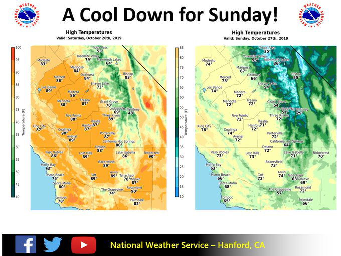
Mariposa projected high temperature for Saturday: 84 degrees, Sunday: 67 degrees
Oakhurst projected high temperature for Saturday: 84 degrees, Sunday: 66 degrees
Yosemite Valley projected high temperature for Saturday: 79 degrees, Sunday: 56 degrees
October 26, 2019 - The National Weather Service Hanford Office says what a difference a day can make.
We'll have one more day of summer-like temperatures across the southern San Joaquin Valley before we return back to fall on Sunday.
Temps will drop as much as 15 degrees with the passage of the next cold front.
  Area Forecast Discussion
  National Weather Service Hanford CA
  314 AM PDT Sat Oct 26 2019


  .SYNOPSIS...
  High temperatures this afternoon will be around ten degrees above
  normal for this time of year. A cold front will pass through
  Central California Sunday, bringing with it much cooler weather
  and gusty winds. Seasonal afternoon temperatures and chilly
  overnight temperatures are expected Monday through Wednesday. Dry
  weather will persist through at least Friday.

  &&

  .DISCUSSION...
  A cold front will move southward through the Pacific Northwest
  today and tonight. Prevailing winds will transport smoke from
  wildfires in Sonoma County southeastward over Central California
  today and tonight. Maximum temperatures this afternoon will be
  around ten degrees above normal for this time of year. The
  aforementioned cold front will progress southward through Central
  California Sunday. High temperatures Sunday afternoon will be
  around fifteen degrees cooler than this afternoon. Gusty winds
  will produce blowing dust in the San Joaquin Valley and Kern
  County desert, mainly Sunday afternoon. A Wind Advisory will
  likely be required for the West Side Hills and western portion of
  the San Joaquin Valley Sunday.

  After passing through Central California, the cold front will move
  in more of an eastward direction through the Desert Southwest
  Sunday night and Monday. Another cold front will progress
  southward through the Pacific Northwest Monday night and Tuesday.
  This cold front should pass through Central California Tuesday
  night or Wednesday. High temperatures Monday through Wednesday
  will be near or slightly below normal for the latter half of
  October. Overnight minimum temperatures will be chilly. Patchy
  frost is possible in the San Joaquin Valley during the early
  morning hours of Monday through Wednesday. Widespread frost is
  conceivable in the Kern County desert during the early morning
  hours of Monday through Wednesday.

  An Eastern Pacific area of high pressure, west of the Pacific
  Northwest, will build southeastward Wednesday night through at
  least Friday. This will result in a warming trend Thursday into
  next weekend. Dry weather will persist throughout Central
  California into the foreseeable future.
Source: NWS

