


California and National Drought Summary for October 29, 2019
Summary
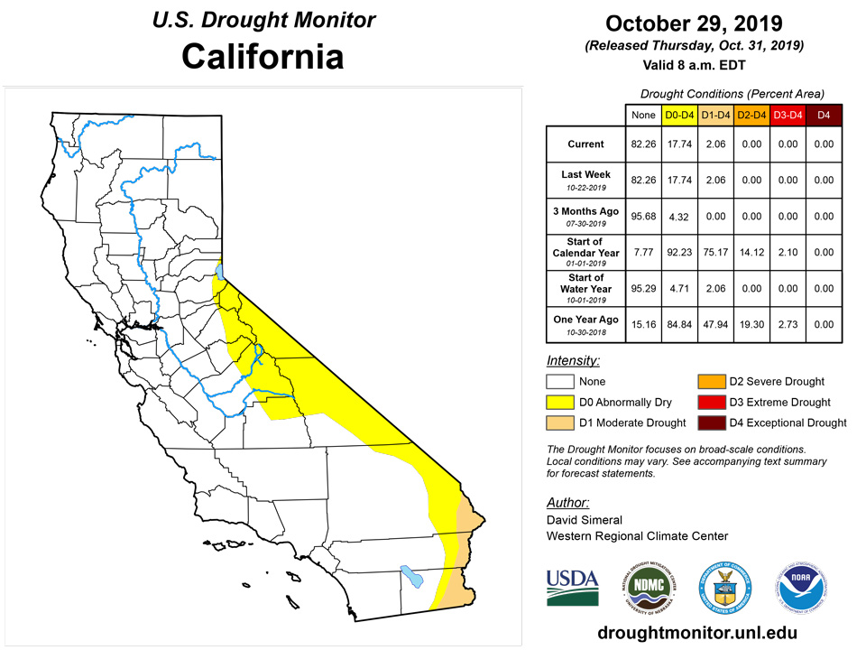
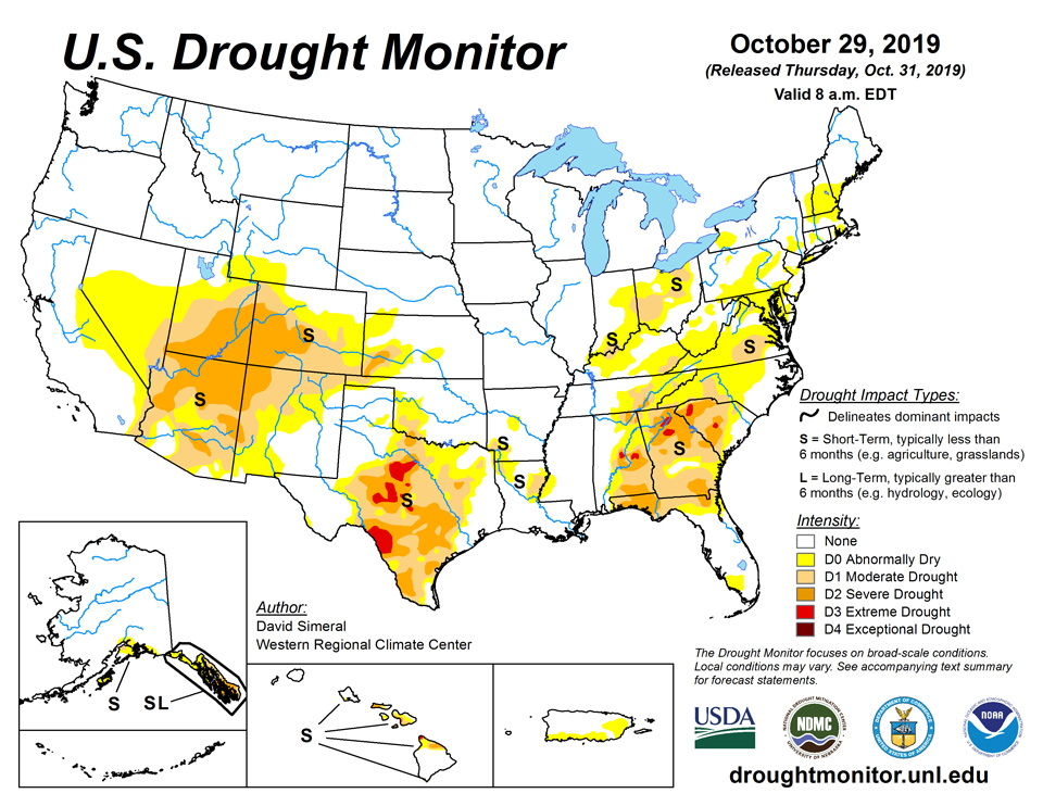
October 31, 2019 - This U.S. Drought Monitor week saw widespread improvements in drought-stricken areas across portions of the South, Southeast, and Mid-Atlantic, as moderate-to-heavy rainfall accumulations were observed associated with storm systems fueled by residual moisture from Tropical Storm Olga. Across these areas, precipitation accumulations ranged from 2-to-10 inches leading to improvements on the map in Louisiana, Mississippi, Tennessee, Alabama, Georgia, South Carolina, North Carolina, and Virginia. In California, numerous wildfires are burning across northern and southern portions of the state, including the Kincaide Fire (the state’s largest active fire) in Sonoma County that has burned approximately 76,000 acres. In southern California, firefighting efforts have been hampered by strong Santa Ana winds that are causing extreme fire behavior.
Northeast
On this week’s map, one-category improvements were made in areas of Abnormally Dry (D0) and Moderate Drought (D1) in Connecticut, Delaware, Maryland, New York, Pennsylvania, and West Virginia. These improvements were in response to widespread light-to-moderate rainfall accumulations (7-day) ranging from 1-to-3+ inches with the heaviest accumulations observed in central Pennsylvania. For the past 30-day period, percentage of normal precipitation has been above normal across most of the region with the exception of a few drier pockets in southern Vermont, northeastern Maine, and southern Delaware. Average temperatures for the week were 2-to-6 degrees above normal across the region with the greatest positive anomalies observed in northeastern Pennsylvania.
Southeast
The region received beneficial rains during the past week with the heaviest precipitation (2-to-8 inches) falling across northern and western Alabama, northwestern Georgia, western North Carolina, western Virginia, and central Maryland. In response, one-category improvements were made in areas of Extreme Drought (D3), Severe Drought (D2), and Moderate Drought (D1). According to the USDA for the week ending October 27th, the percent of subsoil by state rated short to very short was as follows: Virginia 45%, North Carolina 28%, South Carolina 57%, Georgia 66%, Florida 28%, and Alabama 51%. Across the region, average temperatures were 2-to-6 degrees above normal for the week.
South
Widespread showers and thunderstorms were observed during the past week in the Deep South in association with post-tropical cyclone Olga, which made landfall Saturday along the central Louisiana coast. Across the region, rainfall accumulations ranged from 2-to-10 inches across Louisiana and Mississippi—leading to one-category improvements in areas of Severe Drought (D2), Moderate Drought (D1), and Abnormally Dry (D0). Likewise, improvements were made across eastern Tennessee in areas of Extreme Drought (D3), Severe Drought (D2), and Moderate Drought (D1) where rainfall accumulations ranged from 1-to-3 inches. In Texas, bands of heavy rainfall (2-to-4 inch accumulations) were observed in the Hill Country, Gulf Coast, and North Texas leading to one-category improvements; areas in the western part of the state were generally dry leading to expansion of areas of Moderate Drought (D1) and Abnormally Dry (D0). According to the USDA for the week ending October 27, the percent of subsoil by state rated short to very short was as follows: Mississippi 12%, Arkansas 16%, Louisiana 3%, Tennessee 39%, Oklahoma 38%, and Texas 55%. Average temperatures were mainly below normal across the region with the greatest negative anomalies observed across the Oklahoma and Texas Panhandles where temperatures were 10-to-15 degrees below normal.
Midwest
On this week’s map, one-category improvements were made in areas of Severe Drought (D2) and Moderate Drought (D1) in Indiana and Kentucky in response to precipitation accumulations ranging from 1-to-3 inches. According to the USGS, streamflows are running at normal to well above normal levels across nearly the entire region. According to the USDA for the week ending October 27th, the percent of subsoil by state rated short to very short was as follows: Minnesota 1%, Iowa 2%, Missouri 3%, Wisconsin 0%, Illinois 12%, Michigan 4%, Indiana 39%, Ohio 43%, and Kentucky 49%. For the week, average temperatures were mainly near normal to slightly above normal across much of Indiana, Kentucky, and Ohio, while further west in the region temperatures were 4-to-8 degrees below normal.
High Plains
On this week’s map, no changes were made across the region. According to the October 25th North American Land Data Assimilation System (NLDAS), the current total column soil moisture percentiles were at 70% or greater across North and South Dakota while some dry soil pockets were present in eastern Colorado. Average temperatures for the week were 3-to-15+ degrees below normal with the greatest negative anomalies observed in the plains of Colorado and Wyoming.
West
Across most of the region, dry conditions prevailed with the exception of some snowfall activity in the central and northern Rockies, as well as in the Uinta and Wasatch ranges of Utah. According to the NRCS SNOTEL network, snow water equivalent (SWE) levels are above normal across all of the major drainage basins in the northern half of the region. In California, numerous wildfires are burning across the state including the Kincade Fire near the northern California community of Geyserville where approximately 76,000 acres have burned, according to the October 30th National Interagency Coordination Center’s Incident Management Situation Report. In southern California, low humidity and strong Santa Ana winds have led to extreme fire weather conditions that have exacerbated fire-fighting efforts in the greater Los Angeles area. During the past week, average temperatures were below normal across most of the region with the exception of California where temperatures were 3-to-9 degrees above normal. Further inland, well-below normal temperatures were observed across the eastern Great Basin and Intermountain West with average temperatures ranging from 6-to-15 degrees below normal.
Alaska, Hawaii, and Puerto Rico
No changes were made on this week’s map in the Hawaiian Islands. Average temperatures for the week were slightly above normal (1-to-4 degrees) across the island chain with the exception of the southwestern portions of the Big Island where temperatures were a few degrees below normal. During the past week, dry conditions prevailed across the islands except for some light-to-moderate shower activity (1-to-2.5 inches) on the windward side of the Big Island as well as along the Kona Coast. In Alaska, minor improvements were made in an area of Moderate Drought (D1) on Kodiak Island as well as removal of areas of Abnormally Dry (D0) on the Kenai Peninsula and in the Interior extending southward into the Mat-Su Valley. This week, the Interior, much of western Alaska, and the North Slope saw light-to-moderate precipitation with liquid accumulations of generally less than 1 inch while heavier accumulations were observed on Kodiak Island, Prince William Sound, and portions of Southeast Alaska. Average temperatures for the week were above normal across much of Alaska—including the Interior and Southwest regions that experienced temperatures 10-to-12 degrees above normal. In Puerto Rico, improvements in conditions in the short-term led to removal of an area of Moderate Drought (D1) along the southern coast.
Pacific Islands
A variety of features characterized the weather pattern over Micronesia during this USDM week (10/23/19-10/29/19). They included surface troughs, surface convergence, and trade-wind convergence in many areas; weak circulations over Yap State and Palau; and trade-wind disturbances over the Marshall Islands (RMI) and east of the Marianas. Upper-level lows and troughs along the northern portions of Micronesia created divergence aloft which enhanced showers generated by the surface convergence. South of the equator, American Samoa was dominated by dry high pressure for most of the week, with a surface trough moving over the territory near the end of the week.
Satellite-based estimates of 7-day precipitation (QPE) showed areas of 2-4 inches of precipitation, and locally more, over the Republic of Palau and Yap State, with a patchy band of 1-3 inches across eastern parts of the Federated States of Micronesia (FSM) and the southern Marshall Islands (RMI). Less than an inch of rain was indicated outside these areas. The QPE depicted a band of 2 to more than 4 inches of rain south of the Samoan Islands, with 1-2 inches over American Samoa and less than an inch to the north.
Drought free conditions persisted across Palau during October 23-29 since it was an extremely wet week. Koror, Palau had a total of 7.46 inches of rain, which is close to the the 8-inches monthly threshold needed to meet most water needs. As of 29 October 2019, Palau’s October rainfall total was 11.65 inches.
Precipitation totals varied from 0.51 inch to 5.78 inches across the Marianas Islands. Guam had 1.40 inches and Rota had 0.51 inches of rain for the week. The highest precipitation total of 5.78 inches came from Saipan’s manual gauge, while two other observing stations in Saipan had 0.50 inch (ASOS) and 0.71 inch (NPS) of rain for the week. Given that the other two Saipan stations had much less precipitation, it is very likely that the amount of 5.78 inches was actually the sum of 9 days (from October 21-29). According to the data available from the manual gauge, 4.98 inches of rain was reported on October 23, with data from October 21-22 missing. While the rest of the week (October 24-29) had a total of 0.80 inch of rain, consistent with the precipitation totals reported by the other Saipan stations. Nonetheless, all three stations had an October 2019 rainfall total that was more than double the monthly minimum of 4 inches. For this reason, D-Nothing status continues across the Marianas.
Dry conditions affected the Federated States of Micronesia. Chuuk Lagoon had the least precipitation during October 23-29, 2019, receiving only 0.68 inch of rain (1 day of missing data). This week marked Chuuk Lagoon’s second consecutive week with little rain. However, since the October 2019 precipitation totals were above the 8-inches monthly threshold, D-Nothing remained this week for Chuuk. Woleai has been very dry, with 6 of the last 9 weeks receiving less than 1 inch of rain. Overall, the month of September and October have had less than 4 inches of rain, which is less than the 8-inches of rain needed to remain drought free. However, since there were 14 days and 12 days of missing data for the months of September and October, the drought classification of abnormally dry was not changed. If dry conditions persist next week, severe drought may be introduced. Lukunoch had 1.47 inches (2 days of missing data) of rain this week and the September (6.44 inches) and October (5.79 inches) monthly precipitation were below the 8 inches threshold to meet most water needs. However, since the monthly totals were more than half the monthly threshold, abnormally dry conditions were unchanged for this location. Yap, Pohnpei, Kosrae, and Pingelap had 1.40, 1.98, 1.40, and 1.40 inches of rain, respectively, which is less than their weekly minimum of 2 inches. However, since their monthly precipitation totals were close to or above their 8-inches monthly threshold to meet most water needs, drought free conditions persisted for these locations. Kapingamarangi and Nukuoro drought classifications changed this week from abnormally dry to drought free conditions. Although Nukuoro (1.37 inches) received less than 2-inches of rain this week, its October precipitation total surpassed the 8-inches threshold required to meet most water needs at 8.99 and 10.16 inches, respectively. Fananu and Ulithi were set to missing due to lack of data at the time of analysis.
Most of the Marshalls Islands had a dry week, receiving less than their 2-inches weekly precipitation threshold to meet most water needs. Ailinglapalap and Kwajalein had 1.84 and 1.64 inches this week, however, the monthly totals for October surpassed the 8-inches minimum. Majuro had 3.38 inches of rain, while Mili had 6.85 inches. All four stations remained in drought free status. Jaluit (0.33 inch) and Wotje had the least precipitation, with Wotje observing no precipitation during the week. Since this was the first dry week after two very wet weeks, Wotje remains in abnormally dry status, while Jaluit remains in severe drought. Meanwhile, Utirik’s drought classification was changed from drought free to abnormally dry since this week marked the third consecutive week with dry conditions and the month’s total was 5.89 inches so far.
Pago Pago had 2.86 inches of rain this week, surpassing the weekly threshold of 1-inch to meet most water needs. The station located in Siufaga Ridge was slightly wetter with a total of 3.61 inches of rain for the week. Pago Pago had a total of 5.28 inches for the month. As a result, drought free conditions remains in Tutuila.
Virgin Islands
Across St. Thomas, Cyril E. King Airport had 0.25 inch of rain this week, while the monthly rainfall total at the airport was 2.55 inches or 52.7% of normal October precipitation. However, the year-to-date rainfall total for the airport was 94.8% of normal. According to the CoCoRaHS station at Anna’s Retreat 2.5 ESE, the rainfall total for the week of October 23-29 was 0.9 inch of rain, while the month had 6.58 inches of rain. SPI values at 3, 6, 9, and 12 months indicated drought free conditions, while the 1 month SPI value indicated moderate drought with a value of -0.82. Groundwater levels at the Grade School-3 Well continued to slightly drop from 3.91 feet on September 10 (the smallest depth to water level below land surface in 2019) to 7.96 feet below land surface on October 29. For now, drought free conditions persist across St. Thomas.
Similarly, the Henry E. Rohlsen Airport in St. Croix received only 0.15 inch of rain this week, with only 1.12 inch of rain for the month (as of October 29) or 24.0% of normal precipitation for October. The year-to-date total of 19.48 inches is 65.7% of normal precipitation. Meanwhile, the Christiansted 1.8 ESE CoCoRaHS station had a weekly rainfall total of 0.45 inch and 1.03 inches for the month as a whole. The Adventure 28 Well had groundwater at 20.43 feet below land surface, the largest depth to groundwater level since April 2017. SPI values for St. Croix are consistent with moderate to severe drought at 1 (-1.54), 3 (-1.31), 6 (-0.87), 9 (-0.94), and 12 (-1.56) months. For this reason, drought classification was changed from abnormally dry to moderate drought in St. Croix.
St. John also received less than one inch of rain during October 23-29, with rainfall total at 0.27 inch, according to data provided by a volunteer observer. The October 2019 rain total of 3.97 inches was 66.8% of normal. The year-to-date rainfall was 31.77 inches, which is 85.4% of normal. SPI values at 1, 3, 6, and 9 months were wet or neutral, indicating drought free conditions, while the 12-month SPI value of -0.75 indicates abnormally dry conditions. The Susannaberg DPW 3 Well groundwater was at 11.55 feet below land surface, which is a slight increase from 16.16 feet below land surface on July 21, 2019 (the highest depth to groundwater level in 2019). For this week, St. John remains in drought free status.
Looking Ahead
The NWS WPC 7-Day Quantitative Precipitation Forecast (QPF) calls for moderate-to-heavy accumulations ranging from 2-to-5+ inches across portions of the South, Southeast, Mid-Atlantic, and Northeast. Lower accumulations (<2 inches) are expected across a swath extending from eastern Texas northward across most of the Plains states and Upper Midwest. Out West, liquid accumulations of generally less than 1 inch are expected across the Rockies and North Cascades of Washington state. The CPC 6–10-day Outlook calls for a high probability of above-normal temperatures across the Far West, Great Basin, and Southwest while areas east of the Rockies are expected to be below normal with the exception of Florida. In terms of precipitation, there is a high probability of below-normal precipitation across the Pacific Northwest, northern California, northern Great Basin, and the Intermountain West as well as in the central and southern Plains, lower Midwest, South, and Mid-Atlantic. Conversely, the northern Plains, Upper Midwest, southern Texas, and Florida are expected to have above-normal precipitation.
Author(s):
David Simeral, Western Regional Climate Center
Ahira Sanchez-Lugo, NOAA/NCEI
Dryness Categories
D0 Abnormally Dry—used for areas showing dryness but not yet in drought, or for areas recovering from drought.
Drought Intensity Categories
D1 Moderate Drought
D2 Severe Drought
D3 Extreme Drought
D4 Exceptional Drought
Drought or Dryness Types
S Short-Term, typically less than 6 months (e.g. agricultural, grasslands)
L Long-Term, typically greater than 6 months (e.g. hydrologic, ecologic)
Source: National Drought Mitigation Center

