


Temperatures Above Normal through early 2020.
Good Chance of a delayed start to the “rainy season” with a high likelihood of below normal rainfall this winter.
Near normal to slightly above number of offshore wind events expected through December.
Weather Discussion
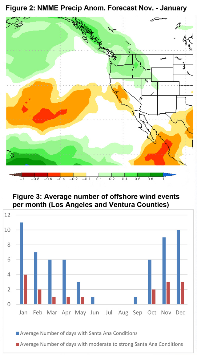
November 2, 2019 - After an 11-month hiatus, seasonal offshore winds made a dramatic return in October. Approximately 6 days of moderate to strong events occurred last month an additional 3-4 days of
 weaker winds (compare with normal in figure 3, below). The offshore winds of Oct. 10-11th as well as the strong event of October 30th stand out as they resulted large fires which raced through tinder-dry vegetation.
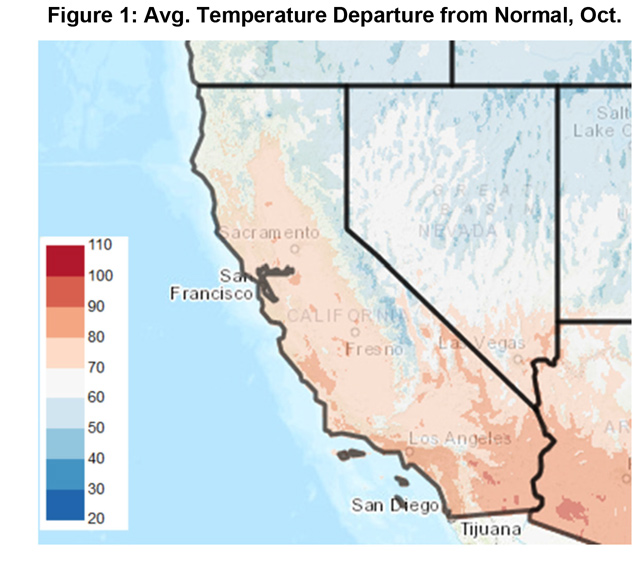
The higher than normal frequency of offshore winds days was the end result of a strong buckling of the long wave pattern across the CONUS. A highly amplified, stationary ridge formed in the Eastern Pacific which allowed deep troughing to form over the Rockies and Midwest. Periodic intrusions of cold air produced strong offshore pressure gradients during the event of October 30th in particular. Temperatures over the intermountain west were some 30- 40 degrees below normal during that period which led to some of the strongest offshore pressure gradients seen over Southern California in years.
Seemingly, the atmosphere flipped a switch at the end of September from one which produced progressive, jetdriven storms system to one of light winds aloft and a persistently dry airmass. Some of the reasons for this wholesale change in atmospheric circulation may be that the atmosphere finally synched with current sea surface temperatures (SST) across the Pacific.
SST’s over the Eastern Pacific have remained well above average from the Gulf of Alaska southward to the equator the past few months. Despite this, an active jet had been bringing storms into the Pacific Northwest on a 3-4 day cycle, resulting in wetting rains over Northern CA and cool, onshore flow over the southern part of the state. But now that the ridge has been parked over the Eastern Pacific in close alignment with the area of greatest positively anomalous SST’s, it may be some time before this pattern breaks down. There has been a tendency the past few years for these Eastern Pacific ridges to “lock in” with warm SST’s in a pattern which favors prolonged periods of warmer and drier than normal weather.
Warmer than normal SST have also migrated westward along the equator while cooler SST blossomed of the west coast of South America. This may be the beginnings of a Modoki ENSO pattern, which often brings drier than normal weather to the West Coast during the winter months.
Long term models may have picked up on these trends as most members of the North American Multi-Model Ensemble (Figure 2, below) are predicting below normal precipitation for much of the state through early next year. Other long-range models such as the JAMSTEC offer similarly dry predictions the rest of the fall and into the winter.
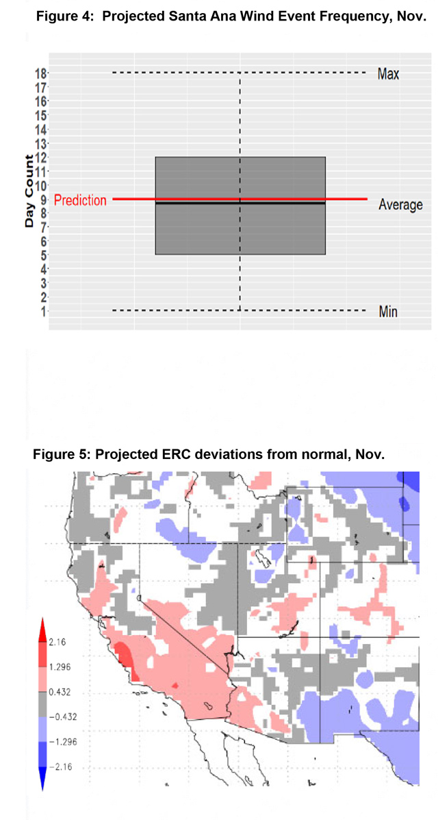
Local forecast guidance continues to project an average to slightly above number of offshore wind days for the next 30 days. The presence of a possible emerging Modoki ENSO pattern may acerbate this forecast and a slightly higher than average forecast may begin to skew toward a significantly higher than average forecast if current long wave patterns continue into December.
FUELS AND DROUGHT OUTLOOK
The anticipated weather offers little in the way of good news this fall. In a similar vein, the fuel moisture levels in both live and dead vegetation is decidedly bleak. Dead fuel moisture took a steep drop in small fine fuels as well as large diameter, heavier fuels in late Sept – October due to the warm dry weather. The offshore winds over Southern CA, unsurprisingly, pushed dead fuel moisture toward the 90-95th percentile in terms of dryness. Live fuels are now close or at critically dry levels. There isn’t much variance across the district as there was little summertime monsoonal rainfall this past season. In short, fuels across the district are uniformly very dry.
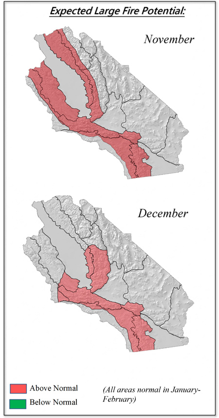
A weather pattern which favors offshore winds occurring over fuel beds that are primed for burning will lead to above to well above normal large fire potential through November. Southern CA may not see any lowering of large fire potential until late December. Offshore winds may lead to periods of critically high fire potential over Southern California the next few weeks.
Fires that start at lower elevations of the Sierra Foothills may find little resistance to growth at higher elevations above 7,000 feet. Only the fact that we are now well into fall with its short daylight hours and low solar angle may help quell fire behavior during non-windy periods. Of course, windy weather will allow for rapid rates of spread and aggressive fire behavior due to severely dry fuels. Windy weather at night may allow for fires to burn actively through several burn periods which is not the norm this time of year.
Resource demand may be heavy well into December. Drier than normal weather is also quite likely across the Southwest and Southern Great Basin and there may be some competition for out of region resources.
This may be a long fall and winter across California for both the fire-fighting community and the general public in terms of coping with the threat of fires. The best thing citizens can do is to be fire wise. Now is the time to prepare for wildfires and to have a plan to be ready for wildfires if they arrive in your area.
Source: Predictive Services

