


California and National Drought Summary for November 12, 2019
Summary
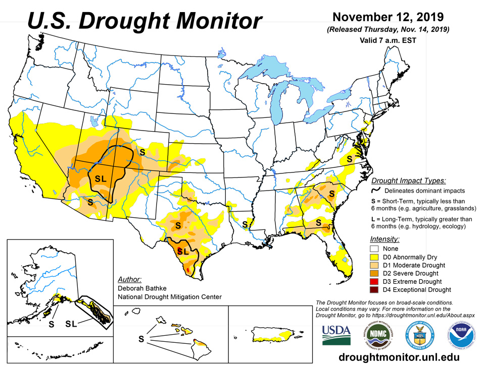
November 14, 2019 - Much of the eastern half of the country saw widespread snow and rain combined with record-breaking cold during the Drought Monitor week ending Tuesday, November 12. The combination helped alleviate short-term dryness and drought in much of Texas, the Ohio River Valley, the Mid-Atlantic, and Southeast. Meanwhile, the dry pattern continued across California and the Great Basin, leading to a deterioration in conditions. Six weeks into the water year, many parts of the country have yet to see any precipitation, while higher than normal temperatures have kept evaporative demand high.
Northeast
Improvements continued this week in the Northeast with the removal of pockets of abnormal dryness (D0) from southeast New York, Pennsylvania, Delaware, and West Virginia. Recent rainfall combined with low temperatures have improved precipitation deficits, soil moisture, and streamflow.
Southeast
The trend toward improvements continued this week in the Southeast in response to another round of beneficial rain and below-normal temperatures. The combination helped to lessen rainfall deficits, replenish soil moisture, and increase streamflow. In response, one-category improvements were made in areas of severe drought (D2), moderate drought (D1), and abnormal dryness (D0) in South Carolina, Georgia, and Alabama. While the Florida Panhandle benefited from the rain and saw improvements, south and central Florida did not. Continued above-normal temperatures and rainfall shortages (3 to 10 inches over the last 90 days) led to the introduction of abnormal dryness (D0).
Midwest
Another week of cool weather combined with snow and rain helped alleviate dryness and drought across the region. Ohio and Indiana saw the removal of the remaining pockets of abnormal dryness (D0). Improvements in Kentucky included the elimination of moderate drought. Reports from the state coordination team indicate recovery to streamflow and soil moisture and the removal of the state’s drought declarations.
High Plains
Weather this week in the High Plains was marked by temperature swings ranging from 4 to 16 degrees above normal on Saturday, November 9th to 11 to 29 degrees below normal on Tuesday, November 11th. Most of the region less than 0.5 inches of precipitation. The only changes to this week’s map were in Kansas and Colorado. In Kansas, the west-central region saw the expansion of abnormal dryness (D0) and the southwest saw small degradations in moderate (D1) and severe (D2) drought as precipitation deficits continue to build. Colorado saw a one-category improvement in the north-central part of the state based on feedback from the state coordination group and the cold, snowy start to the winter. SNOTEL sites in the region indicate that the water year is starting off with snow water equivalent values ranging from near to more than 200 percent of normal.
South
Widespread rain and cooler than normal temperatures across the region led to one-category improvements in southeast Tennessee, west-central Oklahoma, and much of Texas. Improvements in Tennessee are supported by precipitation, streamflow, and soil moisture. In Oklahoma, the northern edge of abnormal dryness was trimmed as precipitation deficits in this area have been erased out to six months. Many of the drought-affected areas in Texas saw weekly precipitation that exceeded 300 to 600 percent of normal, resulting in the elimination of extreme drought (D3) in the northern part of the state and overall reductions to the other categories. The southern part of the state also saw broad areas of improvement. Note that the designation “SL” was added to the southwest region to reflect the short- and long-term nature of the precipitation deficits and impacts.
West
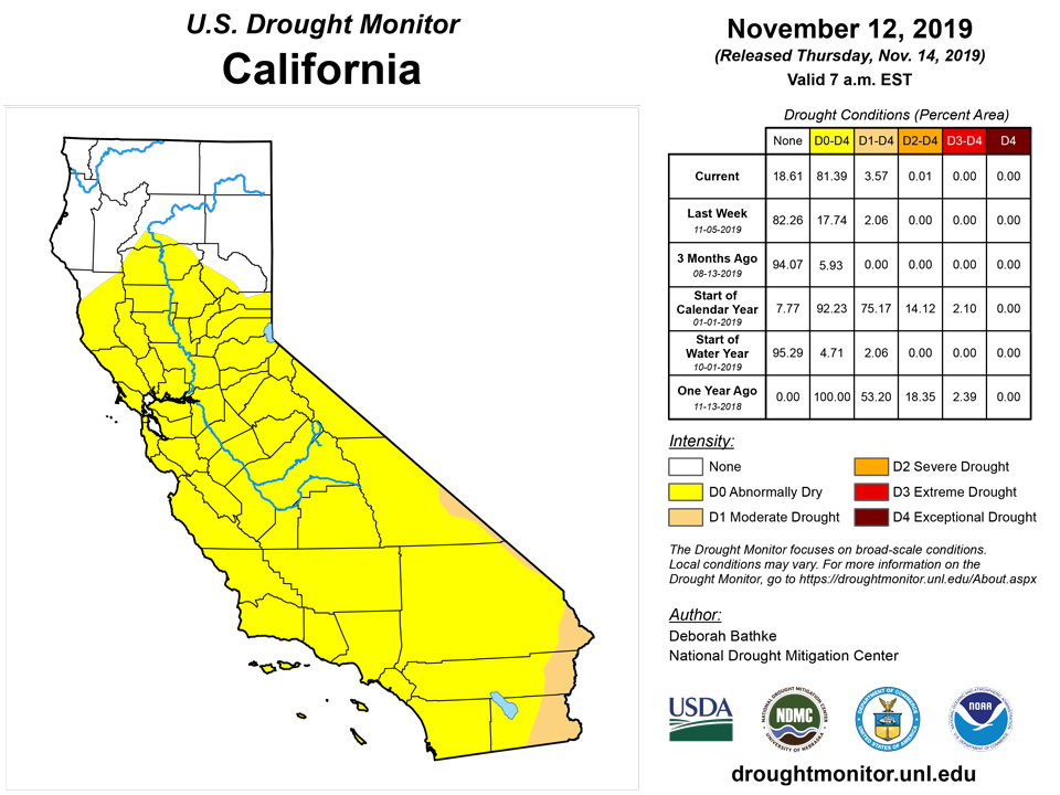
Analysis and discussions regarding the map’s depiction in the West focused on the effects of above-normal temperatures combined with a dry monsoon season in Arizona and New Mexico and a lack of precipitation to start the water year in parts of California, Nevada, and Utah. Coordination with state monitoring groups led to the expansion of D0 across the southern two-thirds of California and central Nevada; expansion of moderate drought (D1) in southern California, southern Nevada, and Utah; and severe drought (D2) in southern Nevada, Utah, and northwest Arizona. While reservoirs remain high, numerous indicators support dryness, including 60-day precipitation deficits, high evaporative demand, and vegetation health. In New Mexico, abnormal dryness (D0) and moderate drought (D1) expanded to the southeast.
Alaska, Hawaii, and Puerto Rico
No changes were made to the map in Alaska, Hawaii, or Puerto Rico this week. Reports from local experts in Hawaii and Puerto Rico noted that conditions remain aligned with last week’s status. In Alaska, below-normal precipitation in the south-central part of the state and northern Panhandle weren’t enough to erase longer-term deficits.
Pacific Islands
The weather pattern over Micronesia during this USDM week (11/06/19-11/12/19) consisted of several weak circulations, surface troughs, and tropical disturbances. A monsoon trough set up across western Micronesia and stretched eastward across the region by week's end. By the end of the week, a circulation near Kwajalein intensified into Tropical Depression 26W (then later, as it moved west, into Tropical Storm Fengshen) while a circulation near Koror developed into Tropical Depression 27W. South of the equator, a surface trough swept across the Samoan Islands during the week, but high pressure tended to dominate. Satellite-based estimates of 7-day precipitation (QPE) showed areas of 2+ inches of precipitation across parts of the Federated States of Micronesia (FSM) and Marshall Islands (RMI), with areas of less than an inch across other parts of Micronesia. Less than half an inch of rain was indicated on the QPE for much of the Samoan region, with half an inch to an inch over parts of American Samoa.
The past week in American Samoa was relatively dry, with rainfall totals of 1.22, 0.40, and 0.50 inches (with one missing day) at Pago Pago, Siufaga Ridge, and Toa Ridge, respectively. However, periods before this week have been wet enough to preclude abnormal dryness from developing.
4.94 inches of rain fell in Palau this week, bringing the November total to 9.39”. Palau remained free of drought or abnormal dryness.
A drier week took place on Saipan, with rainfall measurements ranging from 0.76 to 1.22 inches. However, given large rainfall amounts in September and October, abnormal dryness has not developed there yet. In the last two weeks, Rota received 1.07 and 1.88 inches of rain, so drought-free conditions continued there. In Guam, 2.67 inches of rain fell this week, so drought-free conditions also continued there.
Conditions on Yap were drier this week with only 0.41 inches of rain reported, though two days of data were missing. However, October precipitation reached 8.22 inches and rainfall last week reached 3.17 inches, which is keeping conditions from becoming abnormally dry. No data was reported for Ulithi or Fananu, so no Drought Monitor depictions are being made in either place this week. Short-term abnormal dryness continued at Woleai; however, 3.98 inches of rain fell there this week, so conditions have improved some. At Chuuk, rainfall this week totaled 1.33 inches, while last week’s rainfall totaled 3.23 inches. Given the context of a very dry last two weeks of October, some short-term dryness is beginning to occur there, but it is not yet at the level of abnormal dryness. At Lukunor, 1.44 inches of rain fell this week (with one day of missing data), and abnormally dry short-term conditions continued there. Only 0.82 inches of rain fell in Nukuoro this week, but given that last week’s rainfall exceeded 2 inches and October rainfall exceeded 10 inches, short-term conditions are not yet abnormally dry. In Kapingamarangi this week, 1.78 inches of rain fell, but given that the previous three weeks exceeded 2 inches and October rainfall was 10.22 inches, drought-free conditions continued there. Last week in Pohnpei, 12.86 inches of rain fell, and 4.63 inches fell this week, bringing November totals to 17.04 inches, more than double their normal monthly total for November. No data were available for Pingelap this week, so no drought depiction was made there. In Kosrae, 4.39 inches of rain fell this week, and drought-free conditions continued.
In Kwajalein, 2.05 inches of rain fell this week, and drought-free conditions continued there. At Ailinglaplap, 1.28 inches of rain fell this week, but 5.54 inches fell last week, so drought-free conditions continued here. Short- and long-term severe drought continued at Jaluit this week, though 2.30 inches of rain fell this week, so the short-term has become a little wetter. At Utirik, 2.34 inches of rain fell this week, so drought-free conditions continued. In Wotje, 3.41 inches of rain fell this week, and drought-free conditions continued. Majuro received 2.66 inches of rain this week, and drought-free conditions continued. 4.13 inches of rain fell in Mili this week, and drought-free conditions continued.
Virgin Islands
Drought-free conditions continued this week on both St. Thomas and St. John, though some dryness exists at 9- and 12-month time scales at St. John. Short- and long-term moderate drought continued this week at St. Croix.
Looking Ahead
Over the next week, generally warmer than normal temperatures are expected in the western U.S. Farther east, the cold, polar air mass responsible for the early week chill in the central and eastern U.S. will exit to the east, leaving more moderate temperatures in its wake. Some rain is forecast by the National Weather Service Weather Prediction Center in east Texas on Thursday, with rain also occurring in the Southeast through Monday. Elsewhere, some precipitation is also expected in the Pacific Northwest, and generally dry conditions are forecast elsewhere.
Author(s):
Deborah Bathke, National Drought Mitigation Center
Curtis Riganti, National Drought Mitigation Center
Dryness Categories
D0 Abnormally Dry—used for areas showing dryness but not yet in drought, or for areas recovering from drought.
Drought Intensity Categories
D1 Moderate Drought
D2 Severe Drought
D3 Extreme Drought
D4 Exceptional Drought
Drought or Dryness Types
S Short-Term, typically less than 6 months (e.g. agricultural, grasslands)
L Long-Term, typically greater than 6 months (e.g. hydrologic, ecologic)
Source: National Drought Mitigation Center

