


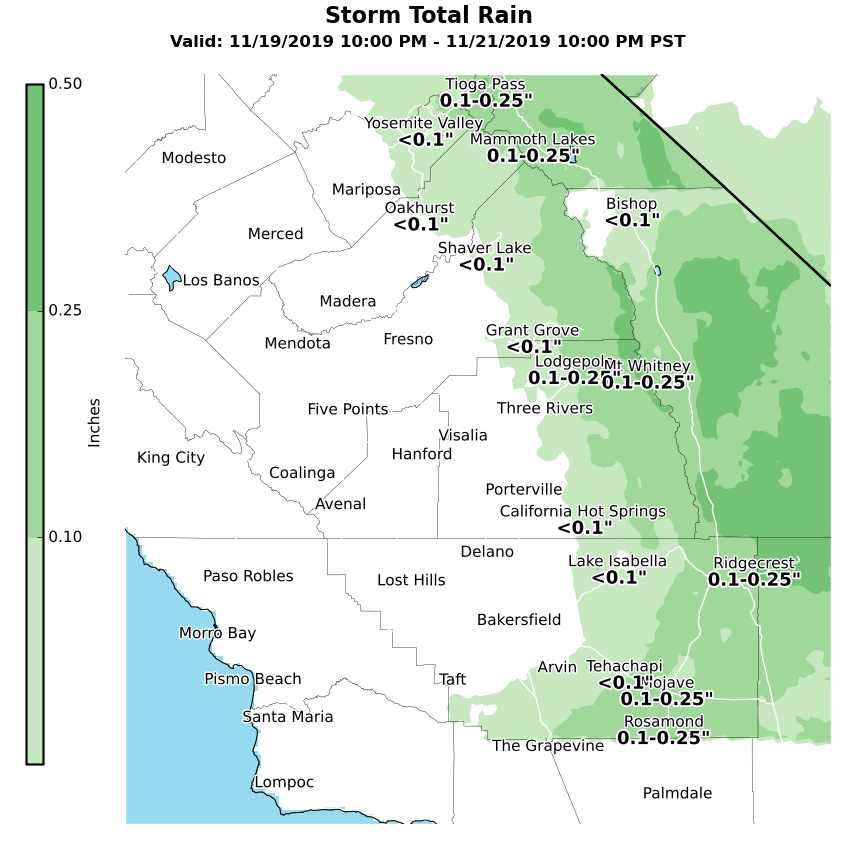
No rain expected for Mariposa
Less than 0.10" of rain for Oakhurst
Less than 0.10" of rain for Yosemite Valley
November 16, 2019 - The National Weather Service Hanford Office says now that wet weather has become more of a possibility across parts of central CA. next wk, we've put together a preliminary map of expected rainfall from Wed into Thu eve.
Up to a few inches of snow could fall over the Sierra above 7000 feet.
  Area Forecast Discussion
  National Weather Service Hanford CA
  400 AM PST Sat Nov 16 2019


  .SYNOPSIS...
  Dry weather will continue over the district through at least next
  Tuesday. A warming trend during the next few days will bring high
  temperatures to well above normal by Monday. A cooling trend will
  follow for the remainder of next week with the possibility of wet
  weather Wednesday and Thursday, mainly over mountains and desert.

  &&

  .DISCUSSION...
  Satellite imagery continues to show low clouds over the south end
  of the San Joaquin Valley and adjacent slopes. Expect these clouds
  to linger into the early morning hours then dissipate with daytime
  heating and a drier easterly flow. An upper ridge of high pressure
  over the eastern Pacific will begin to build inland today for some
  slight warming over yesterday. High temperatures in the SJ Valley
  are forecast to be around 70 degrees today, which is right around
  5 degrees above climatological normals for mid November.

  The ridge will continue to strengthen over the region into early
  next week. Temperatures will warm further both Sunday and Monday,
  with mid 70s across the SJV on Sunday and upper 70s to around 80
  on Monday. High temperatures on Monday are forecast to be around
  15 degrees above climo in some areas.

  Models agree with an upper trough dropping down over the Pacific
  Northwest on Tuesday. This will break down the ridge over CA and
  start a cooling trend. Model confidence is increasing as they are
  converging on a closed low forming over central/southern CA next
  Wednesday. High temperatures are forecast to lower to at or even
  slightly below normal next Wednesday with clouds and possibly a
  little wet weather. The best chances for precipitation will be
  over the mountains and desert next Wednesday and Thursday. Early
  estimates suggest a tenth to a quarter of an inch of rainfall is
  possible, with 1-3 inches of snowfall above 7000 feet. The upper
  low shifts east by Friday for a return to dry weather.

  &&

  .AVIATION...IFR/LIFR ceilings can be expected along the valley
  facing slopes of the Tehachapi mountains until about 12z Saturday
  with local MVFR ceilings at the south end of the San Joaquin
  Valley. Areas of MVFR visibilities in haze are likely over the
  remainder of the San Joaquin Valley with local IFR in fog between
  13z and 17z Saturday.  VFR conditions will prevail elsewhere
  over the central California interior during the next 24 hours.
Source: NWS

