


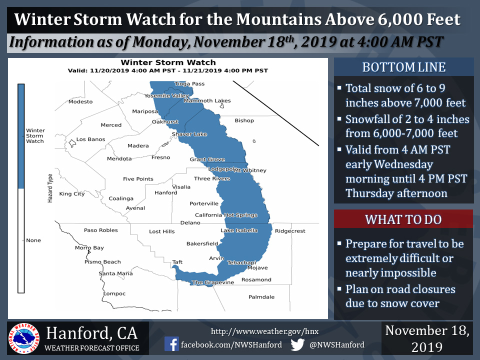
November 18, 2019 - The National Weather Service Hanford Office reports a Winter Storm Watch is in effect for the Southern Sierra Nevada and Kern County mountains above 6,000 feet from 4:00 A.M. early Wednesday morning until 4:00 P.M.Thursday afternoon.
A Winter Storm Watch means there is potential for significant snow accumulations that may impact travel. Snow levels could drop to as low as 5,000 feet in the Kern County mountains Wednesday night.
The majority of this snow will fall Wednesday afternoon and Wednesday evening.
Winds will gust as high as 50 mph on exposed ridgetops and near the crest.
Travel could be extremely difficult or impossible.
If you plan to travel, consider alternate strategies.
If you must travel, remember to carry tire chains, plenty of food, a good deal of water, and warm clothing in your vehicle.
For information on road conditions, including closures or delays, call Caltrans at 1-800-427-7623.
Winter Storm Watch
URGENT - WINTER WEATHER MESSAGE
National Weather Service Hanford CA
351 AM PST Mon Nov 18 2019

Central Sierra-North Kings River-Sequoia Kings-Lake Isabella-
Tehachapi Area-Fort Tejon-
Including the cities of Devils Postpile, Florence Lake,
Lake Thomas Edison, Tuolumne Meadows, Bass Lake, Fish Camp,
Wawona, Shaver Lake, Camp Nelson, Giant Forest, Lodgepole,
Grant Grove, Johnsondale, Lake Isabella, Tehachapi, and Grapevine
351 AM PST Mon Nov 18 2019

...WINTER STORM WATCH REMAINS IN EFFECT FROM LATE TUESDAY NIGHT
THROUGH THURSDAY AFTERNOON...

* WHAT...Heavy snow possible. Total snow accumulations ranging
  from a few inches to as much as 9 inches above 6000 feet. Snow
  levels could be as low as 5000 feet in the Tehachapi mountains.

* WHERE...The Kern county mountains and the southern Sierra
  Nevada.

* WHEN...From late Tuesday night through Thursday afternoon.

* IMPACTS...Snow covered roads...wintry travel...possible road
  closures and travel delays.

* ADDITIONAL DETAILS...Motorists traveling into the higher
  elevations of the mountains during midweek should be prepared
  for adverse weather and winter driving conditions. Hikers and
  campers in the high Sierra should be prepared for accumulating
  snow and much colder temperatures Wednesday through Thursday.

PRECAUTIONARY/PREPAREDNESS ACTIONS...

Please monitor the latest NWS forecasts for updates on this
changing weather pattern.
Source: NWS

