


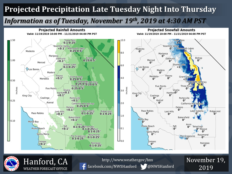
Projected rainfall totals for Mariposa: Zero
Projected rainfall totals for Oakhurst: Less than 0.10"
Projected rainfall totals for Yosemite Valley: Less than 0.10"
November 19, 2019 - The National Weather Service Hanford Office reports an area of low pressure aloft will be in the vicinity of Southern California late Tuesday night into Thursday.
This atmospheric disturbance will likely be responsible for the first precipitation event of the late starting 2019-2020 wet season.
All precipitation below 6,000 feet will be in the form of rain.
A Winter Storm Warning is in effect for the mountains above 6,000 feet.
The majority of this precipitation will fall Wednesday afternoon and Wednesday evening.
  Area Forecast Discussion
  National Weather Service Hanford CA
  138 AM PST Tue Nov 19 2019

  .SYNOPSIS...
  Low pressure will move into the region from the north tonight and
  Wednesday bringing a chance of rain and mountain snow along with
  cooler temperatures. The low will move east on Thursday with a
  return to dry weather.

  &&

  .DISCUSSION...Water vapor imagery shows a tale to two low pressure
  systems along the west coast of North America. A southern low
  pressure system is located near 25N/120W and is pushing moisture
  northward up the Baja Peninsula. Meanwhile, over the Pacific
  Northwest a northern low is moving into Washington with a leading
  mid level trough extending into Northern California. Lots of
  moving parts to the synoptic pattern to say the least. So how does
  this pattern evolve.

  I`ll start with the southern low. Models bring this feature
  and its moisture northeast into Southern Arizona today and tonight
  and for the most part its affects will stay southeast of this
  forecast area. As this takes place, the above mentioned low over
  Washington moves east and a secondary low forms to its west. This
  secondary low is then progged to drop quickly south into northwest
  California by late this afternoon and then down the coast to a
  position near San Luis Obispo by early Wednesday morning. To this
  point, models are very bullish on bringing any precipitation to
  the Central California Interior outside of the Central Sierra
  where some light precipitation is progged on the northeast side of
  the low pressure system.

  By Wednesday morning the low is projected to swing southeast
  across Point Conception and into the LA Basin. With this track,
  the Fort Tejon and Grapevine area could see their first
  precipitation and as the flow into the Sierra becomes more
  easterly, the crest area will see an increase in snow. By
  afternoon the low will eject east towards Las Vegas and some wrap
  around snow will continue over the Sierra Crest. Models
  (especially the ECMWF) keep some lingering wrap around
  precipitation continuing through Wednesday evening before shutting
  off rain and snow chances by Thursday morning as the low heads to
  the east.

  As for precipitation amounts...well you have to start somewhere.
  Over parts of the forecast area, especially the northwest areas
  little to no rain may fall. Over the east side and south end of
  the San Joaquin Valley amounts from just a few hundreths to maybe
  a tenth of an inch are likely. Foothills and mountains are now
  projected to receive up to 0.50-0.60" especially over higher
  terrain. The Kern County Desert areas due to the favorable track
  of the low can expect up to 0.20" of rain by late Wednesday night.

  And finally, for snow...latest projected snowfall totals of up to
  around 10" remain a possibility over the Sierra Crest with higher
  elevations of the Kern County Mountains including the San Emigdio
  range having the potential for up to several inches above 6000
  feet. An early season Winter Storm Warning remains in effect for
  these areas.

  By Thursday afternoon the low is progged to move east with models
  projecting ridging to build in from the north over the weekend.
  Early next week models build another blocking "rex block" pattern
  over the East Pacific with the storm track remaining to the north.
  It won`t take much rain to fall in the SJV to kick off fog season,
  so even if just a little rain falls the fog season could kick off
  this weekend under the stable high pressure aloft.
Source: NWS

