


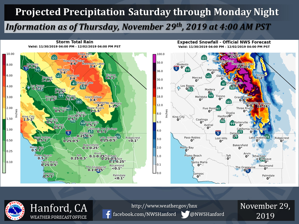
Projected rainfall totals for Mariposa: 3.00" to 4.00"
Projected rainfall totals for Oakhurst: 3.00" to 4.00"
Projected rainfall totals for Yosemite Valley: 4.00" to 6.00"
November 29, 2019 - The National Weather Service Hanford Office reports another strong winter storm system will bring widespread precipitation to the central California interior beginning Saturday Afternoon and continuing through Monday Afternoon.
Significant snowfall will occur over the mountains.
  Area Forecast Discussion
  National Weather Service Hanford CA
  343 AM PST Fri Nov 29 2019

  .SYNOPSIS...
  Steady snowfall in the Sierra Nevada will taper to snow showers as
  a storm system moves away from Central California this afternoon.
  A warmer and wetter storm system will impact the forecast area,
  starting Saturday afternoon and persisting into Monday. Most of
  this precipitation will fall Saturday night through Sunday night.

  &&

  .DISCUSSION...
  An upper-level area of low pressure will be centered near the
  California/Nevada border this morning. This atmospheric
  disturbance may be responsible for an additional four to eight
  inches of snow in the Southern Sierra Nevada this morning.
  Precipitation will become more showery in nature this afternoon as
  the area of low pressure aloft moves to the northeast. An Eastern
  Pacific ridge of high pressure will approach the west coast of the
  United States tonight. This ridge of high pressure will progress
  eastward across California Saturday.

  A storm system will remain offshore of the west coast of the
  United States Saturday night into early next week. Prolonged
  southwesterly flow will continue to feed abundant moisture into
  Central California. This will be a warmer storm system, with snow
  levels around 7000 feet. Three to six inches of rainfall is
  conceivable in the Southern Sierra Nevada foothills and the
  Southern Sierra Nevada below 7000 feet. Forecast confidence is
  increasing regarding the potential for several feet of high
  elevation snow. Rain amounts the San Joaquin Valley will decrease
  from north to south. One to one and a half inches of rain is
  possible in Merced, Madera, and Fresno Counties. One half of an
  inch to inch inch of rain is conceivable in Kings and Tulare
  Counties. One quarter of an inch to one half of an inch of rain is
  possible in Kern County. The majority of precipitation will fall
  Saturday night through Sunday night.

  The aforementioned storm system will finally move onshore Tuesday
  night or Wednesday. Any precipitation Monday night through
  Wednesday should not be heavy. A brief break in precipitation is
  expected Wednesday night through Thursday night as a ridge of high
  pressure progresses eastward through the Western United States.
Source: NWS

