


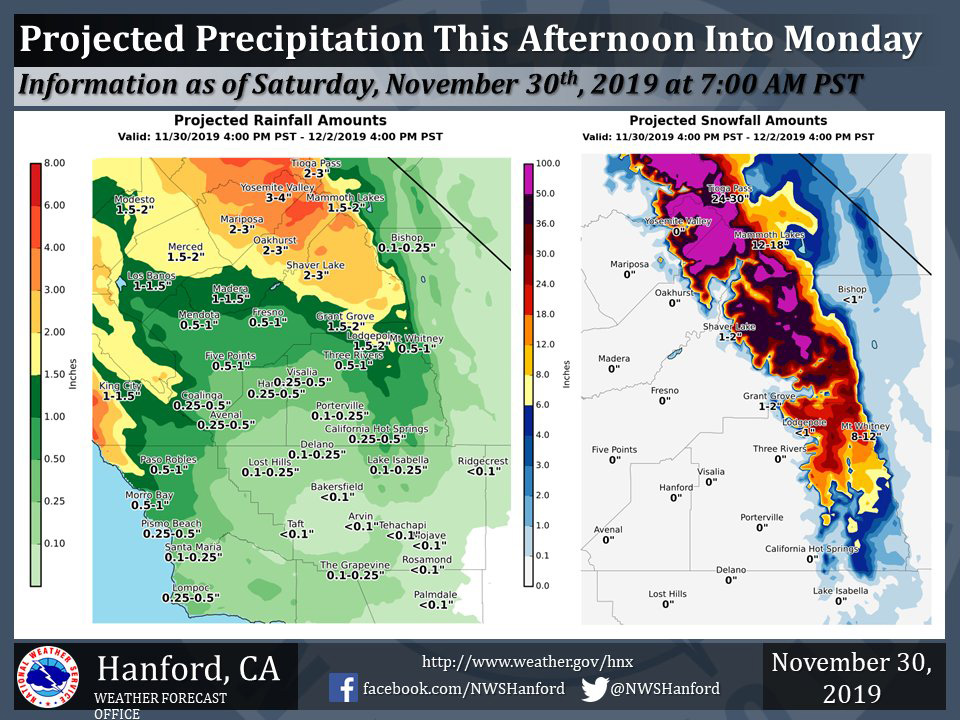
Projected rainfall totals for Mariposa: 2.00" to 3.00"
Projected rainfall totals for Oakhurst: 2.00" to 3.00"
Projected rainfall totals for Yosemite Valley: 3.00" to 4.00"
Note: Graphic Updated at 7:00 A.M.
November 30, 2019 - The National Weather Service Hanford Office reports a storm system will impact Central California this afternoon into Monday.
Several feet of snow will accumulate in the Southern Sierra Nevada above 7,000 feet, where a Winter Storm Warning is in effect.
The heaviest precipitation will remain north of Tulare County.
The majority of this precipitation will fall Sunday.
  Area Forecast Discussion
  National Weather Service Hanford CA
  405 AM PST Sat Nov 30 2019


  .SYNOPSIS...
  An approaching warm and wet storm system will bring heavy snow to
  the Sierra Nevada, heavy rain to the foothills, and moderate rain
  to the San Joaquin Valley starting Saturday afternoon through
  Monday afternoon. The pattern will remain active across the
  region, as another system will effect the area on Tuesday into
  Wednesday.

  &&

  .DISCUSSION...
  For today, a short wave ridge will quickly move through the
  central California interior by late morning. Despite minor
  synoptic warming, abundant high level cloud cover associated with
  the approaching system will keep afternoon high temperatures
  similar to Friday. A negatively tilted trough at 40N/140W will
  continue to dig toward the southeast. This will setup a
  southwesterly flow aloft which will begin to transport subtropical
  moisture into central and northern California in the form of an
  atmospheric river event. Precipitation across the area will
  increase in coverage as the day progresses, with high-res models
  showing the bulk to the precipitation entering the area by the
  late afternoon. However, with the moist southwesterly flow,
  precipitation will begin earlier in the Sierra due to orographical
  enhancement.

  Precipitation will increase in intensity overnight Saturday into
  all day Sunday, with the heaviest of the precipitation occurring
  from Fresno County northward, with lower accumulations expected
  from Kings County southward in to Kern County. Snowfall levels on
  Saturday will begin around 4000 to 5000 feet due to the lingering
  cold airmass across the region. As the warmer, moist air moves
  into the region, snow levels will quickly rise to around 7000 feet
  by Sunday morning.

  A Winter Storm Warning will begin Saturday afternoon and will
  continue into Monday afternoon in the Sierra above 7000 feet where
  snowfall totals will be several feet. In addition to heavy
  mountain snowfall, up to 2 to 4 inches of rain is possible in the
  foothills. When combined with snowmelt from the recent storm,
  flooding will become an issue in the foothills and in the Sierra
  below 7000 feet, with the biggest threat mainly Fresno County
  northward. As such an Flood Watch will remain in effect from
  Saturday afternoon into Monday.

  On Tuesday into Wednesday, long range models show another upper
  level low digging off the CA coast on Tuesday before moving
  through the area on Wednesday. Precipitation will become likely
  across the area by late Tuesday and continue into Wednesday. From
  Thursday through the end of the period on Saturday, our pattern
  will stay active as long range models continue to bring another
  storm system into the region on Friday into Saturday.
Source: NWS

