


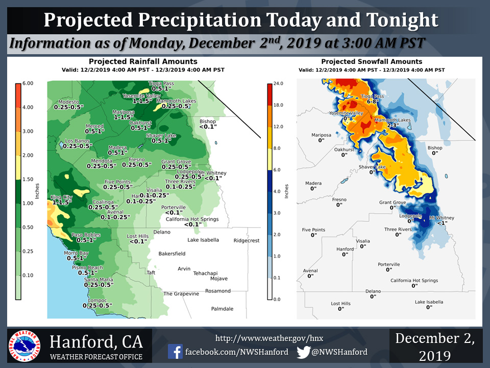
Projected rainfall totals for Mariposa: 1.00" to 1.50"
Projected rainfall totals for Oakhurst: 0.50" to 1.00"
Projected rainfall totals for Yosemite Valley: 1.00" to 1.50"
December 2, 2019 - The National Weather Service Hanford Office reports a plume of enhanced atmospheric moisture will sit over the northern portion of the forecast area today and tonight.
A Winter Storm Warning is in effect for the Southern Sierra Nevada above 7,000 feet, where up to an additional two feet of snow is possible.
The majority of this precipitation will fall today.
  Area Forecast Discussion
  National Weather Service Hanford CA
  315 AM PST Mon Dec 2 2019


  .SYNOPSIS...
  A plume of enhanced atmospheric moisture will sit over the
  northern portion of the forecast area today, resulting in periods
  of heavy rainfall below 7000 feet and abundant snowfall above 7000
  feet. Precipitation amounts will gradually decrease through the end
  of today. Another storm system will begin to affect areas further
  south, such as Kern County areas, on Tuesday night through Wednesday
  night.

  &&

  .DISCUSSION...
  Light to moderate rain continued throughout today across the
  Southern San Joaquin Valley as the advertised atmospheric river
  decided to setup shop from Fresno County northward into Northern
  California. 24 hour rainfall amounts ranged from less than 1/3 of
  an inch in Kings, Kern, and Tulare Counties. Amounts then
  increased to around 2/3 of an inch in Fresno County, up to one
  and a half inches in Merced County. As usual, orographical
  effects increased precipitation amounts in the Central Sierra
  foothills and Mountains, where many several locations received
  between 2 to 4 inches. In addition, very strong winds occurred in
  the Grapevine, with wind gusts up to 80 mph.

  As for our current synoptic setup, not much has changed over the
  last 24 hours. GOES 17 water vapor imagery continues to show deep,
  long fetch of subtropical moisture streaming into the Central
  California interior. This setup will continue through today,
  before ended later this evening. With the moist onshore flow and
  subsequent orographical precipitation enhancement, heavy rain and
  mountain snow will continue to impact the area. An additional 1-2
  inches of rain is possible in the foothills, especially from
  Fresno County northward, as well as one to two feet of additional
  snow through early Tuesday Morning. As such, the Winter Storm
  Warning is continued through Tuesday Morning. Light Precipitation
  will continue across the northern CWA, where additional rainfall
  amounts of up 2/3 of an inch is possible through Tuesday Morning.

  The current upper level low now at 40N/130W will slowly start to
  move southward over the course of today into Tuesday. This low
  will move quickly through the area late Tuesday, and is out by
  Wednesday evening. At this time, model guidance gives
  precipitation totals from late Tuesday into Wednesday afternoon
  ranging from 1/4 to 1/2 of an inch in the valley, and up to one to
  1.5 inches in the Sierra and Kern County mountains. Also, 1/3 to
  2/3 of an inch possible in the Kern County desert. Heavy snowfall
  is expected into the Sierra, where winter weather products will
  have to be considered, or be likely. The biggest uncertainty with
  the precipitation totals is if this next upper level low moves
  faster through the area, reducing precipitation totals. After this
  shortwave trough exits the region, well have ridge transit the
  area on Thursday. For locations in the valley, with abundant
  surface moisture, calm winds, and high pressure aloft, fog will
  start to be an issue on Thursday morning.

  On Friday to the end of next weekend, a deep 530dm low pressure
  drop south from the Gulf of Alaska, before moving slowly eastward
  toward Oregon on Saturday. At this time, long-term models are
  showing precipitation beginning on late friday and extending into
  Sunday afternoon. Models then start to show a ridge setting up by
  the beginning next week with a return of dry weather.
Source: NWS

