


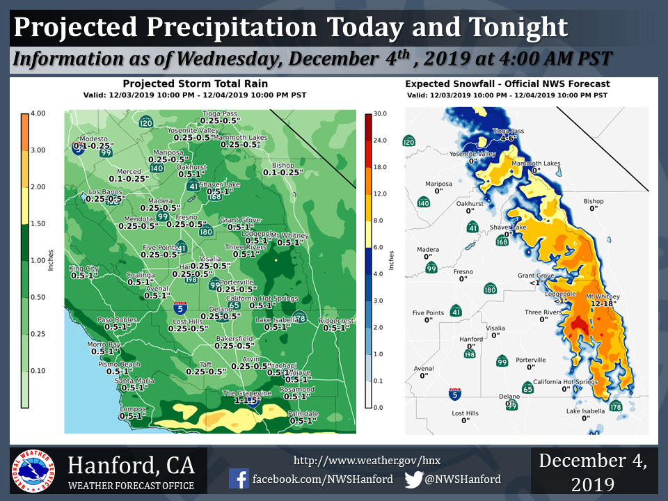
Projected rainfall totals for Mariposa: 0.25" to 0.50"
Projected rainfall totals for Oakhurst: 0.50" to 1.00"
Projected rainfall totals for Yosemite Valley: 0.25" to 0.50"
December 4, 2019 - The National Weather Service Hanford Office reports a storm system will impact Central California today and tonight.
Total snow accumulations of 6 to 12 inches, with isolated amounts up to 18 inches are expected in the Southern Sierra Nevada above 7,000 feet -- where a Winter Weather Advisory is in effect.
The majority of this precipitation will fall from 4:00 A.M. this morning until 4:00 P.M. this afternoon.
  Area Forecast Discussion
  National Weather Service Hanford CA
  450 AM PST Wed Dec 4 2019


  .SYNOPSIS...
  A storm system moving through central California through tonight
  will bring rain and higher elevation snow across the region, with
  the Sierra from Kings Canyon southward getting the most precipitation.
  A few thunderstorms will also be possible this afternoon. A ridge
  of high pressure will then move through the area on Thursday,
  bringing the threat of valley fog. Another weather system will
  affect the district over the weekend.

  &&

  .DISCUSSION...
  An incoming low pressure system is spreading rain and higher
  elevation snow across central CA this morning. snow levels are
  currently running generally around 7 to 8 thousand feet. The
  system is progged to swing inland by this afternoon and as the
  cooler air aloft moves overhead the atmosphere will be
  destabilized sufficiently for the possibility of thunderstorms
  over much of our area. Precipitation will taper off this evening,
  lingering over the mountains into tonight. Latest QPF guidance
  suggests around 1/4 to 1/2 inch in the SJ Valley with 1/2 to 3/4
  in the desert and foothill areas. Amounts climb to over an inch in
  the higher terrain, and with snow levels expected around 7000
  feet, a Winter Weather Advisory is in effect for the mountains
  above 7000 feet from Kings Canyon to the Lake Isabella region.
  Local snowfall amounts up to 18 inches are possible before the
  storm winds down by 10 PM tonight.

  Southerly winds picking up as the storm system approaches this
  morning will gust around 40 to 50 mph in the Kern County mountains
  with a few locations in the Tehachapi`s gusting as high as 55-60
  mph. A High Wind Warning is in effect there through 11 AM this
  morning.

  By Thursday, an amplifying ridge will move inland across our area
  in advance of another developing system approaching from the
  northeast Pacific. This could bring some more SJ Valley fog before
  the incoming low pressure system begins to impact our area Friday.
  Model guidance spreads precipitation southward across our area
  through the weekend as the system tracks inland. Snowfall amounts
  look to be higher with this next system, especially in the mountains
  north of Kings Canyon.

  High pressure is progged to rebuild behind the exiting storm
  system for early next week, bringing drier conditions across our
  area but potentially producing m.ore episodes of San Joaquin
  Valley Tule fog. Temperatures are expected to fluctuate just a few
  degrees either side of seasonal averages throughout the forecast
  period.
Source: NWS

