


California and National Drought Summary for December 3, 2019
Summary
December 5, 2019 - A tandem of winter storms impacted the country during the week, bringing cold temperatures, heavy snow, and strong winds to the mountainous areas of the west, northern Plains, upper Midwest, and Northeast. Lower elevations and latitudes dealt with a combination of weather impacts, including moderate to heavy rainfall in the Southwest, showers and thunderstorms across the South and lower Midwest, and freezing rain to the Mid-Atlantic regions. Another week of above-normal precipitation in the Southwest continued to alleviate the effects of a sub-par monsoon season. In contrast, relatively little precipitation fell in the Northwest, continuing dryness-related impacts such as low streamflow, dry soils, and poor snowpack. Farther east, rain continued to chip away at lingering dryness in the southern Ohio River Valley, Mid-Atlantic, and parts of the Southeast while rainfall amounts in Gulf Coast states were generally not enough to stave off developing dryness.
Northeast
The winter storm near the close of the Drought Monitor week helped alleviate the impacts of a dry November, resulting in the removal of lingering abnormal dryness (D0) from central New Jersey and along the border of West Virginia and Kentucky.
Southeast
This week’s rain continued to reduce coverage of abnormal dryness (D0) and moderate drought (D1) from Virginia to northern Alabama. The two lingering pockets of D2 in northern Georgia saw minimal improvement and persist due to rainfall deficits at timescales longer than 90 days and low streamflow. In contrast, southern Alabama, south Georgia, and Florida all saw an expansion of abnormal dryness as rainfall amounts generally continued to remain below normal. An area of D1 was introduced in South Florida where rainfall amounts have been less than 50 percent of normal over the last 90 days, resulting in low streamflow and dry soils.
South
The South saw a mixture of degradations and improvements. Last week’s rainfall resulted in a general one-category improvement across central Texas, while the eastern part of the state continued to dry out with expansions to areas of abnormal dryness (D0) and moderate drought (D1). An area of extreme drought (D3) was also introduced as precipitation deficits continue to build and impact rangeland. Northwest Oklahoma also saw degradations with an expansion of D0 and D1 as continued dryness combined with last week’s high winds resulted in a wildfire outbreak. Additionally, the U.S. Department of Agriculture reports that the dry weather has dried out topsoil and left winter wheat underdeveloped. Additionally, Arkansas saw expansions to D0, while Louisiana saw expansions in D0 and D1. These areas missed out on the heaviest precipitation and continue to accumulate moisture deficits.
Midwest
More than two inches of rain fell along the eastern border of Kentucky last week, eliminating the remaining area of abnormal dryness (D0) and reducing lingering moisture deficits. The remainder of the region remains drought free after last week’s winter storms.
High Plains
Last week’s winter storms brought widespread snow and winds to the northern Plains leaving the Dakotas. Farther south, precipitation in southern Nebraska and northern Kansas was enough to avoid degradations, but not enough to warrant improvements. Southwest Kansas saw an expansion of abnormal dryness (D0) and moderate drought (D1) in response to continued developing dryness, low streamflow conditions, and impacts to winter wheat. Eastern Colorado was the one area in the region that saw improvements (to areas of D0 and D1) as the result of cold, wet conditions in November.
West
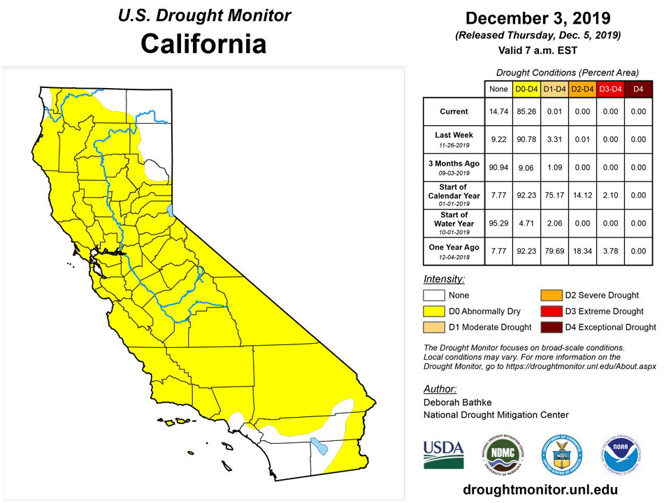
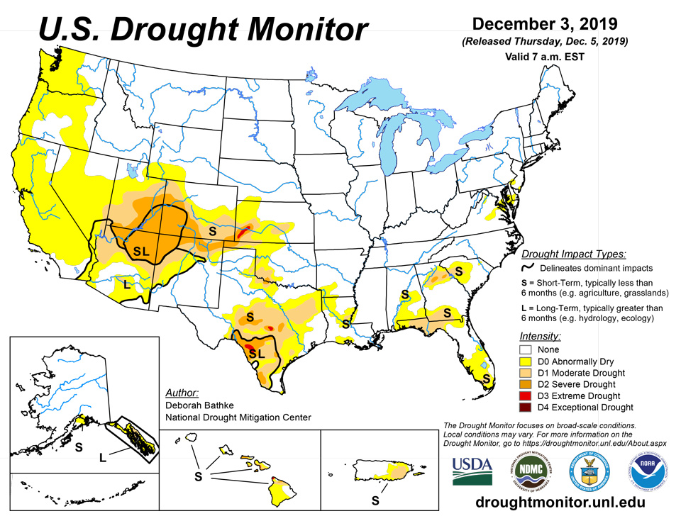
The two storms brought record-breaking precipitation to the Southwest, resulting in widespread one-category improvements across southern and central New Mexico, southern and western Arizona, southern California, southern Nevada, and southwest Utah. Heavy precipitation helped erase short-term precipitation deficits, replenished soil moisture, and improved streamflow conditions. Remaining drought and abnormally dry areas in these regions have been designated with an “L” to denote that dryness is only apparent in longer-term (greater than 4 months) indicators. While beneficial, these events were not enough to allow for improvements to the Four Corners area, which has been experiencing deficits for nearly a year. Despite the significant precipitation, much of California was left in D0 (abnormal dryness) after consultation with the state drought monitoring team. While the precipitation has helped improve conditions, water year to date deficits remain. In contrast, dryness continued to develop in the Pacific Northwest, with parts of Oregon and Washington experiencing among the driest Novembers on record. Precipitation over the last 60 days is less than 50 percent of normal across much of the region, resulting in the expansion of D0.
Alaska, Hawaii, and Puerto Rico
Alaska, Hawaii, and Puerto Rico all saw changes to the map this week. In Alaska, abnormal dryness (D0) was reduced in the south-central part of the state in response to recent precipitation and a general lack of impacts this time of year. D0 remains over the Kenai Peninsula where a snow dearth continues and ephemeral ponds remain dry. Additionally, a continual lack of snowpack in southeast Alaska has resulted in the area remaining in D0 and D1 (moderate drought). Hawaii saw a combination of improvements and degradations. After a dry start to November, rainfall brought relief to parts of Kauai, Niihau, the Big Island, and the southeast lower slope of Maui. Meanwhile, Molokai, the windward slopes of Maui, and Kahoolawe all saw degradation. Puerto Rico also saw a combination of improvements and degradations. While conditions improved on the southwest part of the island, another week of below-normal precipitation left the eastern third of the island with deficits of more than eight inches of rainfall over the past 60 days, resulting in the introduction of moderate drought.
Pacific Islands
A monsoon trough or near-equatorial trough extended across much of Micronesia during most of this USDM week (11/27/19-12/03/19). It extended in a northwest to southeast orientation from the Marianas to southern Marshall Islands (RMI). Three circulations and tropical disturbances moved within it, including Kammuri, a circulation/tropical disturbance in the Federated States of Micronesia (FSM), and a circulation/tropical disturbance across the RMI to eastern FSM. Kammuri brushed the southern Marianas as a tropical storm at the beginning of the week then spent the rest of the week as a typhoon well west of the Marianas and north of Yap and Koror. Shear lines or cold fronts brushed the northern Marianas and RMI during part of the week, and an upper-level low moved near the northern RMI at the end of the week. South of the equator, a surface trough moved over the Samoan Islands at mid- to late week, with drier and more stable air dominating the rest of the period.
Satellite-based estimates of 7-day precipitation (QPE) showed a band of 2+ inches of precipitation stretching from the Marianas to southern RMI associated with the monsoon trough and circulations, with up to 10 inches or more of rain north of Yap and Koror caused by Kammuri. Less than an inch of rain was indicated across south central FSM, and the QPE showed little to no rainfall over Palau, southwestern Yap State, and the northern RMI. An inch or more of rain was indicated by the QPE over the Samoan Islands, with more rain to the west, north, and south, and less to the east and southeast.
Palau had 0.87 inch of rain during this drought week, marking the third consecutive week with precipitation totals much less than 2 inches of rain needed to meet most water needs. However, the monthly November 2019 precipitation total was 11.29 inches, which is over 3 inches more than the threshold of 8 inches to meet most water needs. For this reason, drought-free conditions were unchanged for the Republic of Palau.
The Mariana Islands had an extremely wet week, with precipitation totals above 4 inches, which is more than their monthly threshold of 4 inches to meet most water needs. Guam had the highest precipitation total, receiving 8.27 inches of rain in just one week. Rota followed with 6.66 inches of rain and Saipan with 4.31 inches. Drought development is not a concern for the Mariana Islands.
Chuuk Lagoon, Pohnpei and Kapingamarangi’s drought classification of drought free was unchanged as these stations had over 4 inches of rain during the week, with Chuuk Lagoon having the highest precipitation total (8.55 inches). Ulithi and Yap had 2.14 and 2.41 inches of rain, respectively, and were in drought free status. Kosrae and Nukuoro had less than 2 inches of rain this week, however, both stations had over 8 inches of rain for the month of November, guaranteeing them drought free status. Abnormally dry conditions continue to affect Woleai as this week marked Woleai’s third consecutive week with precipitation totals of 1 inch or less. Meanwhile, Lukunoch had 5.98 inches of rain this week. However, since the last three weeks precipitation totals were less than 2 inches of rain and monthly precipitation totals since September have been less than 8 inches, abnormally dry conditions persisted for another week. Pingelap and Fananu were set to missing due to missing or insufficient data.
Most stations across the Marshall Islands had a wet week, with precipitation totals surpassing their 2-inch weekly minimum. Kwajalein had a total of 7.16 inches of rain, the highest precipitation total across the Marshall Islands this week. Majuro, Ailinglapalap, Jaluit, and Mili had more than 2 inches of rain and continued in drought free status. Utirik and Wotje were the only stations receiving less than the threshold of 2 inches to meet most water needs, with Utirik having the least precipitation at 0.85 inch of rain. Both stations had a November rainfall total above 9 inches, which is more than the 8 inches needed to meet most water needs. For this reason, these two stations also remained in drought free status.
Tutuila received enough rain to remain in drought free status this week, with a total of 1.35 inches of rain. Siufaga Ridge and Toa Ridge also had more than 1-inch of rain for the week at 3.37 inches and 1.60 inches, respectively.
Virgin Islands
Most of the week (November 27-December 3) had no rain reported at Cyril E. King airport. The weekly precipitation for this location was only 0.49 inch of rain, most of which fell on December 2. Similarly, the CoCoRaHS station at Anna’s Retreat 2.5 ESE had 0.21 inch of rain for the week and 1.73 inches for the month of November. The November 2019 rainfall total at Cyril E. King airport was 3.15 inches, which is 2.08 inches below average or 60.2% of normal precipitation. The year-to-date precipitation total of 32.69 inches is 89.0% of normal precipitation. The SPI value for 1 and 3 months are -1.01 and -1.12, indicating moderate drought. However, the 6 (0.01), 9 (-0.34), and 12 (-0.43) months are consistent with drought free conditions. Groundwater levels at the Grade School-3 Well continued to drop from 3.91 feet on September 10 (the smallest depth to water level below land surface in 2019) to 10.63 feet below land surface on December 3. This week drought free conditions remained unchanged for St. Thomas, however, abnormally dry conditions might be introduced next week if dry conditions persist.
St. Croix also had less than an inch of rain this week. The Henry E. Rohlsen airport reported only 0.21 inch of rain, while the Christiansted 1.8 ESE CoCoRaHS station had a weekly rainfall total of 0.64 inch. The monthly precipitation total for November was 2.5 at the CoCoRaHS station and 2.63 inches (or 48% of normal precipitation) at the airport. The year-to-date rainfall total at the airport was 22.11 inches or 61.5% of normal precipitation. SPI values for 1 and 3 months were -1.64 and -1.89, typically representing extreme drought. The 6, 9, and 12 months SPI values of -1.31, -1.07, and -1.54, respectively, are indicative of moderate to severe drought conditions. The Adventure 28 Well had groundwater at 20.31 feet below land surface, which is a decrease from the start of the year (15.48 feet below land surface). Moderate drought (D1-SL) remains unchanged for St. Croix this week.
St. John had only 0.64 inch of precipitation for the week. Similarly to St. Thomas, most of that precipitation (0.63 inch) fell on December 2. Overall, the November 2019 precipitation total of 1.94 inches was 26.9% of normal precipitation and the third driest November since records began in 1984. Only Novembers of 1995 (1.61 inches) and 2006 (1.89 inches) were drier. The year-to-date precipitation of 34.02 inches is 76.5% of normal. The SPI values for the 1 and 3 months were -1.45 and -1.56, representing severe drought. While the SPI values for 9 and 12 were -0.62 and -0.98, representing abnormally dry to moderate drought conditions. Ground water levels at the Susannaberg DPW 3 Well groundwater had gone up in September 2019 to 11.39 feet below land surface from 15.67 feet below land surface in late August. However, groundwater level has been declining once again and it was 13.18 feet below land surface as of December 3. St. John’s drought classification remained as abnormally dry conditions; however, moderate drought conditions might be considered next week if dry conditions persist.
Looking Ahead
According to the National Weather Service Weather Prediction Center forecast for the remainder of the week, a storm is expected to bring rain and higher elevation snow to the West Coast, with the highest totals focused over northern California, the southwest corner of Oregon, and the Sierra Nevada. Other areas of the West will likely see lesser amounts. Farther east, cold air moving over the Great Lakes is expected to generate bands of lake effect snow. Elsewhere, dry conditions should be in place for the remainder of the week. By early next week, precipitation will begin to develop over the eastern half of the country with the heaviest amounts favored over portions of the Tennessee Valley, southern Appalachians, and parts of the Ohio River Valley and Mid-Atlantic.
The Climate Prediction Center 6 to 10 day outlook for December 9-13 calls for an outbreak of cold arctic air across the across the lower 48 with temperature departures approaching -15 degrees Fahrenheit. The weather pattern favors above-normal temperatures over Alaska and the West Coast. Variable temperatures are expected along the East Coast. Precipitation is expected to be above normal for most of country, with the exception of California and the Southwest.
Author(s):
Deborah Bathke, National Drought Mitigation Center
Ahira Sanchez-Lugo, NOAA/NCEI
Dryness Categories
D0 Abnormally Dry—used for areas showing dryness but not yet in drought, or for areas recovering from drought.
Drought Intensity Categories
D1 Moderate Drought
D2 Severe Drought
D3 Extreme Drought
D4 Exceptional Drought
Drought or Dryness Types
S Short-Term, typically less than 6 months (e.g. agricultural, grasslands)
L Long-Term, typically greater than 6 months (e.g. hydrologic, ecologic)
Source: National Drought Mitigation Center

