


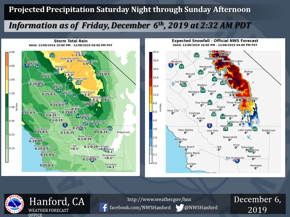
Projected rainfall totals for Mariposa: 2.00" to 3.00"
Projected rainfall totals for Oakhurst: 1.50" to 2.00"
Projected rainfall totals for Yosemite Valley: 2.00" to 3.00"
December 6, 2019 - The National Weather Service reports a storm system will bring rain and mountain snow to much of the Central California Interior Saturday evening through Sunday afternoon.
Snow will fall generally above 6000 feet.
  Area Forecast Discussion
  National Weather Service Hanford CA
  315 AM PST Fri Dec 6 2019


  .SYNOPSIS...
  A ridge of high pressure will continue today with warm and dry
  conditions. Patchy fog will threaten the valley through the
  morning hours. Afterward, another weather system will affect the
  district over the weekend. Winter weather will return as rain and
  snow will once again blanket the Central California Interior for
  much of the weekend.

  &&

  .DISCUSSION...
  A weak short-wave ridge is currently crossing the region while a
  jet max moves through Southern California. The ridge gave the
  Central California Interior clear skies on Thursday and today
  while the jet max is also providing for locally breezy conditions
  and some higher clouds cover. While there is still a slight
  potential for fog this morning, enough mixing from the strong
  winds aloft will keep the fog at a minimum. Satellite Fog-Product
  imagery, along with surface observations, is showing very spotty
  lower visibility that may only extend to a few more spots this
  morning. Whatever fog does form will quickly burn off by midday.
  One other note about the jet max is that some of the higher wind
  speeds are mixing down the mountain levels of Central California.
  Currently, local mountains are already indicating strong winds at
  their ridge-top locations. Wind advisories have been issued for
  areas favored in the current weather pattern. In addition, the
  storm currently off the Pacific Northwest Coast will be the major
  weather maker this weekend as more rain and snow is expected
  across Central California.

  Model confidence remains high as yet another storm across
  California during the weekend. Currently, IR satellite imagery
  continues to show a well developed system off the Northwest
  Pacific Coast. While a secondary band associated with a jet max is
  producing winds and high clouds, the main storm is now pushing
  into the Pacific Northwest and extreme Northern California.
  Organized precipitation is still expected to enter Central
  California later this evening. The initial precipitation will be
  from warm frontal overrunning ahead of the cold front expected to
  enter the region on Saturday. Therefore, will see light
  precipitation tonight with the heavier accumulations on Saturday.
  Furthermore, the warm front will introduce higher snow levels as
  snowfall accumulation will remain above 7000 feet before snow
  levels lower in the post cold frontal environment as they reach
  near 5000 feet by Monday. Currently, a Winter Storm Warning
  remains in effect for the Sierra Nevada as heavy snow could fall
  from late Friday night through Sunday morning for areas above 6000
  feet.

  By Monday, models do show some timing issues on the exit of the
  weekend storm. While model uncertainty is higher on how fast the
  storm will exit, they agree that the storm will exit around the
  Monday time-frame as another ridge pushes through the area. Will
  keep Monday and Tuesday dry during the passage of the upper level
  ridge before another weaker disturbance attempts to enter the
  region. Models showing very low confidence that the disturbance
  entering the region after the weekend has the potential of
  producing precipitation. Therefore, will continue the trend of a
  dry forecast for the Wednesday and possibly Thursday time-frame.
  Once the longer period dry and quiet weather pattern begins, fog
  will become a bigger problem which came become widespread across
  the San Joaquin Valley. Winter is quick approaching and fog will
  become a reality as we get deeper into December.
Source: NWS

