


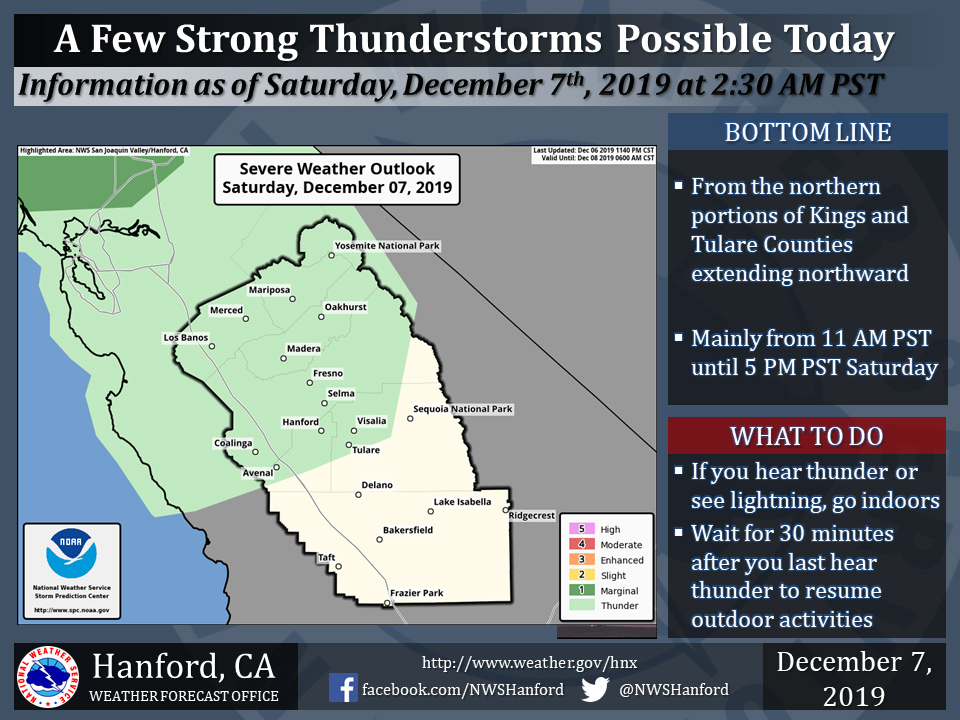
December 7, 2019 - The National Weahter Service Hanford Office reports a few strong thunderstorms are possible in Central California today from the northern portions of Kings and Tulare Counties extending northward.
Funnel clouds, small hail, and wind gusts near 40 miles per hour are some of the hazards associated with strong thunderstorms.
In addition to dangerous cloud to ground lightning strikes, any thunderstorm can produce intense rainfall rates, leading to localized flooding.
  Area Forecast Discussion
  National Weather Service Hanford CA
  235 AM PST Sat Dec 7 2019

  .SYNOPSIS...
  A weather system will affect the district from late tonight
  through the end of the weekend with rain and thunderstorms in the
  valley, along with heavy rain and snow into the Central Sierra.
  foothills and mountains. Ridge will build into the area for
  Monday and Tuesday, with morning fog possible. Quick, dry short
  wave moves through Central California on Wednesday, before ridge
  builds across the area into the end of next week.

  &&

  .DISCUSSION...Radar shows just some isolated showers over the
  forecast area as the first wave of a three part system lifts to
  the northeast. This weekends storm system will come in three parts
  as shown nicely on water vapor satellite imagery. The first
  impulse is lifting quickly northeast into the Sierra early this
  morning and a second wave is noted just now moving into areas just
  north of San Francisco. A third, and most impressive vorticity
  feature is now crossing 37N/130W and moving rapidly to the west.

  So how do these impulses affect the weather across the Central
  California Interior? I`ll start with the first disturbance moving
  into the Sierra, this will exit to the east early this morning
  leaving a lull in precipitation. The second wave now moving into
  the North Bay will sweep through mainly the northern parts of the
  forecast area after sunrise and will bring another increase in
  precipitation through about mid day. This will then be followed by
  impulse number three which is progged to arrive on the coast early
  this evening and sweep southeast tonight and early Sunday. Enough
  instability exists for a couple of thunderstorms to form over the
  north.

  The last weather feature that will bring precipitation to the
  forecast area will be the low center itself, which models prog to
  drop southeast down the state on Sunday bringing showery
  conditions.

  Given the total expected precipitation in the Sierra with all of
  these weather disturbances, snow will accumulate easily to winter
  storm conditions especially from Kings Canyon Park northward. Snow
  levels will generally remain at around 7000 feet today but will
  fall to around 5500 feet on Sunday as the colder air arrives with
  the low pressure center.

  The low moves east of the area Sunday night and Monday with a
  ridge of high pressure projected to build over the area and
  persist into Tuesday before a weakening shortwave trough moves
  across Northern California Tuesday night and Wednesday. This last
  system should bring just an increase in clouds but no
  precipitation. Fog will become an issue over the San Joaquin
  Valley Monday and Tuesday mornings however enough cloud cover
  should accompany the mid week shortwave through to limit fog
  formation Wednesday.

  A period of dry weather will continue into late next week as
  models build a strong high pressure system over the East Pacific
  and push the storm track well to the north into next weekend. Dry
  and mainly clear weather will persist in all areas outside the
  San Joaquin Valley where fog, inversions and potentially cloudy
  weather is climatologically favored in this pattern this time of
  year.
Source: NWS

