


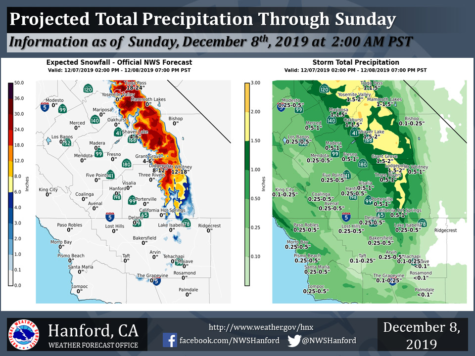
Projected rainfall totals for Mariposa: 1.00" to 1.50"
Projected rainfall totals for Oakhurst: 1.00" to 1.50"
Projected rainfall totals for Yosemite Valley: 1.50" to 2.00"
December 8, 2019 - The National Weather Service Hanford Office reports a storm system will continue to impact Central California today.
Total snow accumulation of one to three feet are likely in the Southern Sierra Nevada above 6,000 feet, where a Winter Storm Warning is in effect.
  Area Forecast Discussion
  National Weather Service Hanford CA
  156 AM PST Sun Dec 8 2019


  .SYNOPSIS...
  A weather system will affect the district through this evening.
  A ridge of high pressure will build into the area for Monday and
  Tuesday, with morning fog possible. Quick, mainly dry short wave
  moves through Central California on Wednesday, before ridge builds
  across the area into the end of next week.

  &&

  .DISCUSSION...
  Radar shows the main area of precipitation from the latest short
  wave now pushing across Fresno, Kings and Tulare counties as the
  wave moves east to southeast across the Central California
  Interior. High resolution short range models continue to drive
  this precipitation band to the southeast overnight with the bulk
  of it reaching Bakersfield and the Kern County Mountains after 7
  AM.

  As the center of the low pressure system moves southeast
  across the forecast area today...a showery pattern will persist
  with cold air aloft providing enough instability for a few low
  topped thunderstorms over mainly the San Joaquin Valley and
  foothills this afternoon. There should be enough coverage of these
  developing and passing showers to keep chances of precipitation
  moderate all day however it certainly will not be a constant rain
  or snow event in the Sierra.

  As for continued snow threat in the Sierra, model projected
  precipitation suggests several inches or more of snow will fall
  above 6000 feet today thus the winter storm warning will remain in
  place through early evening.

  By later this afternoon and early evening...models move the low
  pressure trough southward into Southern California and this will
  effectively end the precipitation for Central California. On
  Monday, a sharp ridge of high pressure is progged to build down
  the West Coast with the ridge holding into Tuesday. This scenario
  will provide dry and warming weather for all areas outside the San
  Joaquin Valley where...you guessed it...patchy fog will form
  Monday morning with the threat of widespread fog Tuesday morning.
  Should see lower level inversion conditions increase during this
  time frame and afternoons will become more hazy in the lower
  elevations.

  Models then bring a weak short wave trough into the ridge on
  Tuesday night and Wednesday and some light precipitation may reach
  into the Yosemite area but little chance will exist to the south.
  The pattern looks to remain dry beyond Wednesday as the storm
  track is pushed well to the north due to strengthening high
  pressure west of Baja and Southern California later in the week.
  Looks like the ridge will keep things dry well into next weekend
  with again, mainly clear and warming weather for everyone outside
  the SJV where fog, low clouds and cool temperatures are a frequent
  product of this synoptic pattern in mid December.
Source: NWS

