


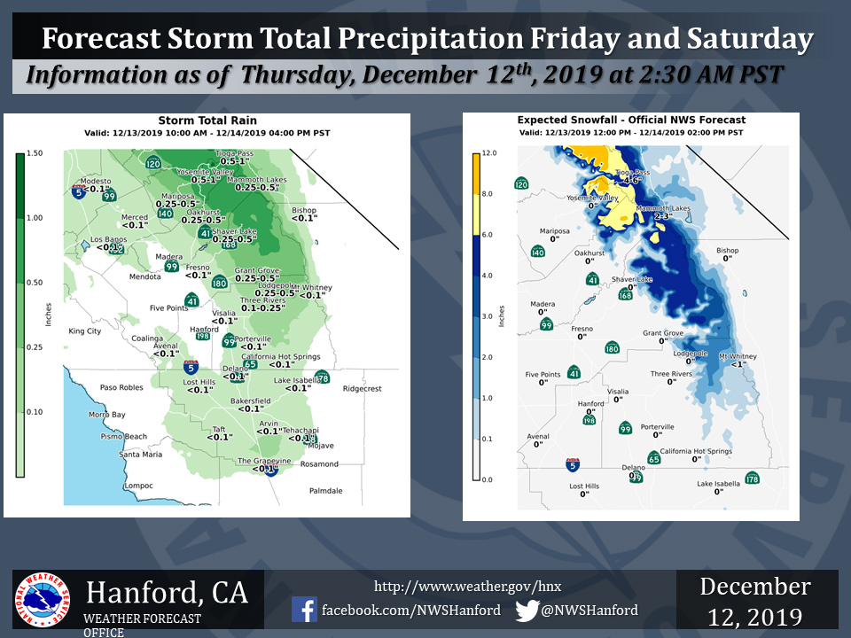
Projected rainfall totals for Mariposa: 0.25" to 0.50"
Projected rainfall totals for Oakhurst: 0.25" to 0.50"
Projected rainfall totals for Yosemite Valley: 0.50" to 1.00"
December 12, 2019 - The National Weather Service Hanford Office reports a storm system will bring rain and mountain snow to parts of the Central California Interior Friday morning through Saturday afternoon. Snow will fall generally above 7000 feet.
  Area Forecast Discussion
  National Weather Service Hanford CA
  324 AM PST Thu Dec 12 2019

  .SYNOPSIS...A few light showers are possible over Yosemite NP
  today. Otherwise, high pressure will provide dry weather with
  dense fog across the San Joaquin Valley overnight and into the
  morning. Another Pacific storm system will bring more wet weather
  Friday afternoon through the weekend, mainly over the mountains.

  &&

  .DISCUSSION...
  The main weather concern tonight is once again dense fog across
  the San Joaquin Valley. Unfortunately, plenty of high clouds are
  making it difficult to utilize the GOES-17 satellite Night Fog
  product. But based on surface observations and webcams, coverage
  is less than the previous couple of nights. Nonetheless, patches
  of dense fog have developed, mainly along the Hwy 198 corridor
  from Lemoore to Visalia. Also, the HRRR model shows visibility
  decreasing across Fresno, Madera and Merced Counties through the
  early morning. Thus, a Dense Fog Advisory has been issued for the
  SJ Valley north of Kern County until 10 AM this morning.

  Broad upper ridge west of Baja CA remains in control but there is
  a very moist westerly flow aloft on the north side of the ridge.
  PWAT values around 1.25" are advecting in over the Bay area and
  with weak energy aloft, scattered showers have been developing
  over the Sierra Nevada in northern California. There were a few
  light showers that clipped Yosemite NP last evening and this will
  be possible again today. Any precipitation would be very light
  with generally less than a tenth of an inch expected.

  The ridge loses it`s grip a bit on Friday as an upper trough takes
  aim on the Pacific Northwest. This shifts the storm track farther
  south over central CA with precipitation arriving around Yosemite
  NP by late morning. Models show precip spreading southward through
  the day and into Kern County overnight into Saturday morning. QPF
  gives from 0.5" to 1" liquid around Yosemite NP. Snow levels start
  out around 8000 feet on Friday then lower to around 7000 feet late
  night and near 6000 feet by Saturday morning as the precipitation
  tapers off. Given this, have issued a Winter Weather Advisory for
  the Central Sierra zone (192) above 7000` from Noon Friday until
  10 AM Saturday. Total snow accumulations of 4 to 8 inches with
  localized amounts up to 10 inches is forecast. QPF farther south
  is 0.25" to 0.5" for Sequoia/Kings Canyon NP; and 0.1" to 0.2"
  down into the Kern County Mountains. Rainfall across the SJ Valley
  is expected to be very light with generally only a few hundredths
  to a tenth of an inch.

  A few showers may linger through Saturday and into the evening
  then the aforementioned trough is expected to drive inland over
  NorCal and the Great Basin Saturday night into Sunday morning.
  This should bring a fairly quick shot at some more precipitation
  but it will not have the rich subtropical moisture plume to work
  with anymore. Though we do not expect significant amounts with
  this system, snow levels could be down around 4000 feet by Sunday
  morning. Gusty winds will develop through the mountain passes in
  Kern County this weekend and may reach advisory levels on Sunday.

  Dry conditions are forecast Sunday night into early next week as
  an upper ridge builds in from the Pacific. Models agree with an
  upper low offshore of California next Tuesday but diverge from
  there. The latest GFS moves it inland on Wednesday with healthy
  QPF depicted over central CA; similar to the GFS Ensemble mean.
  But the Euro and Canadian models keep it offshore until Thursday
  and are much lighter with the precip.
Source: NWS

