


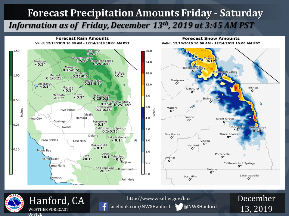
Projected rainfall totals for Mariposa: 0.25" to 0.50"
Projected rainfall totals for Oakhurst: 0.25" to 0.50"
Projected rainfall totals for Yosemite Valley: 0.50" to 1.00"
December 13, 2019 - The National Weather Service Hanford Office reports a storm system will bring rain and mountain snow to parts of the Central California Interior Friday morning through Saturday morning.
Snow will fall generally above 7000 feet.
  Area Forecast Discussion
  National Weather Service Hanford CA
  154 AM PST Fri Dec 13 2019


  SYNOPSIS...
  A disturbance will bring mountain snow today and tomorrow for the
  northern portion of the Southern Sierra Nevada. A second
  disturbance will usher in cooler air, light precip, and gusty
  desert winds Saturday night through Sunday. Ridging Monday and
  Tuesday will keep weather quiet before another possible storm
  system impacts Central California mid week next week.

  &&

  .DISCUSSION...
  Latest Goes 17 satellite nighttime imagery reveals patchy areas
  of dense fog in the western portion of the San Joaquin Valley
  early this morning as the ridge of high pressure that has been
  over us the last few days begins to shift south. CHP reports of
  car accidents and local web cams reveal low visibility in fog, so
  have issued a Dense Fog Advisory until 10 AM for the western
  portion of the San Joaquin Valley. Upper level model progs show a
  disturbance beginning to impact Yosemite NP by 10 AM this morning.
  This disturbance will bring high elevation snow to the Sierra
  Nevada today and tomorrow, with snowfall totals of 4-8 inches of
  snow possible above 7000 feet through 10 AM Saturday morning, with
  local amounts of 10-12 inches possible along the crests. A Winter
  Weather Advisory remains in effect through 10 AM Saturday for the
  Southern Sierra Nevada above 7000 feet for Florence Lake and
  northward. In the SJ Valley, precipitation is expected to spread
  southward Friday night into Saturday morning, but accumulations
  look to be very light, with QPF totals only around 0.1".

  Another disturbance will move inland bringing cooler air, light
  precip, and gusty winds through and below the Kern County Mountain
  Passes. Snow levels will fall to 3500-4000 feet by Sunday, but
  this system will but cut-off from a rich moisture source, so QPF
  totals will be scant. The winds in the Kern Co Desert will
  probably be near or at Advisory level by Saturday
  afternoon/evening, which may make travel difficult for high
  profile vehicles.

  Monday and Tuesday look to have calm weather as models build a
  ridge of a high pressure aloft above Central California. Another
  disturbance looks to be aimed at us by mid week next week,
  however, there is significant disagreement on the timing of the
  next trough. The EC ensemble is slower and farther south than the
  GEFS with this system, so the impacts of this trough are
  uncertain as of this writing. Details will be ironed out in the
  coming days.
Source: NWS

