


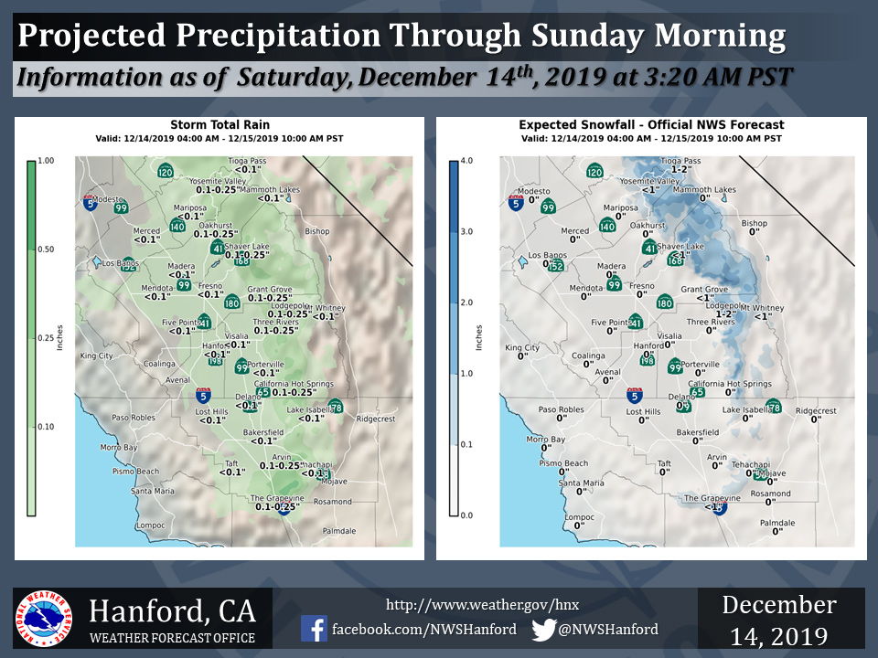
Projected rainfall totals for Mariposa: Less than a 0.10"
Projected rainfall totals for Oakhurst: 0.1" to 0.25"
Projected rainfall totals for Yosemite Valley: 0.1" to 0.25"
December 14, 2019 - The National Weather Service Hanford Office reports a storm system will continue to bring additional rain and mountain snow to parts of the Central California Interior through Sunday morning.
Snow will fall generally above 7000 feet. Here are the latest projected rain and snowfall amounts.
  Area Forecast Discussion
  National Weather Service Hanford CA
  325 AM PST Sat Dec 14 2019


  .SYNOPSIS...An upper level system will bring a chance of rain and
  mountain snow through Saturday morning. A second system will
  usher in cooler air, light precipitation, and gusty desert winds
  Saturday afternoon through early Sunday. Ridging Monday and
  Tuesday will keep weather quiet before another possible storm
  system impacts Central California during the middle of next week.

  &&

  .DISCUSSION...Mainly zonal flow prevails over Central California
  with a few showers at this time. Otherwise, mid and high clouds
  continue to stream onshore. Expect showers to taper off later
  this morning, at least in the Central Valley. An ongoing chance of
  mountain precipitation continues through this evening into Sunday
  morning as another trough passes over Northern California into
  the Great Basin, or as an inside slider. We`re not anticipating
  much precipitation for the remainder of this weekend. However,
  gusty winds are likely in the Tehachapi Mountains and the Kern
  County desert areas, with the strongest gusts below the passes and
  canyons. Gusts to 55 mph are likely in these areas, although some
  locally stronger gusts are possible at times this evening and
  overnight into Sunday morning. Cooler overnight low temperatures
  are expected both Sunday and Monday mornings in much of our
  forecast area.

  While weather will be relatively quiet on Monday and Tuesday, fog
  development in the San Joaquin Valley will be a possibility
  during the nights and mornings. Otherwise, seasonal to slightly
  below average daytime temperatures will prevail during this
  period.

  By Wednesday morning, the next storm system arrives. The upper-
  level low and associated trough are projected to pass over Central
  and Northern CA until the afternoon and will be over the Great
  Basin by Wednesday evening. There are some notable model
  differences in terms of moisture, but it appears precipitation
  will be generally light with this next system.

  Another period of ridging is possible late in the week, and yet
  another storm system is possible by next weekend. However, there
  are significant differences in the latest model runs in terms of
  both strength and timing with this next system. More details to
  follow as we get closer.
Source: NWS

