


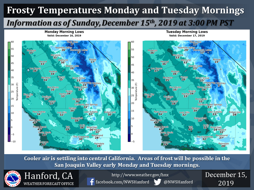
Mariposa Projected Low Temps for Monday at 31 Degrees and Tuesday at 33 Degrees
Oakhurst Projected Low Temps for Monday at 30 Degrees and Tuesday at 33 Degrees
Yosemite Valley Projected Low Temps for Monday at 26 Degrees and Tuesday at 29 Degrees
December 16, 2019 - The National Weather Service reports a cooler air mass settling into central California will bring lower overnight minimum temperatures across the area.
Areas of frost can be expected over much of the San Joaquin Valley early Monday and Tuesday mornings as lows dip into the low and mid 30s.
  Area Forecast Discussion
  National Weather Service Hanford CA
  123 AM PST Mon Dec 16 2019


  .SYNOPSIS...
  High pressure over Central California over the next two days will
  keep weather dry before another storm system impacts the region
  bringing light precip to the area. Gusty winds in Kern County
  will be the main weather impacts this work week on Tuesday. Dry
  quiet weather late in the work week before a more potent system
  impacts the forecast area this weekend.

  &&

  .DISCUSSION...
  Cooler and drier airmass over the forecast area this morning will
  allow for cooler temperatures this morning with many areas in the
  San Joaquin Valley hitting mid to low 30`s. Areas of patchy frost
  may develop in the lowest elevations of the valley as a result.
  High pressure aloft moving into the region will allow for clear
  skies today and high temperatures are expected to reach into the
  mid 50`s. The ridge of high pressure will build over the CWA
  Monday and Tuesday, fostering a strong offshore gradient. This
  will allow for increasing winds in Kern County -- main the Fort
  Tejon/Tehachapi/Grapevine areas -- by late Monday/Tuesday morning
  throughout early Wednesday morning. Strong east to southeast winds
  will occur during this time frame, so we have issued a High Wind
  Watch from 09z Tuesday through 12z Wednesday.

  The next disturbance that is progged to impact our forecast area
  by Wednesday will have scant precip totals. QPF totals of on a few
  hundreths of an inch are forecast by current blended model
  guidance in both the Sierra Nevada and western portion of the SJV.
  Medium range models are in good agreement that a high pressure
  pattern will resume late in the work week over the forecast area.
  High temperatures are forecast to climb Thursday through Saturday
  in the San Joaquin Valley before the next storm system arrives.
  Currently, high temperatures in the low 60s and mid to upper 60s
  are forecast to occur for the north/central and southern portion
  of the valley accordingly by Saturday.

  Finally, Saturday night through Monday are progged to be the next
  active weather period for Central California. Models are in pretty
  good agreement of a trough of low pressure bringing an
  appreciable amount of precipitation across the forecast area.
  However, QPF totals are still somewhat unclear this far out.
  Details will become clearer in future forecast packages as the
  event draws nearer.
Source: NWS

