


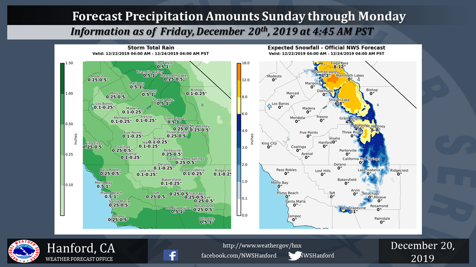
Projected rainfall totals for Mariposa: 0.50" to 1.00"
Projected rainfall totals for Oakhurst: 0.50" to 1.00"
Projected rainfall totals for Yosemite Valley: 0.50" to 1.00"
December 20, 2019 - The National Weather Service Hanford Office reports a storm system will bring periods of rain and mountain snow to the Central California Interior Sunday morning through Monday night.
Snow will fall generally above 4500 feet in the Sierra north of Kings Canyon and above 5500 feet over the mountains of Tulare and Kern counties.
Above are the latest projected rain and snowfall amounts.
  Area Forecast Discussion
  National Weather Service Hanford CA
  343 AM PST Fri Dec 20 2019

  .SYNOPSIS...Dry weather and mild afternoon temperatures
  can be expected over the district through Saturday. A
  storm system will bring rain and high elevation snow to
  the region from midday Sunday into Monday night along
  with cooler temperatures. Christmas Eve will be dry except
  for a few residual showers over the mountains and desert.
  Rain and mountain snow will return by Christmas Day and
  linger into Thursday.

  &&

  .DISCUSSION...A change to a stormy weather pattern will
  become established over the Golden State later this weekend
  and it will likely remain pretty active through the end of
  next week with frequent bouts of precipitation. There are
  at least a few storms that will impact the central California
  interior during the next 7 days. Each of them will bring
  rain to the lower elevations and snow to the mountains. By
  this time next week, we can confidently claim that the Sierra
  snowpack will be deeper than it is now and additional rain
  that falls in the lower elevations will keep precipitation
  totals at or above their seasonal norms in many locations.

  Through tomorrow, however, our weather will be relatively
  pleasant by December standards, thanks to a dry southwesterly
  flow aloft over central California and an upper level ridge
  of high pressure over the Desert Southwest. There`s a good
  deal of cirrus embedded in the southwesterly flow, but even
  with sunshine filtering through these high clouds, high
  temperatures will run several degrees above normal in most
  areas through Saturday. In some locations of the south valley
  and lower foothills, thermometer readings could warm into the
  lower 70s Saturday afternoon. Additionally, southerly winds
  will become gusty over the Kern county mountain passes Saturday
  and could gust to 45 mph or so over the Grapevine and along the
  valley facing slopes of the Tehachapi mountains Saturday afternoon
  into Sunday morning ahead of the next approaching storm system.
  A Wind advisory may be necessary for this region if we feel gusty
  winds will be more widespread than we`re currently thinking. This
  might be the only initial impact of our approaching storm system
  this weekend.

  A Pacific cold front associated with that storm will move inland
  across the CWA Sunday afternoon and evening with its
  precipitation. Snow levels will range from about 4500 feet in
  the Sierra north of Kings Canyon to about 5500 feet over the
  mountains of Tulare county and Kern county Sunday. Although the
  upper level trough behind this front remains offshore, it will
  still bring at least a chance of showers to much of the CWA
  Sunday night into Monday as it gravitates southward into southern
  California. The front could actually stall for a time over the
  Kern county mountains and desert later this weekend, especially
  if the upper level trough remains farther offshore. If so,
  precipitation totals will be a little higher than we`re currently
  forecasting. Otherwise, by the time this storm system exits east
  of our CWA Monday night, we can expect rain totals of around a
  quarter of an inch in the San Joaquin Valley and the Kern county
  desert with totals of a half inch to three quarters of an inch
  in the mountains. The storm will likely bring a few to several
  inches of snow to the mountains. Up to a foot of new snow is
  possible over the highest elevations of the Sierra around
  Yosemite with wintry impacts for motorists, hikers and campers
  late in the weekend into early next week.

  We should get a break from wet weather, albeit brief on Christmas
  eve as a weak short wave ridge of high pressure settles over the
  district. Another storm will be right on the heels of our late
  weekend storm and it will likely bring a return of rain and
  mountain snow to the central California interior Christmas Day
  into Thursday. This will be a colder storm with the possibility
  of accumulating snow at elevations as low as 3,000 feet during
  the Christmas holiday. Specific details on snow amounts and rain
  totals on this storm will depend on the track of this storm. The
  ECM keeps it offshore while the GFS brings it inland. Whatever
  the case, there will be additional wintry impacts for hikers and
  motorists along with possible travel delays.

  The models come back into agreement by late Thursday and forecast
  another short wave ridge to move in over central California. This
  should provide the district with another brief, precipitation-free
  period Thursday afternoon through Thursday night. Afterward, the
  models forecast another storm with a more inland track that could
  brush the mountains and desert with additional precipitation next
  Friday. At this time, the storm on day 7 looks like it will bring
  little if any additional impacts for holiday travelers. One thing
  we`re more certain of is the return to colder weather next week.
  Monday through Friday will be more seasonable and perhaps
  slightly below normal, temperature-wise, Christmas Day and the
  day after Christmas. How appropriate is that?  After all, Winter
  officially begins Saturday at 8:19 pm PST.
Source: NWS

