


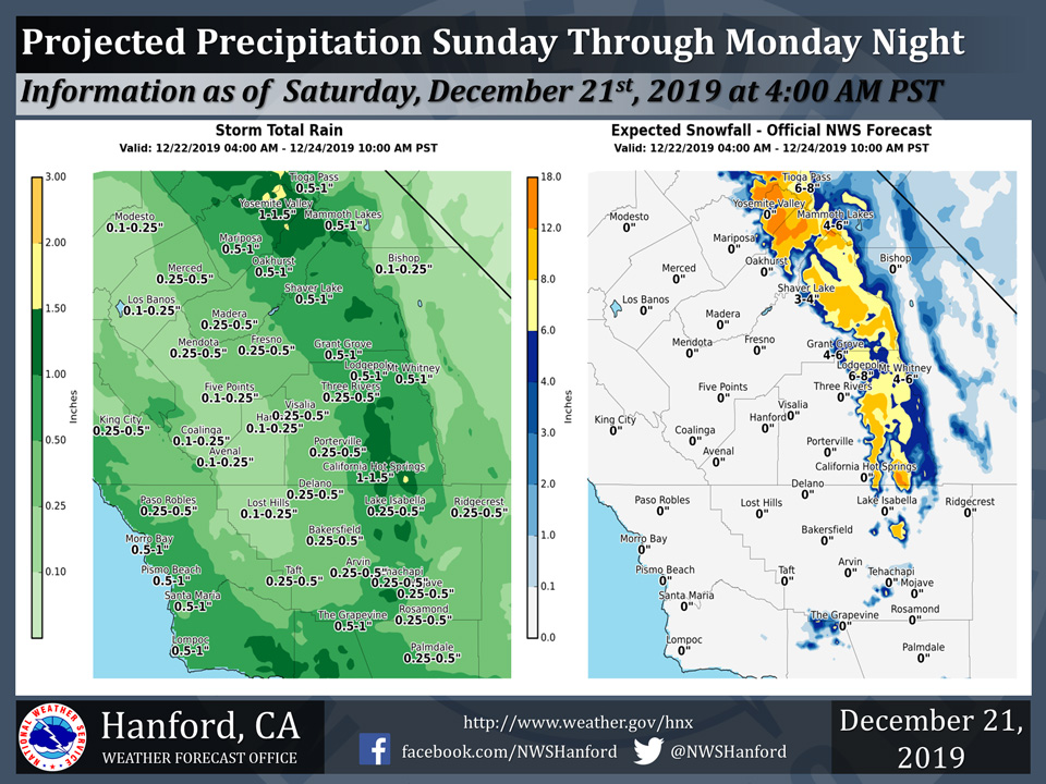
Projected rainfall totals for Mariposa: 0.50" to 1.00"
Projected rainfall totals for Oakhurst: 0.50" to 1.00"
Projected rainfall totals for Yosemite Valley: 1.00" to 1.50"
December 21, 2019 - The National Weather Service Hanford Office reports a storm system will impact Central California Sunday through Monday night.
A Winter Weather Advisory is in effect for the Southern Sierra Nevada above 4,500 feet.
The majority of this precipitation will fall Sunday afternoon and Sunday evening.
  Area Forecast Discussion
  National Weather Service Hanford CA
  425 AM PST Sat Dec 21 2019

  .SYNOPSIS...Dry weather and mild afternoon temperatures can be
  expected over the district today. An increase in clouds tonight
  will be followed by rain and mountain snow Sunday through Monday
  along with colder temperatures. Precipitation will linger over
  the mountains Tuesday while much of the district gets a break
  from wet weather. Another storm will bring a return of rain and
  mountain snow to the region Christmas Day into Thursday.

  &&

  .DISCUSSION...A storm system currently over the eastern Pacific
  will likely disrupt or delay travel for many folks taking to the
  roads or airways this weekend, especially if they wait until
  Sunday to do so. The cold front in advance of this storm system
  will move inland through central California Sunday afternoon and
  evening with its precipitation. As the cold front approaches,
  clouds will gradually thicken over central California through
  tonight. Winds will also increase and peak in intensity through and
  below the mountain passes tonight into Sunday morning as the cold
  front bears down on the CWA. Motorists heading out of the San
  Joaquin Valley may experience wind gusts as high as 45 mph through
  the passes west of I-5 this afternoon through tonight. Southerly
  winds will ramp up at the south end of the San Joaquin Valley and
  over the Kern county mountains by tonight and remain strong until
  the cold front passes through during the midday hours Sunday.
  Winds could gust up to 55 mph at the foot of the Grapevine tonight
  and as high as 70 mph over the summits in the Tehachapi mountains.
  Meanwhile, precipitation accompanying this cold front will fall as
  snow over the higher elevations (above 4500 feet near Yosemite to
  about 5500 feet in Kern county) and rain in the lower elevations.
  Folks heading into the mountains later this weekend should be
  prepared for slick, snow covered roads and potentially long delays
  or road closures. Advisories are in place for strong winds through
  and below the mountain passes and snow over the higher elevations
  of the Sierra this weekend.

  The upper level low associated with this storm system will track
  southward along the California coast Sunday night and Monday and
  bring additional precipitation to the CWA. As the low nears Point
  Conception Monday afternoon and evening, it may bring a healthy
  slug of moisture northward into the mountains of Kern county and
  Tulare county. If so, this will become the focus of heavy precip
  early in the week with the potential for hefty snow accumulations
  above 5,000 feet and a threat of localized flooding in the lower
  elevations. This is something we`ll have to monitor closely Monday
  into Monday night.  The models eject this storm into the Great
  Basin Tuesday as the upper level trough shifts inland from the
  coast. Theoretically this will bring a lull in precipitation over
  much of the CWA on Christmas eve with any residual showers
  confined to the mountains.

  Another round of wet weather is expected Christmas Day into
  Thursday morning as yet another storm system tracks down the
  California coast. Although this second storm does not look as wet
  as its predecessor, it will still bring a renewed threat of wintry
  weather to the mountains during the Christmas holiday with the
  possibility of accumulating snow to elevations as low as 3500 feet.
  This includes the mountain passes in Kern county (i.e. I-5 over
  Tejon Pass and Highway 58 through Tehachapi Pass).

  Toward the end of next week, it appears we`ll finally experience a
  drying trend as our holiday storm exits into the Desert southwest
  and an upper level ridge of high pressure builds into the Golden
  State. Clouds could linger in the upslope regions well into Friday
  while skies become mostly clear elsewhere. If so, this will set
  the stage for night and morning fog in the San Joaquin Valley by
  next weekend with additional travel woes for holiday motorists.

  Temperatures will trend much cooler/colder after today and
  generally average pretty close to normal for much of next week.
  On a final note...the Winter solstice begins at 8:19 pm PST this
  evening.
Source: NWS

