


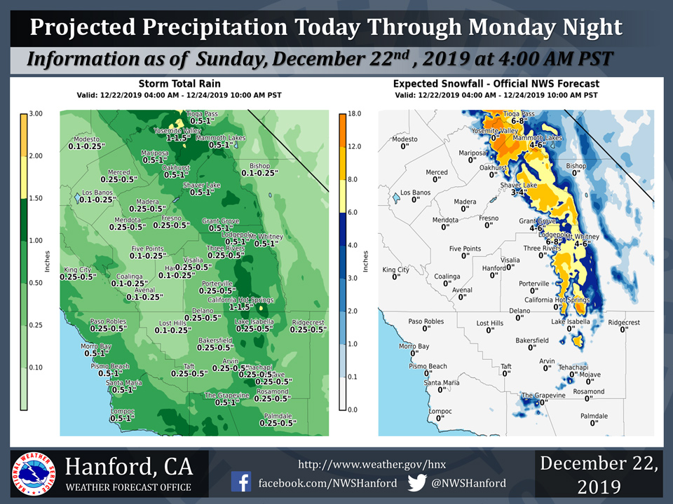
Projected rainfall totals for Mariposa: 0.50" to 1.00"
Projected rainfall totals for Oakhurst: 0.50" to 1.00"
Projected rainfall totals for Yosemite Valley: 1.00" to 1.50"
December 22, 2019 - The National Weather Service Hanford Office reports a storm system will impact Central California today through Monday night.
A Winter Weather Advisory is in effect for the Southern Sierra Nevada above 4,500 feet and for the Fort Tejon area above 5,000 feet, including Frazier Park, Cuddy Valley, and Pine Mountain Club.
The majority of this precipitation will fall this afternoon and evening.
  Area Forecast Discussion
  National Weather Service Hanford CA
  428 AM PST Sun Dec 22 2019


  .SYNOPSIS...Rain and mountain snow will spread across the region
  today through Monday along with colder temperatures and gusty
  southeast winds at times in some locations. Precipitation will
  linger over the mountains Tuesday while much of the area gets a
  break from wet weather. Another storm will bring a return of rain
  and mountain snow to the region Christmas Day into Thursday.

  &&

  .DISCUSSION...
  A frontal system continues to slide slowly south and east toward
  central California. Ahead of this system, southeasterly winds are
  gusting strongly across much of our area. Isolated gusts over 70
  mph have been recorded through the Kern County mountains, while
  numerous gusts over 35 mph have been measured in the extreme south
  end of the SJ Valley as well as the westside hills and adjacent
  Valley terrain. A High Wind Warning remains in effect in the Kern
  County mountains west of Tehachapi as the strong winds are progged
  to continue blowing there through 4 PM this afternoon. The Wind
  Advisory for the Westside Hills also remains in effect through 4
  PM today. Winds are expected to decrease by later this morning in
  the West San Joaquin Valley zone and the Wind Advisory there will
  expire at 10 AM today.

  Models and current radar images suggest the frontal precipitation
  will push into northern portions of our area this morning
  spreading rain and mountain snow southward through the day. Snow
  levels will remain generally at or above 5000 ft and accumulations
  as much as 12 to 15 inches are expected in the southern Sierra
  before the precipitation comes to an end by Monday evening, A
  Winter Weather Advisory remains in effect there through 10 PM
  Monday.

  By the time winds subside in the Kern County Mountains west of the
  Tehachapi area later this afternoon, snow will be accumulating
  generally above 5000 ft. A Winter Weather Advisory is in effect
  there between 4 PM today and 10 PM Monday, as 3 to 7 inches of
  total snow is expected. Before the precipitation ends, as cooler
  air pushes in Monday night, some light snow will be possible near
  pass level at the Grapevine. In addition to the mountain snow,
  rainfall amounts at lower elevations will range from around 1/3 to
  1/2 inch.

  As the trough lifts out by Tuesday, there will be just a few
  lingering mainly light mountain showers ahead of the next
  approaching low pressure system dropping out of the northeast
  Pacific. Models are tracking the main upper level low and the bulk
  of the precip on a southeastward trajectory just off the
  California coast. This will bring less precip to our area, with
  just around a tenth to a quarter inch of rainfall expected
  Wednesday through Thursday as the system passes. Snow levels will
  be lower with this colder system, down as low as 2 to 3 thousand
  feet. Accumulations will however be on the order of just a few
  inches at the higher elevations.

  High pressure will build over the region for the end of the week,
  bringing a return to drier weather. Expect some frosty mornings
  during this time with colder air in place. Conditions can also be
  favorable for development of Valley fog as the ridge builds
  overhead.
Source: NWS

