


California and National Drought Summary for December 24, 2019
Summary
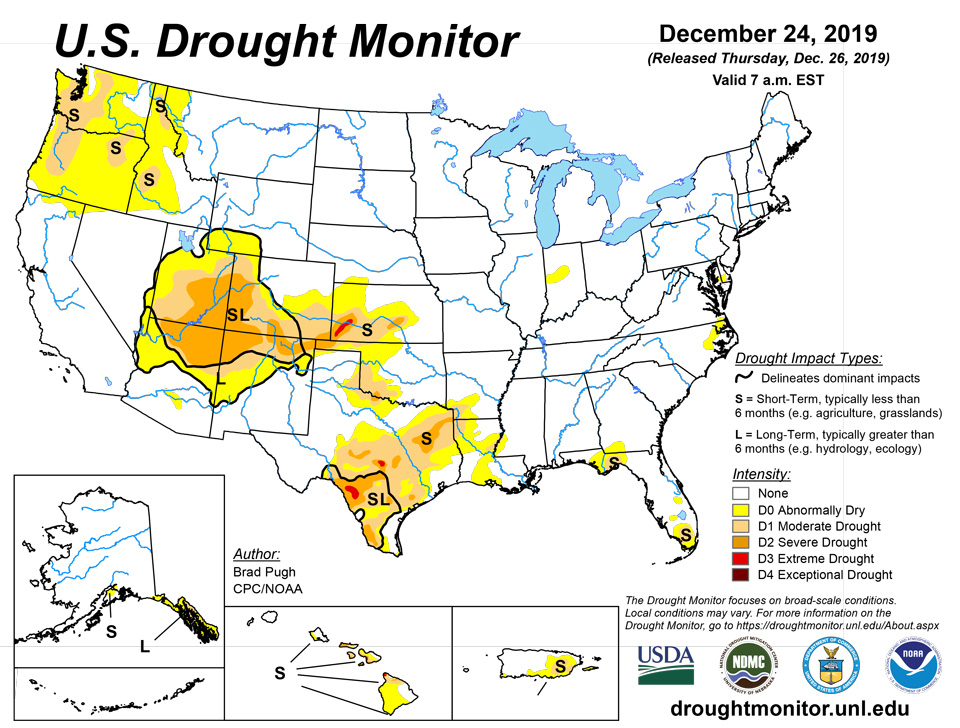
December 26, 2019 - A major pattern change occurred during mid-December as a strong area of upper-level low pressure developed over the northeast Pacific. Following a rather dry November, enhanced onshore flow resulted in heavy rain and high-elevation snow across the Pacific Northwest where 7-day total amounts (liquid equivalent) ranged from 2 to 6 inches, liquid equivalent, or more. Surface low pressure formed over the Gulf of Mexico on December 21 with an eastward track. Widespread heavy rainfall (2 to 6 inches) accompanied this low pressure system from the western Florida Panhandle north to nearly all of Alabama, Georgia, and South Carolina. An expansive area of surface high pressure led to mostly dry weather (December 17 to 23) across the Great Plains, Corn Belt, and Northeast. Mostly dry weather also prevailed across mainland Alaska with periods of precipitation occurring along the Alaska Panhandle. A low pressure system recently developed to the west of the Hawaiian Islands but the heaviest rainfall associated with this low pressure system remained west of Hawaii.
Northeast
Arctic air with mostly dry weather prevailed across this region before temperatures recently moderated. A small area of abnormal dryness (DO) remains designated for parts of southern Delaware and the eastern shore of Maryland based on: 6-month deficits of 4 to 8 inches and 7-, 14-, and 28-day stream flows in the 10-24th percentile. Elsewhere, precipitation averages at or above normal for the 30- to 90-day period.
Southeast
Widespread, heavy rainfall (2 to 6 inches) resulted in the end of lingering abnormal dryness (D0) and moderate drought (D1) across Alabama, Georgia, South Carolina, and the western Florida Panhandle. A 2-category improvement was justified for northern Georgia and the western Florida Panhandle where the heavy rainfall this past week eliminated 60-day precipitation deficits. The recent heavy rainfall caused 7-day stream flows to exceed the 90th percentile in parts of these three states, while the 28-day stream flows have recovered to normal for most locations. Lower 7-day rainfall amounts (an inch or less) were observed across the Florida Big Bend. Based on 90-day percent of normal precipitation, moderate drought (D1) and abnormal dryness (D0) was maintained for the Florida Big Bend extending north to southwest Georgia.
Excessive rainfall triggered flooding in eastern Broward and Miami-Dade counties in south Florida on December 23 with Fort Lauderdale recording 7.13 inches of rainfall. Since the heaviest rainfall occurred along and east of I-95, short-term moderate drought (D1) continues across western areas of Broward and Miami-Dade counties. Abnormal dryness (D0) was reduced across the Florida Peninsula where 1.5 to 3 inches of rain fell during the past week. The current depiction of D0 is based largely on 90-day precipitation deficits.
South
Mostly dry weather prevailed across much of the southern Great Plains during the past week. Therefore, a slight increase in abnormal dryness (D0) and moderate drought (D1) was warranted for southwest Oklahoma and northwest Texas. Also, a small increase in severe drought (D2) was necessary in parts of central Texas, based on 90day SPI values. Soil moisture currently ranks below the lowest 10th or 5th percentile from the Hill Country of Texas southwest to the Rio Grande River which supports areas of severe (D2) to extreme (D3) drought. In contrast to these worsening conditions, a brief period of heavy rainfall (2 to 4 inches) resulted in 1-category improvements in the Brownsville and Corpus Christi areas of Texas.
Midwest
Although mostly dry weather was observed during the past week, this region remains drought-free as 90-day precipitation has averaged at or above normal. USGS 28-day average stream flows continued to be either normal or above normal throughout the region. 30-day precipitation deficits are running 0.5 to more than 1 inch from southeast Iowa and northern Missouri east to northern Indiana and Ohio. A small area of abnormal dryness (D0) was added to parts of central Indiana where 90-day precipitation deficits are 2 to 4 inches and 28-day stream flows have decreased below the 30th percentile.
High Plains
Dry weather prevailed during mid-December from the central Rockies east to the northern and central Great Plains. This is a relatively dry time of year for much of these areas and 90- to 180- day precipitation averages much above normal across the eastern two-thirds of Montana and the Dakotas. However, long-term drought continues to plague western and southern Colorado. Short-term drought of varying intensity persists across southwest and south-central Kansas.
West
Widespread rain and high-elevation snow continued across the Pacific Northwest through December 21 before the storm track shifted south to California. 7-day precipitation amounts (as of 12Z December 23) ranged from 2 to 8 inches, liquid equivalent, or more along and west of the Cascades in western Washington and northwest Oregon. Based on this recent heavy precipitation, an increase in 28-day stream flows above the 25th percentile, and recovery in the 90-day SPIs, abnormal dryness (D0) was reduced slightly in coverage across northwest Washington and coastal Oregon. However, despite the recent heavy precipitation, no changes were made to the remainder of the ongoing abnormal dryness (D0) area given such a dry start to the wet season. Water year to date (since October 1) precipitation deficits of more than 12 inches, 28-day stream flows in the lowest 10th percentile, and basin average snow water content less than 50 percent support the short-term moderate drought (D1) across parts of Oregon and Washington. Heavy precipitation (more than 2 inches, liquid equivalent) during the past week resulted in a slight reduction in moderate drought (D1) in northern Idaho.
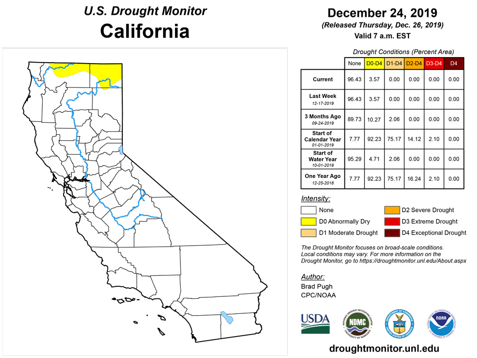
Lighter precipitation (generally less than 2 inches) extended south into northern California this past week, while mostly dry weather prevailed across the remainder of the West. Although basin average snow water content values are above normal across Arizona, New Mexico, and Utah, drought persists in these areas where 180-day precipitation deficits are relatively large and 6-month SPI values support ongoing long-term moderate (D1) to severe (D2) drought.
Alaska, Hawaii, and Puerto Rico
Mostly dry weather prevailed through December 19 across the Kenai Peninsula where a small area of short-term abnormal dryness (D0) continues. The heaviest precipitation (more than 2 inches, liquid equivalent) fell in the southeast Alaska Panhandle, but no changes were made to the long-term abnormal dryness (D0) and moderate drought (D1) coverage.
Heavy rainfall (locally more than 1 inch) lingered through December 17 across southern and eastern areas of Puerto Rico. Despite the rainfall during mid –December, 90-day precipitation deficits exceed 8 inches where short-term drought (D1) is ongoing. Coinciding with this D1 area, 28-day stream flows are mostly between the 11th and 20th percentile.
During the past month, a 1-category improvement in drought conditions has occurred along windward areas of the Hawaiian Islands as rainfall increased. Based on satellite imagery, a low pressure system developed several hundred miles to the west of Hawaii. Although no changes were made this week to the depiction across Hawaii, rainfall associated with this low pressure system will be assessed for next week.
Pacific Islands
A near-equatorial trough persisted for much of this USDM week (12/18/19-12/24/19) across the Republic of Palau, the Federated States of Micronesia (FSM), and the southern Marshall Islands (RMI). A couple weak circulations developed within the trough, with one forming into Tropical Storm Phanfone (30W) over western Yap State and northern Palau later in the week. Showers triggered by convergence associated with the trough were aided by divergent flow aloft over western Micronesia. The band of clouds and rain associated with the near-equatorial trough crossed the equator to form a continuous band with the South Pacific Convergence Zone (SPCZ) which stretched southeastward near and past the Samoan Islands. A tropical disturbance (TD02F / 97P) developed within the SPCZ southeast of Tutuila at mid-week. By the end of the week, the SPCZ moved over the islands with an embedded weak low developing west of Savaii.
Satellite-based estimates of 7-day precipitation (QPE) showed a large area of 4+ inches of rain across much of western Yap State and parts of northern Palau and northern Yap State extending into western Chuuk State. Patchy 4+ inch areas were scattered across eastern FSM and parts of the RMI. The 4+ inch areas were surrounded by 1-4 inch rain areas across Palau, the FSM, and southern to central RMI. Little to no rain was indicated on the satellite QPE across the Marianas to northern RMI. The rain band stretched southeastward across the equator across and past the Samoan Islands. Areas of 4+ inches of rain were seen north, east, and south of American Samoa, with 10+ inches to the east. The QPE indicated 1-2 inches across American Samoa, increasing beyond 2 inches to the east.
In the Republic of Palau, 2.47 inches of rain fell at the Palau International Airport, bringing the monthly total to 9.00 inches. With both the weekly and monthly totals above the minimums needed to meet most water needs, D-Nothing continued at Palau.
In the Marianas, the last 3 weeks have been dry (below the 1-inch weekly minimum) for Guam and Rota and (depending on the observation site) Saipan. Guam had a monthly total of 1.40 inches, which is drier than the previous driest December (2.17 inches in 1992). About a tenth of an inch of rain has been recorded so far this week at Guam (0.16) and Rota (0.14). D-Nothing continued this week because local NWS personnel reported vegetation is still very green for Guam and Rota and topsoil is still moist.
In the FSM, Fananu has been missing for the last couple months and Lukonor was missing 4 days this week, so these two stations could not be analyzed on this draft. Pingelap resumed reporting and had 2.00 inches of rain so far this week. The week was dry at Kosrae (0.90 inch), Kapingamarangi (1.31), Nukuoro (1.90), and Ulithi (1.18 inches with 2 days missing), and wet at Chuuk (2.29) and Pohnpei (3.88). Tropical Storm Phanfone soaked parts of western Yap State, with Woleai reporting 6.08 inches of rain this week and Yap 4.43 inches. With the monthly total (through December 23) at 8.86 inches, which is above the 8-inch monthly minimum, the status was changed from D0-S to D-Nothing at Woleai. D-Nothing continued for the rest of the FSM stations. Kosrae has been very dry for December (7.77 inches through December 24 compared to a normal of about 19 inches), but no drought impacts have been reported.
With the observer off-island, Utirik was missing 5 days this week and could not be analyzed. Mili was wet this week (4.74 inches of rain through the 23rd), while the rest of the RMI stations were dry (less than the 2-inch weekly minimum). Kwajalein reported 0.01 inch of rain this week, a monthly total of 3.47 inches, dry the last 3 consecutive weeks, and little rain received in the last 9 days. Wotje had no rain this week, only 3.32 inches for the month (through December 23), dry the last 3 consecutive weeks, and only 4 days with rain this month. With the last 3 consecutive weeks below the weekly minimum, the status was changed to D0-S at Kwajalein and Wotje. D-Nothing continued at the rest of the RMI stations.
Based on data received so far (through December 23), it was a wet (more than the 1-inch weekly minimum) week at Pago Pago (2.18 inches) and the automated stations at Siufaga Ridge (1.20) and Toa Ridge (1.35). With this and previous weeks and months wet, D0-S continued at Tutuila.
Virgin Islands
The weather conditions across the U.S. Virgin Islands (USVI) during this USDM week (12/18/19-12/24/19) were dominated by dry air and subsidence associated with a high pressure ridge. A short wave trough and surge of moisture triggered scattered showers over the weekend.
Radar-based estimates of rainfall for the 7 days ending at 12z on Tuesday depicted half an inch to an inch of rain over most of the island of St. John and the extreme western tip of St. Croix, and less than half an inch to no rain over St. Thomas and the rest of St. Croix.
Based on data through December 23 or 24, the Henry Rohlsen AP had a third of an inch (0.34) of rain this week, while the Christiansted 1.8 ESE CoCoRaHS station measured 0.79 inch and the Christiansted 4.1 ESE CoCoRaHS station measured 0.67 inch. The station at East Hill reported 0.47 inch for the week and 1.61 inches for the month, or 69% of normal for the month. The Henry Rohlsen AP monthly total of 1.07 inches is 48% of normal. The USGS Adventure 28 well is showing no recovery and is still getting lower; it has fallen about 10 feet since January 2018. In addition to low precipitation, unusually hot temperatures have increased evapotranspiration, further exacerbating drought conditions. The Henry Rohlsen AP reported highs of 88 or 89 degrees on 16 of the first 23 days of December. In addition, daily records have been tied or broken on December 3, 8, 14, 15, 16, 17, 18, 19, and 20. The USDM status for St. Croix continued at D1-SL on this week’s map, but D2-SL may be considered next week if the dryness continues.
Based on data through December 23 or 24, the Cyril E King AP station reported only 0.16 inch of rain for this week, with a month-to-date total of 1.81 inches which is 80% of normal. The year-to-date total is 34.01 inches with a departure of -4.62 inches or 88% of normal. The Anna's Retreat 2.5 ESE CoCoRaHS station reported 0.15 inch of rain for the week. The USGS Grade School 3 well resumed its declining trend, dropping half a foot this week. The USDM status for St. Thomas continued at D0-S this week.
On St. John, the station at Windswept Beach reported 0.26 inch of rain for the week (through December 23) with 4.64 inches for the month so far and 38.60 inches for the year (which is 82% of normal). The USGS Susannaberg well is locally low and resumed its declining trend, falling half a foot this week. The USDM status for St. John continued at D0-S on this week’s map.
Looking Ahead
During the next 5 days (December 26-30), an upper-level low is likely to bring rain and high-elevation snow to southern California and the Southwest. This upper-level low is then likely to spawn a surface low across the southern Great Plains with a subsequent track northeast to the Great Lakes. Beneficial rainfall (0.5 to 1.5 inches) is expected with this low pressure system in southeast Colorado, Kansas, and Oklahoma. Light to moderate precipitation (an inch or less) will overspread the eastern U.S. on December 29 and 30. Following the brief period of heavy precipitation across the Pacific Northwest during mid-December, a drier pattern is likely to end December. Above-normal temperatures are forecast during late December across the central and eastern U.S., while below-normal temperatures prevail across the Great Basin and Southwest. A low pressure system is forecast to move away from the Hawaiian Islands on December 26. Strong onshore flow is likely to result in heavy precipitation (5 to 10 inches, or more) along the Alaska Panhandle. Arctic air with much below-normal temperatures are forecast to affect much of mainland Alaska.
The CPC 6-10 day extended range outlook (December 30, 2019 to January 3, 2020) indicates large probabilities (greater than 80 percent) for below normal temperatures throughout mainland Alaska as anomalous northeast surface flow persists. Wetter-than-normal conditions are forecast to continue into the beginning of January 2020 along the Alaska Panhandle. The strong Pacific flow is likely to prevent the arctic air over Alaska to shift south anytime soon. Therefore, above-normal temperatures are favored for a majority of the continental U.S. Increased chances of below normal precipitation are forecast for California and the Great Basin. Forecast confidence in the precipitation outlook decreases across the central and eastern U.S. with either near or above normal precipitation most likely.
Author(s):
Brad Pugh, NOAA/CPC
Richard Heim, NOAA/NCEI
Dryness Categories
D0 Abnormally Dry—used for areas showing dryness but not yet in drought, or for areas recovering from drought.
Drought Intensity Categories
D1 Moderate Drought
D2 Severe Drought
D3 Extreme Drought
D4 Exceptional Drought
Drought or Dryness Types
S Short-Term, typically less than 6 months (e.g. agricultural, grasslands)
L Long-Term, typically greater than 6 months (e.g. hydrologic, ecologic)
Source: National Drought Mitigation Center

