


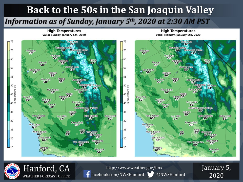
Mariposa projected high temperature for Sunday: 55 degrees and 56 Degrees for Monday
Oakhurst projected high temperature for Sunday: 55 degrees and 58 Degrees for Monday
Yosemite Valley projected high temperature for Sunday: 50 degrees and 54 Degrees for Monday
January 5, 2020 - The National Weather Service Hanford Office reports high temperatures Saturday afternoon in Central California were ten to thirteen degrees above normal for this time of year.
A dry cold front will pass through the forecast area today.
As a result, maximum temperatures this afternoon throughout Central California will generally be seven to ten degrees lower than Saturday afternoon.
Maximum temperatures Monday afternoon will be similar to this afternoon, if not a degree or two lower.
  Area Forecast Discussion
  National Weather Service Hanford CA
  142 AM PST Sun Jan 5 2020


  .SYNOPSIS...Strong gusty winds to the Kern County Mountain Passes
  and Desert expected today. Slight ridging for the first part of
  the next work week before the upper jet gets more active.

  &&

  .DISCUSSION...
  A fairly benign forecast though today will see winds pick up in
  the Kern County mountains and desert as the surface gradient
  tightens. By midday the Bakersfield to Mojave gradient will
  roughly be 5 to 6 mb which will support strong winds. A wind
  advisory is currently in effect for this region.

  Also, enough moisture in the south valley exist for a few very
  light showers on the upslope portions of the San Emigdio and
  Tehachapi Mountains, though not expecting much in the way of
  accumulations. As the aforementioned surface gradient relaxes
  winds will once again flow down valley lessening this potential by
  this evening.

  From there attention is on the long wave trough which is progged
  to dig south across the western CONUS by midweek. The first piece
  of shortwave energy should slide into Central California by
  Wednesday, but impacts will be limited. A secondary shortwave will
  round the trough Thursday which has more potential for impacts
  across the region, though it will be a quick hitter. Yet another
  shortwave trough is progged over the weekend, however, too much
  variations in the guidances with this one to point to how much of
  an impact it might have. Stay Tuned!
Source: NWS

