


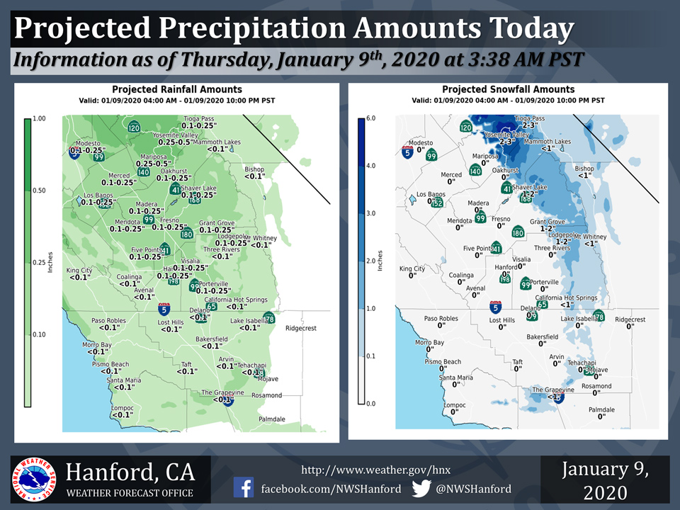
Projected rainfall totals for Mariposa: 0.25" to 0.50"
Projected rainfall totals for Oakhurst: 0.01" to 0.25"
Projected rainfall totals for Yosemite Valley: 0.25" to 0.50"
January 9, 2020 - The National Weather Service Hanford Office reports an atmospheric disturbance will move southward through Central California today.
Precipitation amounts associated with this atmospheric disturbance will be highest from Fresno County northward.
Snow levels will start at 3,500 to 4,000 feet this morning, before rising to 4,500 to 5,000 feet by this afternoon.
  Area Forecast Discussion
  National Weather Service Hanford CA
  435 AM PST Thu Jan 9 2020


  .SYNOPSIS...
  A weak storm system will bring a chance of rain and mountain snow
  to the area today, followed by quiet conditions into the first
  part of the weekend. A series of disturbances will then return
  unsettled weather to the region for next week.

  &&

  .DISCUSSION...
  The next weak shortwave system dropping south out of the northeast
  Pacific is aiming an area of rain and mountain snow toward central
  California. Radar trends and model forecasts suggest the
  precipitation will reach northern portions of our area by 6 AM,
  spreading southward during the day and exiting the region by
  tonight. Qpf with this system is somewhat limited and snow amounts
  in the Sierra zones are expected to be no more than a few inches.
  Snow levels will be low enough to possibly produce a few flurries
  or a light dusting down to pass level in the Kern County mountains
  but major impacts are not expected. Rainfall amounts in the lower
  terrain and San Joaquin Valley should range from a few hundredths
  or a 10th of an inch down south to around 1/4 inch in northern
  portions of the area. Winds accompanying the incoming system will
  gust around 40 to 50 mph through and below the mountain passes in
  Kern County and a wind advisory is in effect there through 7 PM
  this evening.

  Weak shortwave ridging behind the exiting system will bring dry
  weather for Friday with the likelihood of overnight and morning
  fog in the usual places. The next system is then progged to brush
  our area Saturday with a chance for mainly mountain precipitation.
  After a break on Sunday, another weak disturbance will approach or
  area Monday. Model solutions begin to diverge in the details for
  Monday through the middle of next week as a series of
  disturbances impact the western us. Certainty in timing and
  precipitation amounts is low but blended model guidance suggests
  a generally unsettled period with more significant rain and
  mountain snow accumulations. Forecast details will become more
  certain with additional model runs.
Source: NWS

