


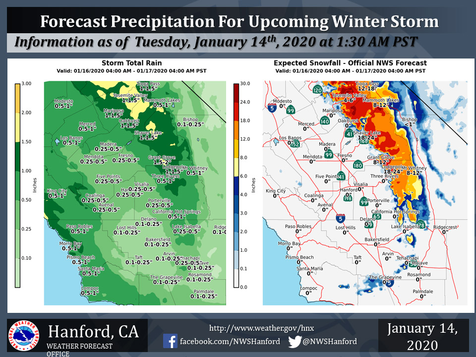
Projected rainfall totals for Mariposa: 1.00" to 1.50"
Projected rainfall totals for Oakhurst: 1.00" to 1.50"
Projected rainfall totals for Yosemite Valley: 1.00" to 1.50"
January 14, 2020 - The National Weather Service Hanford Office reports a possible storm system will bring rain and mountain snow to parts of the Central California Interior from Thursday morning through Friday morning.
Snow will fall generally above 4000 feet with brief periods down to as low as 3500 feet.
The above graphic has the latest projected rain and snowfall amounts.
  Area Forecast Discussion
  National Weather Service Hanford CA
  232 AM PST Tue Jan 14 2020

  .SYNOPSIS...
  A weakening cold front will push through the region today. Near
  freezing temperatures are expected in the San Joaquin Valley
  tonight. A storm system will bring rain and mountain snow to the
  region Thursday into Thursday night. Dry weather will return
  Friday and continue through Martin Luther King Jr day. Another
  system will bring precipitation back to the Sierra on Tuesday.

  &&

  .DISCUSSION...
  A cold front is approaching the region from NORCAL attm.
  Precipitation is very light with the front and will mainly
  impact areas north of Fresno County. Little or no accumulation is
  expected in the Sierra and we are only expecting a few light
  showers and sprinkles north of Fresno county today. We are
  expecting winds to pick up across the Kern county mountains and
  become gusty below the passes into Mojave and through the
  Tehachapi pass. A wind advisory is in effect until 1000 pm PST
  tonight.

  High pressure will build in with a cold air mass moving into the
  area tonight. Temperatures will be around the freezing mark and we
  can expect areas of frost by Wednesday morning. Daytime highs will
  hold steady before a strong system impacts the regoin on Thursday
  and Thursday night. The models have been consistent with this
  feature and confidence is medium because of QPF amounts in the
  CENCAL interior are still a bit uncertain. Snow levels look to be
  aroud 4000 feet with this system with preliminary snow totals up
  to 2 feet from Sierra NF north to Yosemite NP...where some
  isolated amounts of up to 3 feet are possible. Generally 0.25 to
  0.50 inches of rain is possible in the SJV...mainly north of Kern
  county, where 0.10 to 0.25 inches is possible in Kern county. Up
  to 1 inch of rain is possible in the foothills below the snow
  line with this event. These are still preliminary values and may
  change as the event gets closer in time.

  High pressure will build in over the regoin on Friday and
  continue through Monday with the return of fog development in the
  SJV. It will be a nice weekend with seasonal temperatures and
  late night and early morning fog development in the SJV. Guidance
  is advertising another system to begin to impact the region on
  Tuesday and we have added precipitation to the forecast for
  Tuesday in the Sierra.
Source: NWS

