


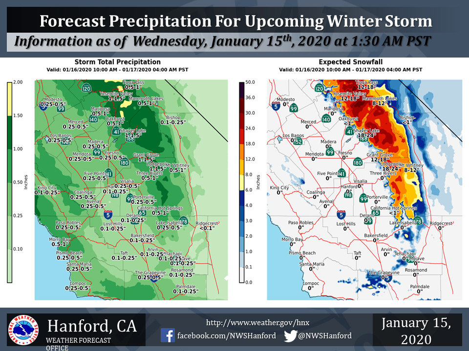
Projected rainfall totals for Mariposa: 0.50" to 1.00"
Projected rainfall totals for Oakhurst: 0.50" to 1.00"
Projected rainfall totals for Yosemite Valley: 1.00" to 1.50"
January 15, 2020 - The National Weather Service Hanford Office reports a storm system will bring rain and mountain snow to parts of the Central California Interior from late Thursday morning through early Friday morning.
Snow will fall generally above 4000 feet with brief periods down to as low as 3500 feet.
The above graphic has the latest projected rain and snowfall amounts.
  Area Forecast Discussion
  National Weather Service Hanford CA
  324 AM PST Wed Jan 15 2020


  .SYNOPSIS...
  Near freezing temperatures are expected in the San Joaquin Valley
  tonight. The next storm system will be responsible for mountain
  snow and valley rain Thursday afternoon and Thursday night. Dry
  weather will return to Central California Friday and persist
  through Monday. Another weather system will move through Tuesday
  and Wednesday bringing mountain snow.

  &&

  .DISCUSSION...
  High pressure will build in over the region today with upslope
  clouds along west and north facing slopes of the Sierra and Kern
  county mountains. After a chilly start this morning we will see
  seasonal temperatures today across CENCAL. Clouds will increase
  across the area in advance of an approaching cold front that is
  associated with a "bombogensis" system off the WA/OR coast. Decent
  moisture is associated with the front but it is not a true AR
  event due to lack of deep tropical moisture. This will be a cold
  system and snow levels will be around 4000 feet.

  Low pressure has dropped from 1010mb low around 00z Wed to around
  988mb by 12z Wed. That is around 22mb in 12 hours! The storm will
  drift north off the WA coast by this afternoon and is expected to
  drop another 13mb to around 975mb by 00z Thursday. PAC NW will get
  hit hard with this storm. The front will push through on Thursday
  and Thursday night. Heavy snow...up to 2 feet with a few isolated
  amounts up to 3 feet in the high county is expected. Much needed
  rain is forecast in the SJV...manly in the afternoon on Thursday.
  Most areas in the SJV will see 0.25 to 0.50 inches of rain with
  the frontal passage. South valley will see lesser amounts of 0.10
  to 0.25 inches.

  Rain will change over to snow behind the front as cold air moves
  into the foothills. Snow levels will drop to around 3500 feet
  behind the front and we could see some light snow in the Oakhurst
  area in the foothills. Another concern is that we will be
  monitoring is the potential for accumulating snow on the I-5
  Grapevine pass and the SR58 highway through the Kern county
  mountains late Thursday night and into Friday morning. Current
  forecast snow amounts are 2 to 4 inches above 5000 feet...however
  we may see an inch or two down to pass level.

  Once the front moves through on Friday morning, we are expecting
  some residual upslope clouds along the Sierra foothills and north
  facing slopes of the Kern county mountains on Friday. Some light
  precip is still possible in the Kern county mountains as upslope
  forcing could be enough to keep the precip going on Friday
  morning. Cold ridge of high pressure will build in over the region
  for the holiday weekend with temperatures slightly below normal
  for this time of year. Patchy fog is possible each night this
  weekend with good radiational cooling conditions expected.

  Another cold front is forecast to move in just north of the
  forecast area on Monday and could produce a few snow showers in
  the Sierra. The front will weaken as it moves south early on
  Tuesday morning. Light precip is possible on Tuesday mainly north
  of Kings and Tulare counties...however confidence is not very high
  with the timing of the cold front. By Wednesday we are looking at
  the front dissipating and high pressure taking over. The GFS and
  ECM are not in very good agreement with the extended beyond
  Monday.
Source: NWS

