


California and National Drought Summary for January 14, 2020
Summary
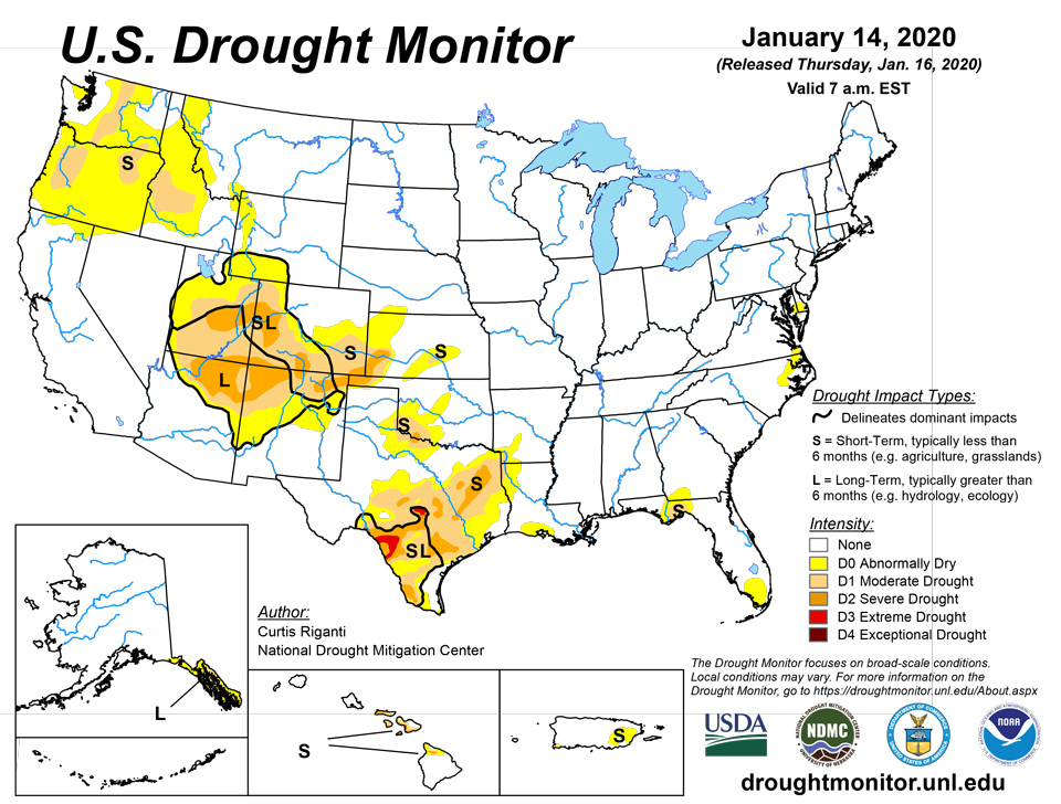
January 16, 2020 - Warmer than normal temperatures were common this week over the eastern half of the continental U.S., while temperatures were primarily near normal over the western half, with a few exceptions. Moderate to heavy precipitation was common this week along and east of the Interstate 35 corridor, excepting parts of the Northeast and the Florida Peninsula. In the West, moderate to heavy precipitation also fell in some of the higher elevation areas. For more details on the geographic distribution of precipitation and temperature anomalies, please see the regional paragraphs below. The only exceptional drought occurring in the United States, on Maui, was removed this week after a major precipitation event in Hawaii, where other improvements were also made. Heavy rainfall in northern and eastern Puerto Rico also ended the moderate drought there. In the central and eastern continental U.S., drought conditions generally improved in areas that received heavier precipitation, while some degradation occurred in locations in Texas and Oklahoma that remained drier. The depiction of moderate drought and abnormal dryness also changed in Idaho, Washington, and Oregon, where recent precipitation (or lack thereof) affected mountain snowpack and short-term precipitation deficits. For more details on changes made to the drought depiction, please see the regional paragraphs.
Southeast
Widespread precipitation fell in the Southeast region over the past week, with the exceptions of the eastern Florida Panhandle and the Florida Peninsula. Precipitation amounts ranged from about a half inch to as much as 2-3 inches across most areas that received precipitation. Temperatures were warmer than normal this week. The warmest areas were parts of Alabama, Georgia, South Carolina, and North Carolina, where temperatures soared to 9 to 12 degrees above normal in some locations. Due to the widespread rainfall, drought-free conditions continued in Alabama and South Carolina.
Midwest
Across the southern portion of the region (roughly the southeastern halves of Iowa and Wisconsin to the southeast), widespread precipitation of at least a half inch fell this week. The heaviest amounts fell from central and southern Missouri through southern portions of Illinois and Indiana, where precipitation amounts ranging from 2 to locally as high as 5 inches were common. Warmer than normal temperatures covered most of the region, particularly in Ohio and Kentucky and southern Indiana, where some locations were at least 15 degrees warmer than normal for the week. In contrast, northern Minnesota was 5 to 10 degrees below normal. Abnormal dryness ceased in western Indiana, where over 2 inches of rain fell. Elsewhere across the region, freedom from drought and abnormally dry conditions persisted.
Northeast
Precipitation over one-half inch fell in spots in the Northeast. The wettest areas (where precipitation ranging from 1-2 inches occurred) were found from Lake Ontario to northern Maine, generally near the Canadian border. Warmer than normal temperatures took place in the Northeast this week. Most areas, aside from central Pennsylvania and Maine, were 10 to 15 degrees warmer than normal for the week. Short-term dryness continued in Delaware this week, where streamflow and soil moisture were lower than normal. Aside from this area of abnormal dryness, the rest of the Northeast avoided abnormal dryness and drought for another week.
South
Most of the South had warmer than normal temperatures this week, though widespread rainfall led to reduction in drought conditions in parts of the region. Temperatures ranged from 10 to 15 degrees warmer than normal in Mississippi and Tennessee to generally 5 to 10 degrees above normal in Oklahoma and Texas. Excluding south Texas, moderate to heavy rain fell across the portion of the region to the east of the Interstate 35 corridor. The highest rain amounts, with some locations exceeding 3 inches, fell upon north-central Texas, southeast Oklahoma, Arkansas, far northeast Louisiana, and northern Mississippi. The heavy rain in east Texas and adjacent portions of Louisiana, Arkansas, and southeast Oklahoma led to improvement in drought and abnormally dry conditions in these areas, where short-term precipitation shortages were lessened, and streamflow improved. In areas west of the more widespread precipitation in Texas and Oklahoma, some of the drought and abnormally dry areas were expanded where short-term precipitation deficits grew.
High Plains
Across the High Plains region, primarily dry and near normal or cooler than normal conditions occurred, with the exceptions of south-central and eastern Kansas, where warmer than normal temperatures occurred and over a half inch of precipitation fell. Temperatures mostly ranged from 5 to 10 degrees cooler than normal in South Dakota and North Dakota this week. Moderate and severe drought continued in south-central and southwest Kansas, respectively, and no changes were made to the drought or dryness depiction in the region.
West
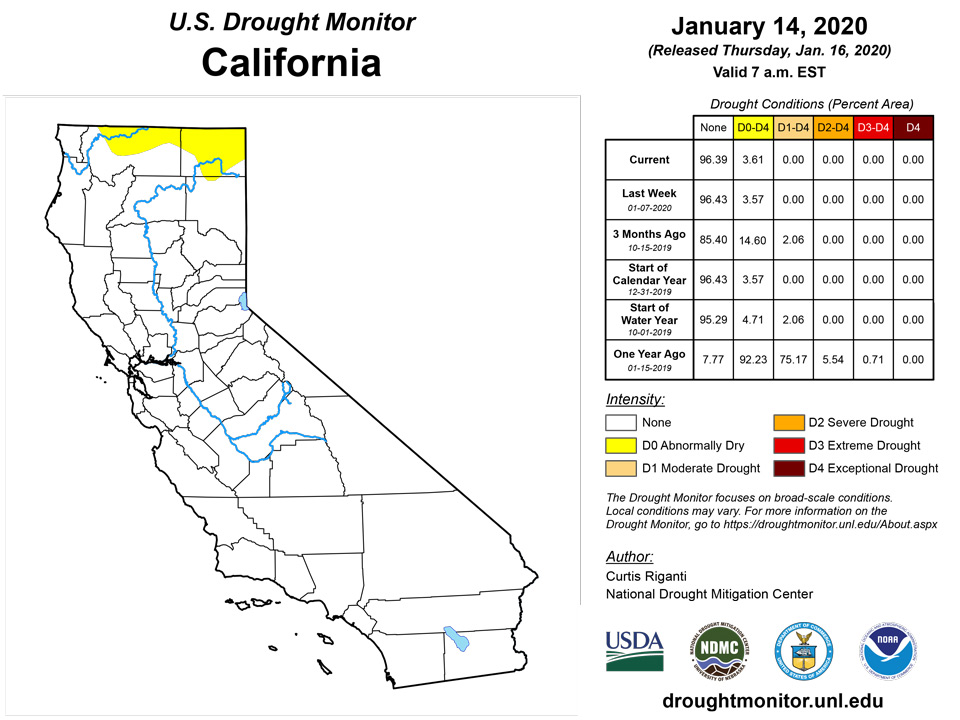
Temperatures varied across the West region over the past week. Eastern Utah and north-central Montana had temperatures 5 to 15 degrees cooler than normal, while western Utah was 5 to 10 degrees warmer than normal. Warmer temperatures continued in the eastern and southeastern plains of New Mexico, and abnormally dry conditions were expanded where high evaporative demand combined with lower recent precipitation amounts. Heavy mountain snow occurred in the Cascades, where abnormal dryness and moderate drought slightly improved as short-term precipitation deficits slightly lessened and snowpack grew. High elevation areas of Colorado, Wyoming, Idaho, Montana, northern Utah, and northern California received precipitation this week, while lower elevation locations generally stayed dry. Moderate drought and abnormally dry conditions shifted in Idaho in response to changing snowpack and precipitation deficits over the past week.
Alaska, Hawaii, and Puerto Rico
Heavy rain over the past week in northern and eastern Puerto Rico improved precipitation deficits and streamflow enough to end the moderate drought that had been going on, though abnormal short-term dryness remains in spots. Short-term precipitation in the Alaska Panhandle has been near or above normal, but long-term precipitation deficits remain in the area, so long-term drought and abnormal dryness continued another week. Very low snowpack was noted on the Kenai Peninsula, though sufficient precipitation was occurring to keep abnormal dryness at bay. In Hawaii, a major rainfall event drenched parts of the state, leading to widespread improvements in drought conditions this week. Exceptional drought on Maui ceased, severe drought was improved to moderate drought in northeastern Kaho’olawe, and the abnormal dryness on Oahu abated. On the Big Island, the abnormal dryness in the southern half of the island was removed, severe drought in northwestern reaches of the island improved to moderate drought, and moderate drought on the northern half of the island was mostly eliminated, save the aforementioned severe drought area and a remaining area of severe drought around Waimea.
Pacific Islands
During the Northern Hemisphere winter, the North Pacific subtropical high, and the low latitude Inter-Tropical Convergence Zone (ITCZ), migrate south toward the equator. The seasonal migration brings drier subtropical trade winds to the northern portions of Micronesia and ITCZ rainfall to the southern regions. The weather conditions across the U.S.-Affiliated Pacific Islands (USAPI) during this USDM week (1/8/20-1/14/20) reflected this seasonal pattern.
A weak circulation developed during the week near Koror, Republic of Palau, before drifting to the west and north. Most of the shower activity associated with this disturbance remained to the north of Palau. Parts of western Micronesia continue to be monitored for further development or intensification of short-term dryness. Closer to the equator, ITCZ-related showers soaked some islands, including Nukuoro. Across the Marianas, minor disturbances embedded in the northeast trades produced a few showers—but did not result in enough rain to ease dry conditions. On Guam, the Keetch-Byram Drought Index (KBDI)—indicative of fire danger—stood at 593 (on a scale of 0 to 800) at the end of the drought-monitoring period, down slightly from an earlier peak over 600. According to the National Weather Service, “vegetation [on Guam] is now starting to get stressed. The grass in the lawn here is turning yellow.”
In the Republic of Palau, short-term dryness continued to develop. During the first 14 days of January, the National Weather Service office (WSO Koror) received rainfall totaling just 0.97 inch. That observation site also ended 2019 on a dry note, with 0.39 inch reported from December 20-31. Based on that data, as well as reports of short-term rainfall deficits elsewhere in the Republic of Palau, abnormal dryness (D0-S) was introduced.
In the Marianas, drier-than-normal weather persisted on most islands. At the international airport on Guam, record-low December rainfall was followed by a total of 0.88 inch (36 percent of normal) during the first 14 days of January. Rota received 1.10 inches during the weekly drought-monitoring period—but reported less than two-thirds of an inch in each of the 5 preceding weeks. Saipan has received less than an inch of rain for 7 consecutive weeks. A few spots in the Marianas fared better in recent days—for example, Agat reported 1.95 inches of rain from January 10-12—but abnormally dry conditions (D0-S) were retained for Guam and Rota and added to Saipan.
In the FSM, abnormal dryness (D0-S) was removed from Kapingamarangi, following a period of significant rainfall during the first half of January. Specifically, Kapingamarangi received 3.93 inches of rain from January 1-14, with one day missing. Much of the rain, 3.12 inches, fell from January 6-10. Meanwhile, a few spots in the FSM received heavy rain, with Nukuoro reporting 4.00 inches on January 13-14. Similarly, Ulithi endured a 6.98-inch deluge on January 10. In contrast, parts of Yap State have trended dry in recent weeks and will continue to be monitored for the need to introduce abnormal dryness. In addition, Lukunor received rainfall totaling only 0.03 inch during the drought-monitoring period—but this follows near-normal December rainfall, when 10.23 inches fell. Insufficient rainfall data is available to provide an analysis for Fananu.
In the Republic of the Marshall Islands, abnormal dryness (D0-S) was removed from Majuro, despite lingering low reservoir storage. Majuro received 4.03 inches of rain from January 8-11, boosting reservoir storage from 22.9 to 26.8 million gallons (from 64 to 74 percent of capacity). Though storage below 80 percent of capacity is indicative of drought concerns, the recent downpours on Majuro have eased those issues. Elsewhere in the RMI, there is neither dryness nor drought, except on Utirik. Recently updated data for Utirik indicates that rainfall has totaled less than an inch for 4 consecutive weeks, allowing abnormal dryness (D0-S) to develop. Weekly (January 8-14) rainfall totals were less than an inch on several islands, including Kwajalein (0.65 inch), but earlier wetness precludes the need to introduce dryness for those locations.
American Samoa remains wet, following a December rainfall total of 17.93 inches at the international airport. During the first 14 days of January, rainfall at the airport reached 4.41 inches.
Virgin Islands
The U.S. Virgin Islands (USVI) have entered the traditional winter dry season, but almost daily showers have been observed in recent weeks. The latest drought-monitoring period (January 8-14) was no exception, as frequent showers continued to provide relief in the wake of a drier-than-normal autumn wet season.
On St. Croix, January 1-14 rainfall at Rohlsen Airport totaled 1.94 inches (187 percent of normal). Standardized Precipitation Index (SPI) data indicated that short-term rainfall deficits have been eradicated, but longer-term impacts remain. For example, the USGS Adventure 28 well has begun to slightly respond, but the depth to water remains more than 4 feet lower than the beginning of 2019. Moderate drought (D1) persisted on St. Croix, but the designation was changed from “SL” to “L” to reflect long-term effects on groundwater.
Showery weather also continued across St. Thomas and St. John, where neither dryness nor drought was indicated. A CoCoRaHS observer near Anna’s Retreat on St. Thomas reported a month-to-date rainfall of 2.75 inches through daybreak on January 14. Meanwhile, a volunteer observer at Windswept Beach on St. John received a month-to-date total of 2.01 inches through sunset on January 13. USGS wells on both islands continued to respond to the winter rainfall.
Looking Ahead
Another winter storm system is forecast to traverse the Central Plains, Midwest, and eastern continental U.S. from Thursday, January 16 into the weekend of Saturday the 18th, delivering widespread rain, snow, and a mix of winter precipitation types. For January 16-21, the National Weather Service Weather Prediction Center is forecasting over three-quarters of an inch of precipitation in a widespread area from coastal central and northern California northward through the high elevation areas of western Washington and Oregon. Precipitation is also forecast in the central and northern Sierra Nevada, and in some of the high elevation regions of the Rocky Mountain Front Ranges and Intermountain West. Widespread precipitation is forecast from West Texas northeastward along and north of the Interstates 44 and 70 corridors and in the Ohio Valley and Northeast, where amounts may exceed an inch in some areas. Temperatures will vary in the High Plains and West during this period, while generally warmer than normal conditions over the eastern continental U.S during the first half of the weekend are forecast to be replaced by colder than normal weather afterward. For January 21-25, the National Weather Service Climate Prediction Center is forecasting mainly warmer than normal temperatures from the High Plains westward, and below-normal temperatures in the South, Southeast, and Northeast. Below-normal precipitation is favored during this period in the Northeast, Great Lakes and Ohio Valley, while above-normal precipitation is favored in the Pacific Northwest, the Central and Southern Great Plains, and areas in between.
Author(s):
Curtis Riganti, National Drought Mitigation Center
Brad Rippey, U.S. Department of Agriculture
Dryness Categories
D0 Abnormally Dry—used for areas showing dryness but not yet in drought, or for areas recovering from drought.
Drought Intensity Categories
D1 Moderate Drought
D2 Severe Drought
D3 Extreme Drought
D4 Exceptional Drought
Drought or Dryness Types
S Short-Term, typically less than 6 months (e.g. agricultural, grasslands)
L Long-Term, typically greater than 6 months (e.g. hydrologic, ecologic)
Source: National Drought Mitigation Center

