


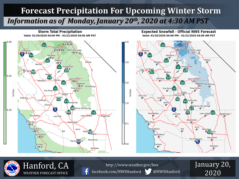
Projected rainfall and snowfall totals for Mariposa County and Eastern Madera County.
January 20, 2020 - The National Weather Service Hanford Office reports a weak storm system will bring light rain and light mountain snows to parts of the Central California Interior from late today through late Tuesday night.
Snow will fall generally above 5000 feet.
Here are the latest projected rain and snowfall amounts.
  Area Forecast Discussion
  National Weather Service Hanford CA
  150 AM PST Mon Jan 20 2020


  .SYNOPSIS...
  Slight chance of precip in the Sierra Nevada today and tomorrow as
  a disturbance passes to our north. Dry weather through the rest of
  the work week as a ridge of high pressure builds, which will also
  be conducive to morning fog in the valley. Next chance of precip
  may occur later this weekend.

  &&

  .DISCUSSION...
  Latest GOES 17 satellite IR imagery reveals high clouds
  progressing over the district early this morning. Currently
  expecting morning lows to be around 39-42 degrees across most of
  the San Joaquin Valley. Some mixing may occur this morning ahead
  of the disturbance to our north, potentially preventing
  widespread fog across the Valley. Precipitation is possible in the
  Sierra Nevada this afternoon through tomorrow afternoon for
  Fresno County and northward, but model guidance is showing QPF
  totals to be scant as the main precip will be further north,
  associated with the upper low. Gradients in Kern County may
  tighten up by Tuesday afternoon through Wednesday morning to
  generate gusty winds in the Kern County mountain passes and Mojave
  Desert.

  Wednesday, models are in agreement that a ridge of high pressure
  will begin to build over Central California. This will lead to a
  period of dry weather with morning bouts of fog likely across the
  Central Valley. Upper ridge will begin to weaken by the end of the
  work week as an upper trough approaches the west coast. Blended
  model guidance is showing a chance of precip for the forecast area
  by Sunday as the trough nears, however the location and timing of
  the trough this far out is somewhat unclear. Either way, it will
  likely break up the stagnant weather pattern that is forecast to
  occur for the latter portion of this work week. Details regarding
  this system will be ironed out with additional model guidance.
Source: NWS

