


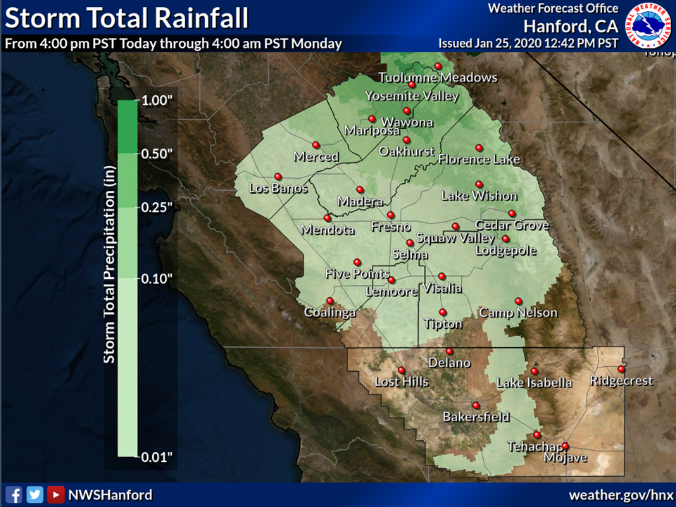
Projected rainfall totals for Mariposa: 0.25" to 0.50"
Projected rainfall totals for Oakhurst: 0.25" to 0.50"
Projected rainfall totals for Yosemite Valley: 0.50" to 1.00"
January 25, 2020 - The National Weather Service Hanford Office reports a cold front will push through the CENCAL interior starting late tonight and continuing through Sunday night.
Precipitation will be light with this system as it moves through.
Rainfall will be generally light and limited to mainly North of Kern County.
Up to one tenth of an inch is possible in the SJV and up to a half an inch is possible in the Sierra Foothills.
  Area Forecast Discussion
  National Weather Service Hanford CA
  250 PM PST Sat Jan 25 2020


  .SYNOPSIS...
  Seasonably mild conditions can be expected today, then rain and
  mountain snow likely overnight into Sunday morning, mainly from
  Fresno County northward. Isolated thunderstorm are possible
  during the late morning and afternoon on Sunday, mainly in
  Mariposa and Madera Counties. Dry weather then returns as another
  ridge of high pressure builds over the region on Monday and
  Tuesday with mornign fog possible both mornings.

  &&

  .DISCUSSION...
  Fog has quickly dissipated across the area this morning giving way
  to a warm Saturday afternoon across the Southern San Joaquin
  valley and Kern County desert. Upper level ridge remains on place
  over the area. There is some persistent low level cloud cover
  along the eastern half of the valley, as well as increasing mid
  to upper level clouds associated with the approaching system. With
  the persistent clouds, afternoon high temperatures will remain in
  the low 60s in the valley and mid to upper 60s in the Kern County
  desert.

  Models are still consistent bringing the upper level trough and
  its associated cold front into the central California interior
  overnight into early Sunday morning. Precipitation will move into
  the northern half of the district by midnight/early morning before
  spreading southward across the district by early Sunday
  afternoon. As with prior model solutions, a majority of the
  energy and precipitation with this system will pass to our north.
  Thus, QPF amounts within the valley will be less than a tenth of
  an inch primarily north of Kern County. Between a tenth and a
  quarter of an inch will be possible in the central Sierra
  foothills and up to a half an inch of QPF is possible in the
  Yosemite Park area. Generally less than a tenth of an inch is
  possible toward the Tulare County and Tehachapi mountains. No
  precipitation is expected in the Bakersfield area nor the Kern
  County desert. Snow amounts of three to six inches is likely in
  the Yosemite area southward into far northern Tulare County. Snow
  levels will begin around 8,000 feet tonight, before falling to
  around 6500 feet by Sunday afternoon as the cold core of the
  trough pushes through the area. In addition, as the trough moves
  through the northern half of the district, isolated post-frontal
  thunderstorms are possible, mainly in Mariposa and Madera
  Counties.

  The aforementioned trough moves eastward out of the area by
  Sunday afternoon. High-resolution models indicate an increasing
  LAS-SFO pressure gradient to roughly 10mb. As such, strong
  northwesterly winds will be possible in the Kern County mountains
  late Sunday morning into Monday morning. Wind gusts up to 45 to 55
  mph are likely, mainly through and below the Kern County mountain
  passes. A wind advisory has been issued from 10 AM PST Sunday
  morning through 4 AM PST Monday morning.

  Upper level ridge will setup across the area on Monday into
  early Tuesday and patchy fog may become possible in the valley
  both mornings. Longer-term models still advertise a weak upper
  level trough moving slightly north of our area late Tuesday into
  Wednesday, but no precipitation is expected anywhere across the
  district. This feature may be enough to mix the lower atmosphere
  and prevent for formation on Wednesday morning. Moving on from
  Thursday into the end of the forecast period next Saturday,
  longer-term models in decent agreement building a strong 588
  decameter high pressure across the region. Temperatures during
  this time frame will increase to above average, with upper 60s to
  low 70s across the valley and Kern County desert by the end of
  next week. It looks like after the chance of rain on Sunday,
  conditions for the remainder of the month appear to remain dry.
  Morning fog may also be possible those mornings in the valley.
Source: NWS

