


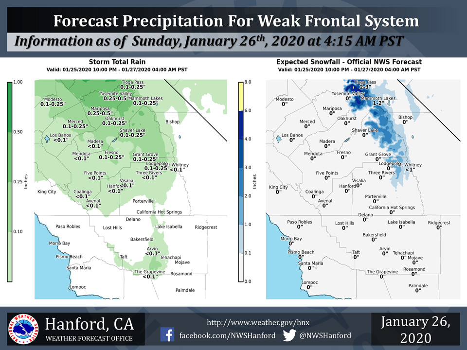
Projected rainfall totals for Mariposa: 0.25" to 0.50"
Projected rainfall totals for Oakhurst: 0.10" to 0.25"
Projected rainfall totals for Yosemite Valley: 0.25" to 0.50"
January 26, 2020 - The National Weather Service Hanford Office reports the cold front moving into central CA. this morning will bring some mainly light precipitation as it pushes south through tonight.
Snow will be confined to mainly above 7000 feet. Here are the latest projected rain and snowfall amounts.
  Area Forecast Discussion
  National Weather Service Hanford CA
  344 AM PST Sun Jan 26 2020

  .SYNOPSIS...A cold front will bring showers into parts of
  the central California interior today into tonight along
  with gusty winds through and below the Kern county mountain
  passes. Dry weather can be expected Monday through Friday
  with areas of night and morning low clouds and fog in the
  San Joaquin Valley. Temperatures will average close to
  normal through Tuesday. Springlike afternoon temperatures
  can be expected later in the week through next weekend.

  &&

  .DISCUSSION...A Winter morning without dense fog in the San
  Joaquin Valley is a good one, and so is the case early this
  morning, thanks to a cold front that is approaching from the
  northwest. The cold front shows up pretty well on the latest
  satellite imagery and is defined by a narrow band of showers
  which is currently moving through the San Francisco Bay area.
  Well in advance of this system, radar is currently showing a
  speckling of light showers from Fresno county northward.

  It`s been 10 days since a storm system brought wet weather
  into the central California interior. Unfortunately this will
  be the last system to do so for at least the next 6 to 10 days.
  Nonetheless, the cold front that breezes through the CWA this
  afternoon will be accompanied and followed by some showers,
  mainly over the eastern half of the San Joaquin Valley as well
  as the foothills and mountains. Precipitation amounts will be
  rather light with this feature. How light? Trace amounts to
  several hundredths on the west side and in the south valley
  to about a quarter of an inch on the valley`s east side and
  adjacent foothills from Fresno county northward. The higher
  elevations of the Sierra can expect a tenth to a third of an
  inch with local amounts of up to a half inch. Snow levels
  will start out around 8,000 feet then lower to about 6,000
  feet by this evening with accumulations of 2 to 5 inches in
  the Sierra, mainly north of Kings Canyon.

  The upper level trough associated with this system is shallow,
  the dynamics are weak, and the upper boundary layers are not all
  that cold this far south to support instability thunderstorms
  this afternoon. In collaboration with neighboring WFO`s and SPC,
  we`ve decided to pull thunderstorms out of the forecast for today.
  In the wake of the surface cold front, west winds will increase
  below the Kern county mountain passes this afternoon and continue
  into early this evening. Local wind gusts of up to 55 mph could
  occur in the normally wind prone areas right below the passes.
  The high resolution models forecast the strongest winds in this
  region to occur primarily between 2 pm and 9 pm. Otherwise, these
  downsloping winds will keep the Kern county desert dry.

  Although the cold front will be well south and east of our CWA
  tonight, a few showers may linger along the valley facing slopes
  of the Tehachapi mountains into the predawn hours Monday. Low
  stratus will otherwise blanket the west facing slopes of the
  Sierra and probably the south end and much of the east side of
  the San Joaquin Valley tonight into Monday morning. Hopefully the
  atmosphere will remain well mixed to mitigate dense fog formation
  over the remainder of the San Joaquin Valley later tonight into
  Monday morning. Otherwise, Monday will turn out pretty nice with
  seasonable afternoon temperatures and a good deal of sunshine in
  most areas, thanks to short wave ridging aloft. Fog could develop
  in the San Joaquin Valley where skies clear Monday night and
  persist into Tuesday morning.

  The ridge aloft will flatten over central California Tuesday as
  a weak upper level trough treks through the Pacific Northwest.
  Precipitation from this system will likely remain north of our
  CWA Tuesday. As this trough dives into the Great Basin Tuesday
  evening, it will produce a northerly flow aloft in its wake over
  California. If so, it might provide enough atmospheric mixing to
  keep fog development to a minimum in the San Joaquin Valley
  Tuesday night. (no promises)

  Night and morning fog in the valley will become more prolific
  later this week through next weekend as a strong upper level
  ridge of high pressure over the eastern Pacific builds into
  California. Dense fog in the San Joaquin Valley could become
  fairly widespread each night by then and certainly slow travel
  for morning commuters. Outside of the San Joaquin Valley, the
  weather will be nice and sunny in the 5 to 7 day period with
  springlike afternoon temperatures. Thermometer readings could
  jump into the 70s in the foothill and desert regions each
  afternoon from Friday through Groundhog Day.
Source: NWS

