


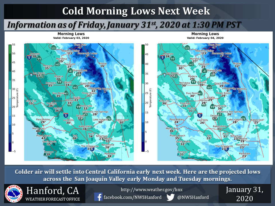
Mariposa, Oakhurst and Yosemite Valley Low Temps in the 20's!
February 1, 2020 - The National Weather Service Hanford Office reports a cooler air mass settling into central California after Sunday’s storm will introduce much colder morning low temperatures for Central California.
Areas of frost can be expected over much of the San Joaquin Valley early Monday, Tuesday, and Wednesday morning as lows may dip near or below freezing, especially on Tuesday and Wednesday.
  Area Forecast Discussion
  National Weather Service Hanford CA
  348 AM PST Sat Feb 1 2020


  .SYNOPSIS...
  Dry conditions and above normal temperatures through Saturday. A
  Pacific storm brings windy and much cooler conditions Sunday.
  Light precipitation is expected Sunday afternoon and night,
  mainly over the foothills and mountains. Dry conditions expected
  throughout much of next week.

  &&

  .DISCUSSION...
  Patchy fog forming in parts of the San Joaquin Valley this
  morning. Satellite images show the thicker fog along the low lying
  areas of the San Joaquin and King Rivers. A ridge of high
  pressure will continue to dominate central CA today with above
  normal temperatures and dry conditions. Maximum temperatures are
  forecast to be around 8-12 degrees above normal. Think some patchy
  fog will form again tonight with favorable radiational cooling
  conditions before the next weather system. Any fog in the valley
  should lift into low stratus Sunday morning with a stronger
  onshore flow and wind mixing.

  The next weather system moving through central CA Sunday is a
  positive tilted upper trough moving onshore through north CA. The
  system will be cold but be limited with moisture. The trough will
  move east into the Great Basin on Sunday night. The system will
  be a fast moving and moisture starved, so precipitation will be
  mainly light and mostly confined to the mountains. Rainfall
  amounts are only 0.1" to 0.2" liquid in the Sierra which
  translates to 1-3 inches of snowfall. While snow amounts will be
  light, there is potential for some winter hazards in the Kern
  County Mountains late Sunday night as snow levels will lower to
  pass levels.

  The more significant impact from this system will likely be from
  strong gusty winds. Onshore wind flow will be on the increase by
  mid-day Sunday as the surface pressure gradient ramps up. A Wind
  Advisory has been issued for the West Side Hills and most of the
  SJ Valley from Noon to 10 PM Sunday. Upper level winds near 90kts
  turn NW behind the trough Sunday evening. The wind direction will
  be cross mountain flow over the Tehachapis, thus high winds will
  possible especially below the mountain passes Sunday evening in
  parts of the Kern County Mountains and Desert. A High Wind Watch
  has been issued for this area from Sunday afternoon through Monday
  morning.

  The system will bring, a cold air mass over central CA Monday and
  continue to provide a cold north wind flow across central CA
  through Tuesday. Near freezing temperatures may be possible in
  parts of the SJ Valley Monday morning. Freezing temperatures will
  be more likely Tuesday and wednesday mornings with forecast lows
  in the upper 20s in portions of the valley. A warm and dry trend
  develops for the end of the week as an Epac ridge builds back
  over the west.
Source: NWS

