


Temperatures Above Normal through the period.
A Period of Above Normal Precipitation possible in February. However, Total Precipitation this winter will finish below normal.
Near Normal number of offshore wind events through Feb. Possibility of an above normal frequency of offshore events this spring.
Early onset of spring “grassfire season” possible by April.
Weather Discussion
February 3, 2020 - The long wave pattern which was favorable for above normal precipitation in late November into December returned to a more of a blocking pattern which was hostile for the
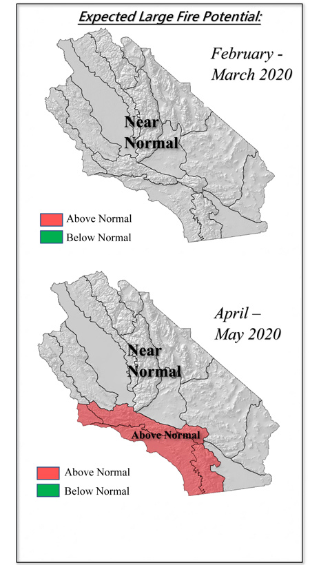 production of precipitation this past January. The ridge which was located over the Central Pacific late last year shifted eastward which prevented most storms from reaching the state. The systems which did manage to reach the Geographic Area in January were forced to take a circuitous, overland path which deprived them of moisture. There were a few light precipitation events over Central CA, but the vast majority of the state experienced far below normal precipitation during the past 30 days (Image 1, below).
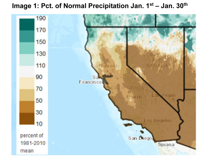
The subtle shift of the ridge that had dramatic implications regarding precipitation across the area will likely maintain itself through the rest of the winter. Sea surface temperatures (Image 2, below) continue to trend below normal over a wide area off the coast, but warmer than average conditions are still to be found in the Gulf of Alaska.
The ENSO index has not changed much from last month’s outlook . Warmer than normal conditions remain along the equator in the Nino 3.4 region, but temps are seemingly not warm enough to trigger much of a response in tropical moisture availability. Subtropical moisture, when it has arrived this winter, has arrived via an atmospheric river much further west across the Pacific as opposed to subtropical regions closer to California. The storms that do arrive the rest of the winter likely will have to rely on other areas of deeper moisture than nearby Nino regions.
As long as the ridge of high pressure holds sway in determining long wave patterns, it is apparent that there will be short periods of wetter weather followed by longer periods of drier than normal conditions. Some long range assessments were painting a bleak overall picture of winter weather this year last fall, based on strong ridging over the Pacific. These assessments were not entirely wrong; it was merely a shift westward of the ridge that allowed above normal rainfall to occur in late November into December. A few more shifts westward are possible over the next few weeks, but more often than not, this ridge will have a stifling effect on precipitation the rest of the winter.
Therefore, we are expecting precipitation to continue be below normal as a seasonal average this winter. The greatest precipitation deficits are expected to be over Southern CA due to the low likelihood of a subtropical moisture connection. The “winter rainy season” will likely end a few weeks earlier than normal with most areas seeing seasonal rainfall wrap up in mid or late March. Temperatures should remain a few degrees above normal this winter.
Offshore wind events are expected to continue at a near normal rate during the next 30 days. However, if the longwave pattern continues to be supportive of cold air advection across the Great Basin and central Rockies, offshore wind events may be stronger and more frequent than usual during the late winter into early spring months.
FUELS AND DROUGHT OUTLOOK
A cool, wet start to the beginning of winter continues to have lasting effects across the district. Higher elevations do have substantial snowpack, but official readings at the beginning of February will undoubtedly be quite a bit below normal. If the dry, warm pattern continues as expected, snowpack number will continue to lose ground vs normal values. It is possible if current trends continue, this winter’s maximum snow water content date be well before the normal maximums seen in late winter or early spring. As a result of this, meltout may be several weeks early this year.
At lower elevations, moisture in the upper layers of topsoil should continue to allow for seasonal grass growth for a few more weeks. But as this moisture becomes exhausted, grasses will begin to cure. It is likely that the seasonal curing of native grasses will be earlier than normal, and as a consequence, the onset “spring grassfire season” may occur by April 1st. There may be a spike in IA and resource demand associated with the curing of this year’s grass crop and large fire potential may climb to above normal levels in April and May. This may be compounded by a higher than normal number of offshore wind events during this time.
It is too early to pin a forecast on the upcoming summer’s monsoon season. But most factors, including SST’s support a near normal amount of summertime thunderstorms. This stands in contrast with very small number of thunderstorms seen during the past two summers. An increase in thunderstorms – which are an important ignition source in Central CA – may lead to the expansion of above normal large fire potential into the Sierras. The Sierra Foothills may again see the greatest likelihood of large fires this year due to a high amount of dead fuel loading and the possibility of more thunderstorms this summer. Overhead and resource demand may increase much more rapidly this spring and summer compared to the past two years. Out of region demand may also be higher than normal this spring as the Southwest and west slope of the Rockies are similarly dry (Image 5, below).
Source: Predictive Services

